File:Chile location map.svg
קפיצה לניווט
קפיצה לחיפוש

גודל התצוגה המקדימה הזאת מסוג PNG של קובץ ה־SVG הזה: 267 × 600 פיקסלים. רזולוציות אחרות: 107 × 240 פיקסלים | 213 × 480 פיקסלים | 342 × 768 פיקסלים | 455 × 1,024 פיקסלים | 911 × 2,048 פיקסלים | 1,183 × 2,658 פיקסלים.
לקובץ המקורי (קובץ SVG, הגודל המקורי: 1,183 × 2,658 פיקסלים, גודל הקובץ: 925 ק"ב)
כיתובים
כיתובים
נא להוסיף משפט שמסביר מה הקובץ מייצג
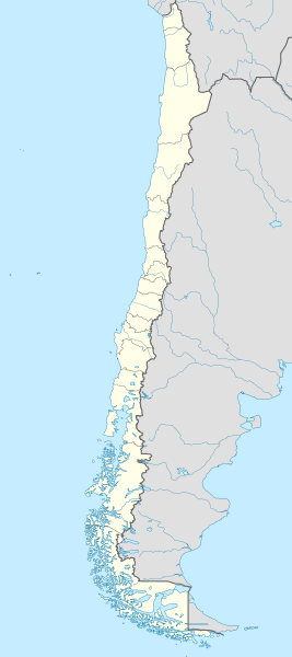
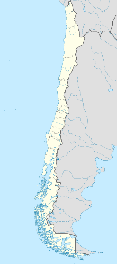
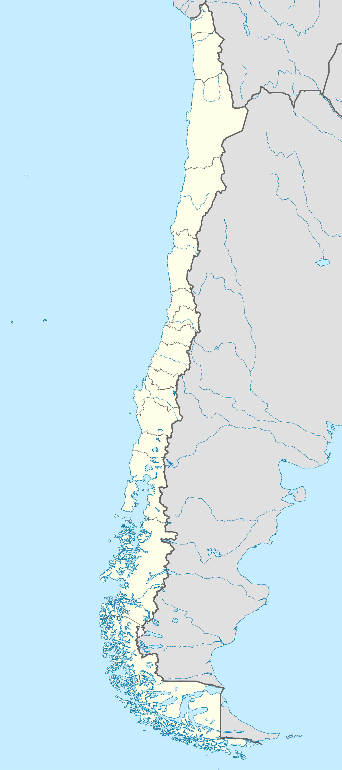
Map of Chile
תקציר[עריכה]
| תיאור |
Deutsch: Positionskarte von Chile
Quadratische Plattkarte, N-S-Streckung 115 %. Geographische Begrenzung der Karte:
English: Location map of Chile
Equirectangular projection, N/S stretching 115 %. Geographic limits of the map:
Español: Mapa de localización de Chile
Proyección Equirectangular, N/S con una extensión de 115 %. Límites geográficos del mapa:
|
| תאריך יצירה | |
| מקור |
own work, using
|
| יוצר | NordNordWest |
| גרסאות אחרות |
Derivative works of this file:
|
.svg)
.svg)
.svg)
.svg)

|
This map has been made or improved in the German Kartenwerkstatt (Map Lab). You can propose maps to improve as well.
|
רישיון[עריכה]
אני, בעל זכויות היוצרים על היצירה הזאת, מפרסם אותה בזאת תחת הרישיונות הבאים:

|
מוענקת בכך הרשות להעתיק, להפיץ או לשנות את המסמך הזה, לפי תנאי הרישיון לשימוש חופשי במסמכים של גנו, גרסה 1.2 או כל גרסה מאוחרת יותר שתפורסם על־ידי המוסד לתוכנה חופשית; ללא פרקים קבועים, ללא טקסט עטיפה קדמית וללא טקסט עטיפה אחורית. עותק של הרישיון כלול בפרק שכותרתו הרישיון לשימוש חופשי במסמכים של גנו. |
הקובץ הזה מתפרסם לפי תנאי רישיון קריאייטיב קומונז ייחוס-שיתוף זהה 3.0 לא מותאם.
- הנכם רשאים:
- לשתף – להעתיק, להפיץ ולהעביר את העבודה
- לערבב בין עבודות – להתאים את העבודה
- תחת התנאים הבאים:
- ייחוס – יש לתת ייחוס הולם, לתת קישור לרישיון, ולציין אם נעשו שינויים. אפשר לעשות את זה בכל צורה סבירה, אבל לא בשום צורה שמשתמע ממנה שמעניק הרישיון תומך בך או בשימוש שלך.
- שיתוף זהה – אם תיצרו רמיקס, תשנו, או תבנו על החומר, חובה עליכם להפיץ את התרומות שלך לפי תנאי רישיון זהה או תואם למקור.
הנכם מוזמנים לבחור את הרישיון הרצוי בעיניכם.
היסטוריית הקובץ
ניתן ללחוץ על תאריך/שעה כדי לראות את הקובץ כפי שנראה באותו זמן.
| תאריך/שעה | תמונה ממוזערת | ממדים | משתמש | הערה | |
|---|---|---|---|---|---|
| נוכחית | 22:46, 15 באוגוסט 2023 | | 2,658 × 1,183 (925 ק"ב) | Janitoalevic (שיחה | תרומות) | Fixed Aysén & Magallanes and Chilean Antarctica Regions border. |
| 22:54, 5 בספטמבר 2018 |  | 2,658 × 1,183 (925 ק"ב) | Janitoalevic (שיחה | תרומות) | Ñuble Region | |
| 20:30, 3 בדצמבר 2017 |  | 2,658 × 1,183 (921 ק"ב) | Janitoalevic (שיחה | תרומות) | color error. | |
| 20:28, 3 בדצמבר 2017 |  | 2,658 × 1,183 (921 ק"ב) | Janitoalevic (שיחה | תרומות) | Fixed Argentina's Lake Nahuel Huapi | |
| 20:25, 3 בדצמבר 2017 |  | 2,658 × 1,183 (920 ק"ב) | Janitoalevic (שיחה | תרומות) | . | |
| 21:50, 2 בדצמבר 2017 |  | 2,658 × 1,183 (920 ק"ב) | Janitoalevic (שיחה | תרומות) | Fixed Argentina-Bolivia border | |
| 21:46, 2 בדצמבר 2017 |  | 2,658 × 1,183 (920 ק"ב) | Janitoalevic (שיחה | תרומות) | . | |
| 00:42, 30 באוגוסט 2017 |  | 2,658 × 1,183 (919 ק"ב) | Janitoalevic (שיחה | תרומות) | Fixed size | |
| 23:30, 20 באוגוסט 2017 |  | 2,835 × 1,262 (910 ק"ב) | Janitoalevic (שיחה | תרומות) | Removed Ñuble Region (Will be fully implemented in 2018) | |
| 01:00, 20 באוגוסט 2017 |  | 2,835 × 1,262 (914 ק"ב) | Janitoalevic (שיחה | תרומות) | Added Ñuble Region & more precise borders |
אין באפשרותך לדרוס את הקובץ הזה.
שימוש בקובץ
הדפים הבאים משתמשים בקובץ הזה:
- Atlas of Chile
- Chile
- User:Janitoalevic/Gallery/Maps
- User:NordNordWest/Gallery/Location maps
- File:Aisen in Chile.svg
- File:Aisen in Chile (equirectangular projection).svg
- File:Aisen in Chile (equirectangular projection) (zoom).svg
- File:Aisen in Chile (square format).svg
- File:Antofagasta in Chile.svg
- File:Antofagasta in Chile (equirectangular projection).svg
- File:Antofagasta in Chile (equirectangular projection) (zoom).svg
- File:Antofagasta in Chile (square format).svg
- File:Araucania in Chile.svg
- File:Araucania in Chile (equirectangular projection).svg
- File:Araucania in Chile (equirectangular projection) (zoom).svg
- File:Araucania in Chile (square format).svg
- File:Arica and Parinacota in Chile.svg
- File:Arica and Parinacota in Chile (equirectangular projection).svg
- File:Arica and Parinacota in Chile (equirectangular projection) (zoom).svg
- File:Arica and Parinacota in Chile (special marker) (equirectangular projection).svg
- File:Arica and Parinacota in Chile (special marker) (square format).svg
- File:Arica and Parinacota in Chile (square format).svg
- File:Atacama in Chile.svg
- File:Atacama in Chile (equirectangular projection).svg
- File:Atacama in Chile (equirectangular projection) (zoom).svg
- File:Atacama in Chile (square format).svg
- File:BLANK in Chile.svg
- File:Biobio in Chile.svg
- File:Biobio in Chile (equirectangular projection).svg
- File:Biobio in Chile (equirectangular projection) (zoom).svg
- File:Biobio in Chile (square format).svg
- File:Central Chile location map.png
- File:Chile en Wikiviajes.svg
- File:Coquimbo in Chile.svg
- File:Coquimbo in Chile (equirectangular projection).svg
- File:Coquimbo in Chile (equirectangular projection) (zoom).svg
- File:Coquimbo in Chile (square format).svg
- File:Hippocamelus bisulcus.svg
- File:Los Lagos in Chile.svg
- File:Los Lagos in Chile (equirectangular projection).svg
- File:Los Lagos in Chile (equirectangular projection) (zoom).svg
- File:Los Lagos in Chile (square format).svg
- File:Los Rios in Chile.svg
- File:Los Rios in Chile (equirectangular projection).svg
- File:Los Rios in Chile (equirectangular projection) (zoom).svg
- File:Los Rios in Chile (special marker) (equirectangular projection).svg
- File:Los Rios in Chile (special marker) (square format).svg
- File:Los Rios in Chile (square format).svg
- File:Magallanes and Antartica Chilena in Chile.svg
- File:Magallanes and Antartica Chilena in Chile (+Antarctica claims).svg
- File:Magallanes and Antartica Chilena in Chile (+Antarctica claims) (+grid).svg
- File:Magallanes and Antartica Chilena in Chile (+Antarctica claims) (broad).svg
- File:Magallanes and Antartica Chilena in Chile (+Antarctica claims solid).svg
- File:Magallanes and Antartica Chilena in Chile (+Antarctica claims solid) (+grid).svg
- File:Magallanes and Antartica Chilena in Chile (+Antarctica claims solid) (broad).svg
- File:Magallanes and Antartica Chilena in Chile (equirectangular projection).svg
- File:Magallanes and Antartica Chilena in Chile (square format).svg
- File:Maule in Chile.svg
- File:Maule in Chile (equirectangular projection).svg
- File:Maule in Chile (equirectangular projection) (zoom).svg
- File:Maule in Chile (special marker) (square format).svg
- File:Maule in Chile (square format).svg
- File:Northern Chile location map.png
- File:OHiggins in Chile (equirectangular projection).svg
- File:OHiggins in Chile (equirectangular projection) (zoom).svg
- File:OHiggins in Chile (special marker) (equirectangular projection).svg
- File:O Higgins in Chile.svg
- File:O Higgins in Chile (special marker) (square format).svg
- File:O Higgins in Chile (square format).svg
- File:Patagonia location map.png
- File:Relief Map of Chile.jpg
- File:Santiago Metropolitan in Chile.svg
- File:Santiago Metropolitan in Chile (equirectangular projection).svg
- File:Santiago Metropolitan in Chile (equirectangular projection) (zoom).svg
- File:Santiago Metropolitan in Chile (special marker) (equirectangular projection).svg
- File:Santiago Metropolitan in Chile (special marker) (square format).svg
- File:Santiago Metropolitan in Chile (square format).svg
- File:Southern Chile location map.png
- File:Tarapaca in Chile.svg
- File:Tarapaca in Chile (equirectangular projection).svg
- File:Tarapaca in Chile (equirectangular projection) (zoom).svg
- File:Tarapaca in Chile (square format).svg
- File:Telmatobufo australis.svg
- File:Telmatobufo bullocki.svg
- File:Telmatobufo venustus.svg
- File:Valparaiso in Chile.svg
- File:Valparaiso in Chile (+near islands) (double special marker) (square format).svg
- File:Valparaiso in Chile (+near islands) (special marker) (square format).svg
- File:Valparaiso in Chile (+near islands) (square format).svg
- File:Valparaiso in Chile (+outer islands).svg
- File:Valparaiso in Chile (+outer islands) (special marker).svg
- File:Valparaiso in Chile (equirectangular projection).svg
- File:Valparaiso in Chile (equirectangular projection) (zoom).svg
- File:Valparaiso in Chile (special marker) (equirectangular projection).svg
- File:Valparaiso in Chile (square format).svg
- File:चिली का मानचित्र कॉन्सेप्सिओन.png
.svg)
_(zoom).svg)
.svg)
.svg)
_(zoom).svg)
.svg)
.svg)
_(zoom).svg)
.svg)
.svg)
_(zoom).svg)
_(equirectangular_projection).svg)
_(square_format).svg)
.svg)
.svg)
_(zoom).svg)
.svg)
.svg)
_(zoom).svg)
.svg)
.svg)
_(zoom).svg)
.svg)
.svg)
_(zoom).svg)
.svg)
.svg)
_(zoom).svg)
_(equirectangular_projection).svg)
_(square_format).svg)
.svg)
.svg)
_(%2Bgrid).svg)
_(broad).svg)
.svg)
_(%2Bgrid).svg)
_(broad).svg)
.svg)
.svg)
.svg)
_(zoom).svg)
_(square_format).svg)
.svg)
.svg)
_(zoom).svg)
_(equirectangular_projection).svg)
_(square_format).svg)
.svg)
.svg)
_(zoom).svg)
_(equirectangular_projection).svg)
_(square_format).svg)
.svg)
.svg)
_(zoom).svg)
.svg)
_(double_special_marker)_(square_format).svg)
_(special_marker)_(square_format).svg)
_(square_format).svg)
.svg)
_(special_marker).svg)
.svg)
_(zoom).svg)
_(equirectangular_projection).svg)
.svg)
שימוש גלובלי בקובץ
אתרי הוויקי השונים הבאים משתמשים בקובץ זה:
- שימוש באתר af.wikipedia.org
- Antofagasta
- Pichilemu
- FIFA Sokker-Wêreldbekertoernooi in 1962
- Chillán
- Los Ángeles (Chili)
- Talcahuano
- Quinta Normal
- Temuco
- Puerto Montt
- Punta Arenas
- Coyhaique
- Valdivia
- Castro (Chili)
- San Pedro de la Paz
- Villa Alemana
- Sjabloon:Liggingkaart Chili
- Penco
- Hualpén
- Chiguayante
- Hualqui
- Coronel (Chili)
- Lota
- Tomé
- La Serena
- Arica
- Monte Águila (Chili)
- Arturo Merino Benítez Internasionale Lughawe
- שימוש באתר als.wikipedia.org
- שימוש באתר an.wikipedia.org
צפייה בשימושים גלובליים נוספים של קובץ זה.