File:Chile location map.svg
둘러보기로 이동
검색으로 이동

SVG 파일의 PNG 형식의 미리보기 크기: 267 × 600 픽셀. 다른 해상도: 107 × 240 픽셀 | 213 × 480 픽셀 | 342 × 768 픽셀 | 455 × 1,024 픽셀 | 911 × 2,048 픽셀 | 1,183 × 2,658 픽셀
원본 파일 (SVG 파일, 실제 크기 1,183 × 2,658 픽셀, 파일 크기: 925 KB)
캡션
설명
이 파일이 나타내는 바에 대한 한 줄 설명을 추가합니다
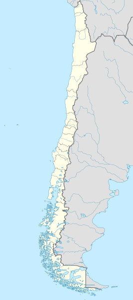
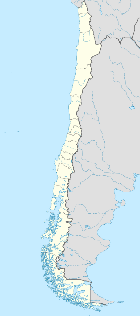
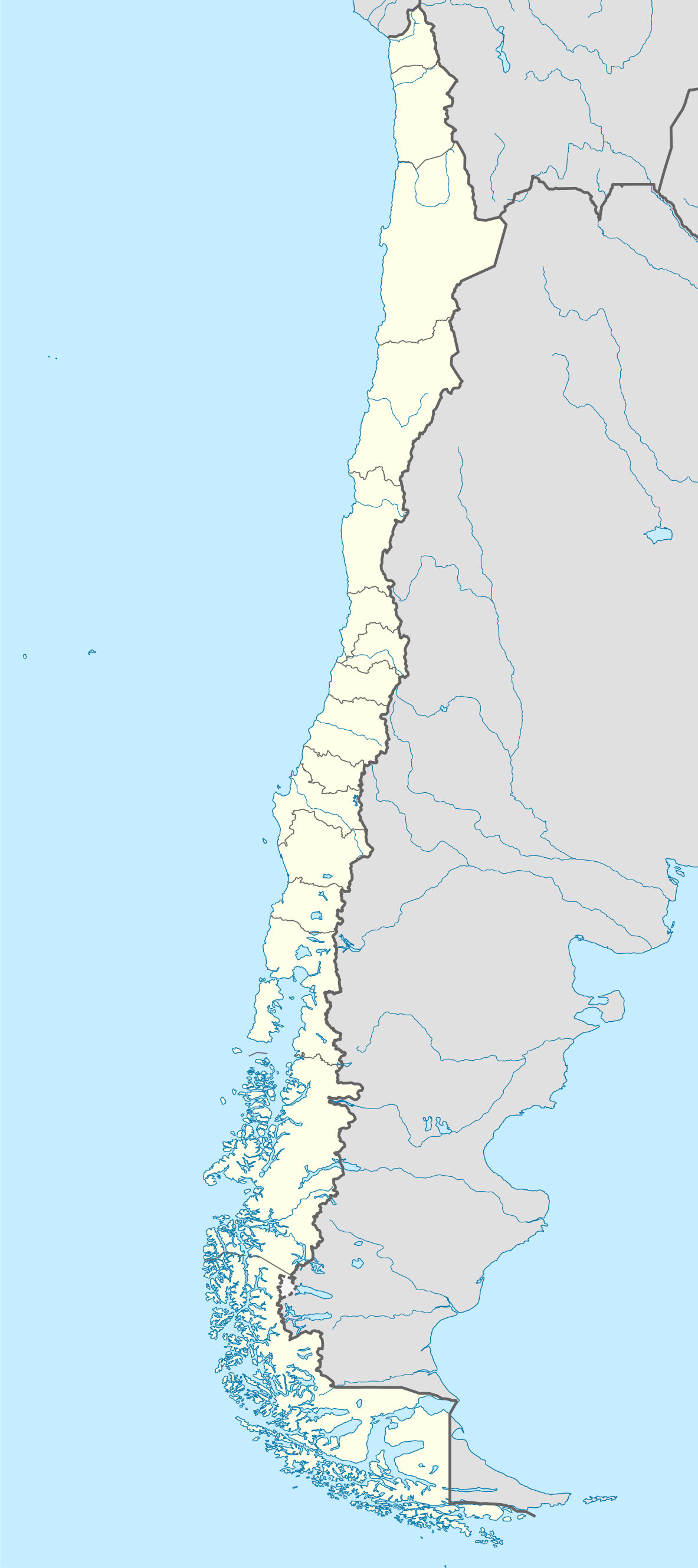
Map of Chile
파일 설명
[편집]
| 설명 |
Deutsch: Positionskarte von Chile
Quadratische Plattkarte, N-S-Streckung 115 %. Geographische Begrenzung der Karte:
English: Location map of Chile
Equirectangular projection, N/S stretching 115 %. Geographic limits of the map:
Español: Mapa de localización de Chile
Proyección Equirectangular, N/S con una extensión de 115 %. Límites geográficos del mapa:
|
| 날짜 | |
| 출처 |
own work, using
|
| 저자 | NordNordWest |
| 다른 버전 |
이 파일은 다음으로 파생됨:
|
.svg)
.svg)
.svg)
.svg)

|
This map has been made or improved in the German Kartenwerkstatt (Map Lab). You can propose maps to improve as well.
|
라이선스
[편집]
나는 아래 작품의 저작권자로서, 이 저작물을 다음과 같은 라이선스로 배포합니다:

|
GNU 자유 문서 사용 허가서 1.2판 또는 자유 소프트웨어 재단에서 발행한 이후 판의 규정에 따라 본 문서를 복제하거나 개작 및 배포할 수 있습니다. 본 문서에는 변경 불가 부분이 없으며, 앞 표지 구절과 뒷 표지 구절도 없습니다. 본 사용 허가서의 전체 내용은 GNU 자유 문서 사용 허가서 부분에 포함되어 있습니다. |
이 파일은 크리에이티브 커먼즈 저작자표시-동일조건변경허락 3.0 Unported 라이선스로 배포됩니다.
- 이용자는 다음의 권리를 갖습니다:
- 공유 및 이용 – 저작물의 복제, 배포, 전시, 공연 및 공중송신
- 재창작 – 저작물의 개작, 수정, 2차적저작물 창작
- 다음과 같은 조건을 따라야 합니다:
- 저작자표시 – 적절한 저작자 표시를 제공하고, 라이센스에 대한 링크를 제공하고, 변경사항이 있는지를 표시해야 합니다. 당신은 합리적인 방식으로 표시할 수 있지만, 어떤 방식으로든 사용권 허가자가 당신 또는 당신의 사용을 지지하는 방식으로 표시할 수 없습니다.
- 동일조건변경허락 – 만약 당신이 이 저작물을 리믹스 또는 변형하거나 이 저작물을 기반으로 제작하는 경우, 당신은 당신의 기여물을 원저작물과 동일하거나 호환 가능한 라이선스에 따라 배포하여야 합니다.
이 라이선스 중에서 목적에 맞는 것을 선택하여 사용할 수 있습니다.
파일 역사
날짜/시간 링크를 클릭하면 해당 시간의 파일을 볼 수 있습니다.
| 날짜/시간 | 섬네일 | 크기 | 사용자 | 설명 | |
|---|---|---|---|---|---|
| 현재 | 2023년 8월 15일 (화) 22:46 | | 1,183 × 2,658 (925 KB) | Janitoalevic (토론 | 기여) | Fixed Aysén & Magallanes and Chilean Antarctica Regions border. |
| 2018년 9월 5일 (수) 22:54 |  | 1,183 × 2,658 (925 KB) | Janitoalevic (토론 | 기여) | Ñuble Region | |
| 2017년 12월 3일 (일) 20:30 |  | 1,183 × 2,658 (921 KB) | Janitoalevic (토론 | 기여) | color error. | |
| 2017년 12월 3일 (일) 20:28 |  | 1,183 × 2,658 (921 KB) | Janitoalevic (토론 | 기여) | Fixed Argentina's Lake Nahuel Huapi | |
| 2017년 12월 3일 (일) 20:25 |  | 1,183 × 2,658 (920 KB) | Janitoalevic (토론 | 기여) | . | |
| 2017년 12월 2일 (토) 21:50 |  | 1,183 × 2,658 (920 KB) | Janitoalevic (토론 | 기여) | Fixed Argentina-Bolivia border | |
| 2017년 12월 2일 (토) 21:46 |  | 1,183 × 2,658 (920 KB) | Janitoalevic (토론 | 기여) | . | |
| 2017년 8월 30일 (수) 00:42 |  | 1,183 × 2,658 (919 KB) | Janitoalevic (토론 | 기여) | Fixed size | |
| 2017년 8월 20일 (일) 23:30 |  | 1,262 × 2,835 (910 KB) | Janitoalevic (토론 | 기여) | Removed Ñuble Region (Will be fully implemented in 2018) | |
| 2017년 8월 20일 (일) 01:00 |  | 1,262 × 2,835 (914 KB) | Janitoalevic (토론 | 기여) | Added Ñuble Region & more precise borders |
이 파일을 덮어쓸 수 없습니다.
이 파일을 사용하는 문서
다음 문서 96개가 이 파일을 사용하고 있습니다:
- Atlas of Chile
- Chile
- User:Janitoalevic/Gallery/Maps
- User:NordNordWest/Gallery/Location maps
- File:Aisen in Chile.svg
- File:Aisen in Chile (equirectangular projection).svg
- File:Aisen in Chile (equirectangular projection) (zoom).svg
- File:Aisen in Chile (square format).svg
- File:Antofagasta in Chile.svg
- File:Antofagasta in Chile (equirectangular projection).svg
- File:Antofagasta in Chile (equirectangular projection) (zoom).svg
- File:Antofagasta in Chile (square format).svg
- File:Araucania in Chile.svg
- File:Araucania in Chile (equirectangular projection).svg
- File:Araucania in Chile (equirectangular projection) (zoom).svg
- File:Araucania in Chile (square format).svg
- File:Arica and Parinacota in Chile.svg
- File:Arica and Parinacota in Chile (equirectangular projection).svg
- File:Arica and Parinacota in Chile (equirectangular projection) (zoom).svg
- File:Arica and Parinacota in Chile (special marker) (equirectangular projection).svg
- File:Arica and Parinacota in Chile (special marker) (square format).svg
- File:Arica and Parinacota in Chile (square format).svg
- File:Atacama in Chile.svg
- File:Atacama in Chile (equirectangular projection).svg
- File:Atacama in Chile (equirectangular projection) (zoom).svg
- File:Atacama in Chile (square format).svg
- File:BLANK in Chile.svg
- File:Biobio in Chile.svg
- File:Biobio in Chile (equirectangular projection).svg
- File:Biobio in Chile (equirectangular projection) (zoom).svg
- File:Biobio in Chile (square format).svg
- File:Central Chile location map.png
- File:Chile en Wikiviajes.svg
- File:Coquimbo in Chile.svg
- File:Coquimbo in Chile (equirectangular projection).svg
- File:Coquimbo in Chile (equirectangular projection) (zoom).svg
- File:Coquimbo in Chile (square format).svg
- File:Hippocamelus bisulcus.svg
- File:Los Lagos in Chile.svg
- File:Los Lagos in Chile (equirectangular projection).svg
- File:Los Lagos in Chile (equirectangular projection) (zoom).svg
- File:Los Lagos in Chile (square format).svg
- File:Los Rios in Chile.svg
- File:Los Rios in Chile (equirectangular projection).svg
- File:Los Rios in Chile (equirectangular projection) (zoom).svg
- File:Los Rios in Chile (special marker) (equirectangular projection).svg
- File:Los Rios in Chile (special marker) (square format).svg
- File:Los Rios in Chile (square format).svg
- File:Magallanes and Antartica Chilena in Chile.svg
- File:Magallanes and Antartica Chilena in Chile (+Antarctica claims).svg
- File:Magallanes and Antartica Chilena in Chile (+Antarctica claims) (+grid).svg
- File:Magallanes and Antartica Chilena in Chile (+Antarctica claims) (broad).svg
- File:Magallanes and Antartica Chilena in Chile (+Antarctica claims solid).svg
- File:Magallanes and Antartica Chilena in Chile (+Antarctica claims solid) (+grid).svg
- File:Magallanes and Antartica Chilena in Chile (+Antarctica claims solid) (broad).svg
- File:Magallanes and Antartica Chilena in Chile (equirectangular projection).svg
- File:Magallanes and Antartica Chilena in Chile (square format).svg
- File:Maule in Chile.svg
- File:Maule in Chile (equirectangular projection).svg
- File:Maule in Chile (equirectangular projection) (zoom).svg
- File:Maule in Chile (special marker) (square format).svg
- File:Maule in Chile (square format).svg
- File:Northern Chile location map.png
- File:OHiggins in Chile (equirectangular projection).svg
- File:OHiggins in Chile (equirectangular projection) (zoom).svg
- File:OHiggins in Chile (special marker) (equirectangular projection).svg
- File:O Higgins in Chile.svg
- File:O Higgins in Chile (special marker) (square format).svg
- File:O Higgins in Chile (square format).svg
- File:Patagonia location map.png
- File:Relief Map of Chile.jpg
- File:Santiago Metropolitan in Chile.svg
- File:Santiago Metropolitan in Chile (equirectangular projection).svg
- File:Santiago Metropolitan in Chile (equirectangular projection) (zoom).svg
- File:Santiago Metropolitan in Chile (special marker) (equirectangular projection).svg
- File:Santiago Metropolitan in Chile (special marker) (square format).svg
- File:Santiago Metropolitan in Chile (square format).svg
- File:Southern Chile location map.png
- File:Tarapaca in Chile.svg
- File:Tarapaca in Chile (equirectangular projection).svg
- File:Tarapaca in Chile (equirectangular projection) (zoom).svg
- File:Tarapaca in Chile (square format).svg
- File:Telmatobufo australis.svg
- File:Telmatobufo bullocki.svg
- File:Telmatobufo venustus.svg
- File:Valparaiso in Chile.svg
- File:Valparaiso in Chile (+near islands) (double special marker) (square format).svg
- File:Valparaiso in Chile (+near islands) (special marker) (square format).svg
- File:Valparaiso in Chile (+near islands) (square format).svg
- File:Valparaiso in Chile (+outer islands).svg
- File:Valparaiso in Chile (+outer islands) (special marker).svg
- File:Valparaiso in Chile (equirectangular projection).svg
- File:Valparaiso in Chile (equirectangular projection) (zoom).svg
- File:Valparaiso in Chile (special marker) (equirectangular projection).svg
- File:Valparaiso in Chile (square format).svg
- File:चिली का मानचित्र कॉन्सेप्सिओन.png
.svg)
_(zoom).svg)
.svg)
.svg)
_(zoom).svg)
.svg)
.svg)
_(zoom).svg)
.svg)
.svg)
_(zoom).svg)
_(equirectangular_projection).svg)
_(square_format).svg)
.svg)
.svg)
_(zoom).svg)
.svg)
.svg)
_(zoom).svg)
.svg)
.svg)
_(zoom).svg)
.svg)
.svg)
_(zoom).svg)
.svg)
.svg)
_(zoom).svg)
_(equirectangular_projection).svg)
_(square_format).svg)
.svg)
.svg)
_(%2Bgrid).svg)
_(broad).svg)
.svg)
_(%2Bgrid).svg)
_(broad).svg)
.svg)
.svg)
.svg)
_(zoom).svg)
_(square_format).svg)
.svg)
.svg)
_(zoom).svg)
_(equirectangular_projection).svg)
_(square_format).svg)
.svg)
.svg)
_(zoom).svg)
_(equirectangular_projection).svg)
_(square_format).svg)
.svg)
.svg)
_(zoom).svg)
.svg)
_(double_special_marker)_(square_format).svg)
_(special_marker)_(square_format).svg)
_(square_format).svg)
.svg)
_(special_marker).svg)
.svg)
_(zoom).svg)
_(equirectangular_projection).svg)
.svg)
이 파일을 사용하고 있는 모든 위키의 문서 목록
다음 위키에서 이 파일을 사용하고 있습니다:
- af.wikipedia.org에서 이 파일을 사용하고 있는 문서 목록
- Antofagasta
- Pichilemu
- FIFA Sokker-Wêreldbekertoernooi in 1962
- Chillán
- Los Ángeles (Chili)
- Talcahuano
- Quinta Normal
- Temuco
- Puerto Montt
- Punta Arenas
- Coyhaique
- Valdivia
- Castro (Chili)
- San Pedro de la Paz
- Villa Alemana
- Sjabloon:Liggingkaart Chili
- Penco
- Hualpén
- Chiguayante
- Hualqui
- Coronel (Chili)
- Lota
- Tomé
- La Serena
- Arica
- Monte Águila (Chili)
- Arturo Merino Benítez Internasionale Lughawe
- als.wikipedia.org에서 이 파일을 사용하고 있는 문서 목록
- an.wikipedia.org에서 이 파일을 사용하고 있는 문서 목록
이 파일의 더 많은 사용 내역을 봅니다.