File:Cohasset.jpg

File originale (4 627 × 3 142 pixel, dimensione del file: 2,95 MB, tipo MIME: image/jpeg)
Didascalie
Didascalie
Dettagli[modifica]
|
Questa è un'immagine di un luogo o edificio che è elencato nel National Register of Historic Places negli Stati Uniti. Il suo numero di riferimento è [https://npgallery.nps.gov/AssetDetail/NRIS/86001935
. 86001935
.]. |
| Descrizione |
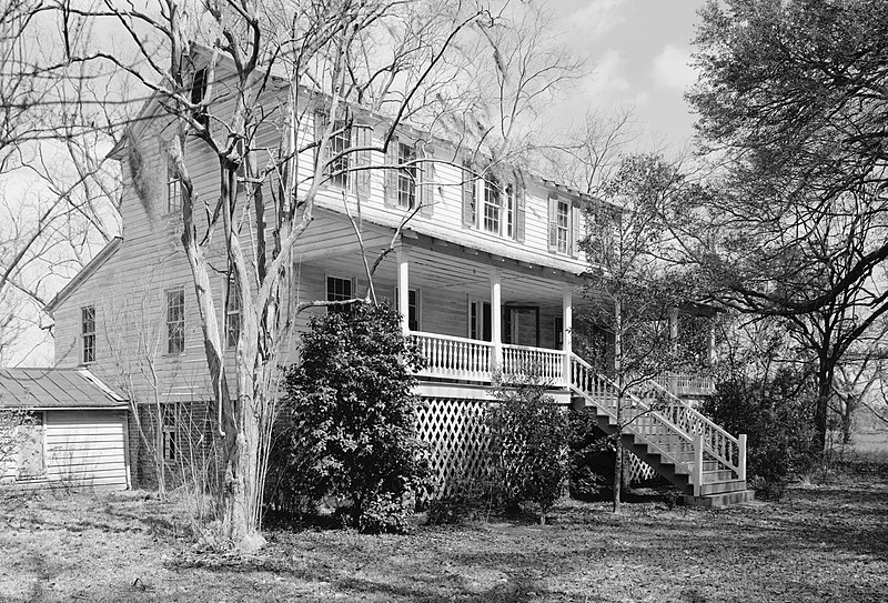
English: Cohasset, US 601, 1 mile North of Crocketville, Crocketville vicinity, Hampton County, SC. SOUTHEAST (FRONT) AND SOUTHWEST SIDE ELEVATIONS, LOOKING EAST. (From HABS: Built in 1873. Significance: Excellent example of Carolina I house, a vernacular house type popular from the late 18th through the early 20th century. Associated with William James Gooding, a cotton farmer who played a locally important role in politics and government. In addition, the property, which includes several late 19th century outbuildings and a late 19th century tenant house, is significant for information it reveals about post-Civil War agricultural practices.) |
|||||||||||||||||||||||||
| Data | ||||||||||||||||||||||||||
| Fonte |
Historic American Buildings Survey,Library of Congress, Prints & Photographs Division, HABS [or HAER or HALS], Reproduction number "HABS SC,25-CROV.V,1-4"
|
|||||||||||||||||||||||||
| Autore |
|
|||||||||||||||||||||||||
| Licenza (Riusare questo file) |
|
|||||||||||||||||||||||||


| Posizione del soggetto | | Posizione di questa e altre immagini su: OpenStreetMap |
|---|
Cronologia del file
Fare clic su un gruppo data/ora per vedere il file come si presentava nel momento indicato.
| Data/Ora | Miniatura | Dimensioni | Utente | Commento | |
|---|---|---|---|---|---|
| attuale | 17:24, 26 mar 2009 | | 4 627 × 3 142 (2,95 MB) | Martin H. (discussione | contributi) | High res; cropped |
| 20:48, 10 ott 2008 |  | 935 × 648 (580 KB) | Altairisfar (discussione | contributi) | == Summary == {{Information |Description={{en|Cohasset, US 601, 1 mile North of Crocketville, Crocketville vicinity, Hampton County, SC. SOUTHEAST (FRONT) AND SOUTHWEST SIDE ELEVATIONS, LOOKING EAST. (From HABS: Built in 1873. Significance: Excellent ex |
Impossibile sovrascrivere questo file.
Utilizzo del file
La seguente pagina usa questo file:
Utilizzo globale del file
Anche i seguenti wiki usano questo file:
- Usato nelle seguenti pagine di en.wikipedia.org:
- Usato nelle seguenti pagine di es.wikipedia.org:
- Usato nelle seguenti pagine di fa.wikipedia.org:
- Usato nelle seguenti pagine di it.wikipedia.org:
- Usato nelle seguenti pagine di www.wikidata.org:
Metadati
- Plantation houses in South Carolina
- National Register of Historic Places in Hampton County, South Carolina
- I-houses
- Historic American Buildings Survey of South Carolina
- Black and white photographs of South Carolina
- Houses on the National Register of Historic Places in South Carolina
- Built in South Carolina in 1873