File:Continental Blockade (1812).svg
Vai alla navigazione
Vai alla ricerca

Dimensioni di questa anteprima PNG per questo file SVG: 450 × 456 pixel. Altre risoluzioni: 237 × 240 pixel | 474 × 480 pixel | 758 × 768 pixel | 1 011 × 1 024 pixel | 2 021 × 2 048 pixel.
File originale (file in formato SVG, dimensioni nominali 450 × 456 pixel, dimensione del file: 611 KB)
Didascalie
Didascalie
Aggiungi una brevissima spiegazione di ciò che questo file rappresenta
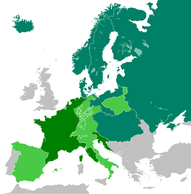
The French Empire in 1812
Dettagli
[modifica]| Descrizione |
English: The French Empire in 1812, including the Continental Blockade.
|
||
| Data | |||
| Fonte |
Opera propria Questa mappa include elementi che sono stati presi o adattati da questa: |
||
| Autore | TRAJAN 117 | ||
| Licenza (Riusare questo file) |
Io, detentore del copyright su quest'opera, dichiaro di pubblicarla con le seguenti licenze:
Questo file è disponibile in base alle licenze Creative Commons Attribuzione-Condividi allo stesso modo 3.0 Unported, 2.5 Generico, 2.0 Generico e 1.0 Generico
Puoi scegliere la licenza che preferisci. |
||
| SVG sviluppo | Il codice sorgente di questo file SVG non è valido a causa di 20 errori. Questa mappa in grafica vettoriale non valida secondo il W3C è stata creata con Inkscape. |

.svg&action=edit§ion=1)
Cronologia del file
Fare clic su un gruppo data/ora per vedere il file come si presentava nel momento indicato.
| Data/Ora | Miniatura | Dimensioni | Utente | Commento | |
|---|---|---|---|---|---|
| attuale | 13:09, 14 gen 2019 | | 450 × 456 (611 KB) | Lencer (discussione | contributi) | Iceland was part of Denmark |
| 15:01, 5 gen 2018 |  | 450 × 456 (611 KB) | TRAJAN 117 (discussione | contributi) | +++ | |
| 11:51, 27 dic 2017 |  | 450 × 456 (610 KB) | TRAJAN 117 (discussione | contributi) | +++ | |
| 01:12, 25 dic 2017 |  | 450 × 456 (610 KB) | TRAJAN 117 (discussione | contributi) | User created page with UploadWizard |
Impossibile sovrascrivere questo file.
Utilizzo del file
Le seguenti 3 pagine usano questo file:
Utilizzo globale del file
Anche i seguenti wiki usano questo file:
- Usato nelle seguenti pagine di ar.wikipedia.org:
- Usato nelle seguenti pagine di ast.wikipedia.org:
- Usato nelle seguenti pagine di be-tarask.wikipedia.org:
- Usato nelle seguenti pagine di ca.wikipedia.org:
- Usato nelle seguenti pagine di ckb.wikipedia.org:
- Usato nelle seguenti pagine di de.wikipedia.org:
- Usato nelle seguenti pagine di de.wikibooks.org:
- Usato nelle seguenti pagine di de.wikiversity.org:
- Usato nelle seguenti pagine di en.wikipedia.org:
- Usato nelle seguenti pagine di es.wikipedia.org:
- Usato nelle seguenti pagine di fr.wikipedia.org:
- Usato nelle seguenti pagine di he.wikipedia.org:
- Usato nelle seguenti pagine di hi.wikipedia.org:
- Usato nelle seguenti pagine di it.wikipedia.org:
- Usato nelle seguenti pagine di lv.wikipedia.org:
- Usato nelle seguenti pagine di no.wikipedia.org:
- Usato nelle seguenti pagine di pl.wikipedia.org:
- Usato nelle seguenti pagine di ru.wikipedia.org:
- Usato nelle seguenti pagine di sh.wikipedia.org:
- Usato nelle seguenti pagine di zh.wikipedia.org:
.svg&oldid=867846471)