File:DKR map.jpg
Jump to navigation
Jump to search
No higher resolution available.
DKR_map.jpg (291 × 242 pixels, file size: 16 KB, MIME type: image/jpeg)
Captions
Captions
Add a one-line explanation of what this file represents
Summary[edit]
| Description |
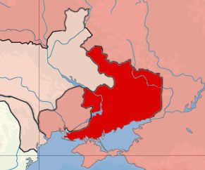
Русский: Карта расположения Донецко-Криворожской республики
Français : Carte de localisation de la République Donetsk-Krivoy Rog (1918–1919). |
| Date | |
| Source | Own work |
| Author | Николай Сидоров |
Licensing[edit]
| This work has been released into the public domain by its author, Nicolay Sidorov at Russian Wikipedia. This applies worldwide. In some countries this may not be legally possible; if so: Nicolay Sidorov grants anyone the right to use this work for any purpose, without any conditions, unless such conditions are required by law. |
Original upload log[edit]
The original description page was here. All following user names refer to ru.wikipedia.
- 2008-07-28 22:03 Nicolay Sidorov 291×242× (15917 bytes) {{Изображение | Описание = Карта расположения Донецко-Криворожской республики | Автор = Николай Сидоров | Время создания = 2008 | Источн�
File history
Click on a date/time to view the file as it appeared at that time.
| Date/Time | Thumbnail | Dimensions | User | Comment | |
|---|---|---|---|---|---|
| current | 10:33, 18 November 2010 | | 291 × 242 (16 KB) | Rubinbot (talk | contribs) | {{BotMoveToCommons|ru.wikipedia|year={{subst:CURRENTYEAR}}|month={{subst:CURRENTMONTHNAME}}|day={{subst:CURRENTDAY}}}} {{Information |Description={{ru|Карта расположения Донецко-Криворожской республики}} |So |
You cannot overwrite this file.
File usage on Commons
The following page uses this file:
File usage on other wikis
The following other wikis use this file:
- Usage on ast.wikipedia.org
- Usage on be.wikipedia.org
- Usage on ca.wikipedia.org
- Usage on cs.wikipedia.org
- Usage on de.wikipedia.org
- Usage on en.wikipedia.org
- Usage on fr.wikipedia.org
- Usage on gl.wikipedia.org
- Usage on id.wikipedia.org
- Usage on it.wikipedia.org
- Usage on ja.wikipedia.org
- Usage on ko.wikipedia.org
- Usage on nl.wikipedia.org
- Usage on pl.wikipedia.org
- Usage on pt.wikipedia.org
- Usage on ru.wikipedia.org
- Usage on ru.wikinews.org
- Usage on th.wikipedia.org
- Usage on uk.wikipedia.org
- Usage on www.wikidata.org
- Usage on zh.wikipedia.org