File:Dakar districts.svg
Jump to navigation
Jump to search

Size of this PNG preview of this SVG file: 260 × 260 pixels. Other resolutions: 240 × 240 pixels | 480 × 480 pixels | 768 × 768 pixels | 1,024 × 1,024 pixels | 2,048 × 2,048 pixels.
Original file (SVG file, nominally 260 × 260 pixels, file size: 100 KB)
Captions
Captions
Add a one-line explanation of what this file represents
Summary[edit]
| Description |
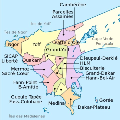
English: Dakar districts map |
| Date | |
| Source | Own work |
| Author | Mikima |
| Other versions |
|

| Camera location | | View this and other nearby images on: OpenStreetMap |
|---|
Licensing[edit]
I, the copyright holder of this work, hereby publish it under the following license:
This file is licensed under the Creative Commons Attribution-Share Alike 3.0 Unported license.
- You are free:
- to share – to copy, distribute and transmit the work
- to remix – to adapt the work
- Under the following conditions:
- attribution – You must give appropriate credit, provide a link to the license, and indicate if changes were made. You may do so in any reasonable manner, but not in any way that suggests the licensor endorses you or your use.
- share alike – If you remix, transform, or build upon the material, you must distribute your contributions under the same or compatible license as the original.
File history
Click on a date/time to view the file as it appeared at that time.
| Date/Time | Thumbnail | Dimensions | User | Comment | |
|---|---|---|---|---|---|
| current | 12:56, 25 October 2013 | | 260 × 260 (100 KB) | Mikima (talk | contribs) | Typos |
| 11:08, 25 October 2013 |  | 260 × 260 (100 KB) | Mikima (talk | contribs) | font update | |
| 10:53, 25 October 2013 |  | 260 × 260 (100 KB) | Mikima (talk | contribs) | Font properly setted | |
| 10:52, 25 October 2013 |  | 260 × 260 (100 KB) | Mikima (talk | contribs) | Reverted to version as of 10:28, 25 October 2013 - font not properly setted | |
| 10:39, 25 October 2013 |  | 260 × 260 (100 KB) | Mikima (talk | contribs) | Updated fonts according to https://meta.wikimedia.org/wiki/SVG_fonts, used DejaVu | |
| 10:28, 25 October 2013 |  | 260 × 260 (100 KB) | Mikima (talk | contribs) | Added a layer of color-coded regions, according to wikipedia main used colors. | |
| 02:33, 25 October 2013 |  | 260 × 260 (45 KB) | Mikima (talk | contribs) | Updated colors to match other maps style | |
| 02:25, 25 October 2013 |  | 260 × 260 (44 KB) | Mikima (talk | contribs) | Optimized for low resolution | |
| 01:59, 25 October 2013 |  | 2,000 × 2,000 (44 KB) | Mikima (talk | contribs) | User created page with UploadWizard |
You cannot overwrite this file.
File usage on Commons
The following page uses this file:
File usage on other wikis
The following other wikis use this file:
- Usage on af.wikipedia.org
- Usage on azb.wikipedia.org
- Usage on ceb.wikipedia.org
- Usage on de.wikipedia.org
- Dakar
- Ngor (Dakar)
- Yoff (Dakar)
- Ouakam
- Mermoz-Sacré Cœur
- Fann-Point E-Amitié
- Gueule Tapée-Fass-Colobane
- HLM (Dakar)
- Médina (Dakar)
- Grand Dakar
- Biscuiterie (Dakar)
- Dieuppeul-Derklé
- Sicap-Liberté
- Grand Yoff
- Arrondissement des Almadies
- Arrondissement de Grand Dakar
- Arrondissement de Dakar Plateau
- Arrondissement des Parcelles Assainies
- Patte d’Oie
- Parcelles Assainies
- Cambérène
- Hann-Bel Air
- Dakar Plateau
- Wikipedia:Kartenwerkstatt/Archiv/2019-08
- Usage on de.wikivoyage.org
- Usage on en.wikipedia.org
- Usage on eo.wikipedia.org
- Usage on fa.wikipedia.org
- Usage on fr.wikipedia.org
- Usage on id.wikipedia.org
- Usage on it.wikipedia.org
- Usage on it.wikivoyage.org
- Usage on ja.wikipedia.org
- Usage on la.wikipedia.org
- Usage on ms.wikipedia.org
- Usage on oc.wikipedia.org
- Usage on ps.wikipedia.org
- Usage on pt.wikipedia.org
- Usage on sat.wikipedia.org
- Usage on sco.wikipedia.org
- Usage on sd.wikipedia.org
- Usage on sh.wikipedia.org
- Usage on simple.wikipedia.org
- Usage on th.wikipedia.org
- Usage on vep.wikipedia.org
View more global usage of this file.