File:Deutschland Autobahnen.svg

원본 파일 (SVG 파일, 실제 크기 1,073 × 1,272 픽셀, 파일 크기: 467 KB)
캡션
설명
파일 설명
[편집]| 설명 |
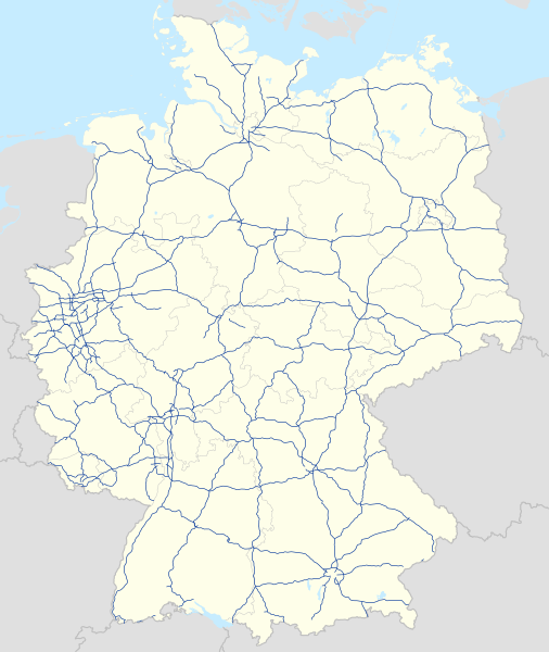
Deutsch: Karte der Autobahnen in Deutschland, Alternativkarte zu file:Germany location map.svg
|
||
| 날짜 | |||
| 출처 | 자작 | ||
| 저자 | NordNordWest | ||
| 저작권 (이 파일을 인용하기) |
이 파일은 크리에이티브 커먼즈 저작자표시-동일조건변경허락 3.0 독일 라이선스로 배포됩니다.
 이 파일은 크리에이티브 커먼즈 저작자표시-동일조건변경허락 3.0 Unported 라이선스로 배포됩니다.
|
||
| 다른 버전 |
Bundesrepublik Deutschland (vor 1990 nur West-Deutschland):
Deutsche Demokratische Republik (mit BRD im Ausschnitt):
Ostdeutschland (vor 1990 Deutsche Demokratische Republik):
Deutschland zwischen Mai 1945 und Oktober 1949:
Thematisch:
Deutsches Reich (1918–1945) (best used with this template (de)):
|
||
| SVG 발전 | 이 벡터 그림은 Other tools(으)로 제작되었습니다.
|


_23_May_1949_-_6_Oct_1949.svg)


_location_map.svg)
_location_map_2013.svg)


파일 역사
날짜/시간 링크를 클릭하면 해당 시간의 파일을 볼 수 있습니다.
| 날짜/시간 | 섬네일 | 크기 | 사용자 | 설명 | |
|---|---|---|---|---|---|
| 현재 | 2023년 12월 14일 (목) 13:19 | | 1,073 × 1,272 (467 KB) | NordNordWest (토론 | 기여) | upd |
| 2023년 7월 18일 (화) 16:23 |  | 1,073 × 1,272 (467 KB) | NordNordWest (토론 | 기여) | upd | |
| 2023년 2월 1일 (수) 17:59 |  | 1,073 × 1,272 (466 KB) | NordNordWest (토론 | 기여) | upd | |
| 2019년 11월 18일 (월) 14:40 |  | 1,073 × 1,272 (465 KB) | NordNordWest (토론 | 기여) | upd | |
| 2019년 9월 27일 (금) 17:36 |  | 1,073 × 1,272 (465 KB) | NordNordWest (토론 | 기여) | upd | |
| 2019년 8월 5일 (월) 18:08 |  | 1,073 × 1,272 (465 KB) | NordNordWest (토론 | 기여) | upd | |
| 2019년 1월 14일 (월) 07:02 |  | 1,073 × 1,272 (467 KB) | NJ Giggie (토론 | 기여) | upd: A33 Teilstück freigegeben | |
| 2018년 12월 23일 (일) 18:26 |  | 1,073 × 1,272 (466 KB) | NordNordWest (토론 | 기여) | upd | |
| 2018년 9월 4일 (화) 11:22 |  | 1,073 × 1,272 (466 KB) | NJ Giggie (토론 | 기여) | corr: Autobahnenden der A61 gehen über die Kreuze Wanlo und Jackerath jeweils hinaus. Wiederherstellung des korrigierten Verlaufs der A448. | |
| 2018년 9월 2일 (일) 09:50 |  | 1,073 × 1,272 (465 KB) | NordNordWest (토론 | 기여) | upd |
이 파일을 덮어쓸 수 없습니다.
이 파일을 사용하는 문서
다음 문서 73개가 이 파일을 사용하고 있습니다:
- User:Chumwa/OgreBot/Potential transport maps/2018 April 1-10
- User:Chumwa/OgreBot/Potential transport maps/2018 April 11-20
- User:Chumwa/OgreBot/Potential transport maps/2018 August 21-31
- User:Chumwa/OgreBot/Potential transport maps/2018 December 21-31
- User:Chumwa/OgreBot/Potential transport maps/2018 January 11-20
- User:Chumwa/OgreBot/Potential transport maps/2018 January 21-31
- User:Chumwa/OgreBot/Potential transport maps/2018 June 21-30
- User:Chumwa/OgreBot/Potential transport maps/2018 March 1-10
- User:Chumwa/OgreBot/Potential transport maps/2018 September 1-10
- User:Chumwa/OgreBot/Potential transport maps/2019 August 1-10
- User:Chumwa/OgreBot/Potential transport maps/2019 January 11-20
- User:Chumwa/OgreBot/Potential transport maps/2019 November 11-20
- User:Chumwa/OgreBot/Potential transport maps/2019 September 21-30
- User:Chumwa/OgreBot/Transport Maps/2018 April 1-10
- User:Chumwa/OgreBot/Transport Maps/2018 April 11-20
- User:Chumwa/OgreBot/Transport Maps/2018 August 21-31
- User:Chumwa/OgreBot/Transport Maps/2018 December 21-31
- User:Chumwa/OgreBot/Transport Maps/2018 January 11-20
- User:Chumwa/OgreBot/Transport Maps/2018 January 21-31
- User:Chumwa/OgreBot/Transport Maps/2018 June 21-30
- User:Chumwa/OgreBot/Transport Maps/2018 March 1-10
- User:Chumwa/OgreBot/Transport Maps/2018 September 1-10
- User:Chumwa/OgreBot/Transport Maps/2019 August 1-10
- User:Chumwa/OgreBot/Transport Maps/2019 January 11-20
- User:Chumwa/OgreBot/Transport Maps/2019 November 11-20
- User:Chumwa/OgreBot/Transport Maps/2019 September 21-30
- User:Chumwa/OgreBot/Transport Maps/2023 December 11-20
- User:Chumwa/OgreBot/Transport Maps/2023 February 1-9
- User:Chumwa/OgreBot/Transport Maps/2023 July 11-20
- User:Chumwa/OgreBot/Travel and communication maps/2018 April 1-10
- User:Chumwa/OgreBot/Travel and communication maps/2018 April 11-20
- User:Chumwa/OgreBot/Travel and communication maps/2018 August 21-31
- User:Chumwa/OgreBot/Travel and communication maps/2018 December 21-31
- User:Chumwa/OgreBot/Travel and communication maps/2018 January 11-20
- User:Chumwa/OgreBot/Travel and communication maps/2018 January 21-31
- User:Chumwa/OgreBot/Travel and communication maps/2018 June 21-30
- User:Chumwa/OgreBot/Travel and communication maps/2018 March 1-10
- User:Chumwa/OgreBot/Travel and communication maps/2018 September 1-10
- User:Chumwa/OgreBot/Travel and communication maps/2019 August 1-10
- User:Chumwa/OgreBot/Travel and communication maps/2019 January 11-20
- User:Chumwa/OgreBot/Travel and communication maps/2019 November 11-20
- User:Chumwa/OgreBot/Travel and communication maps/2019 September 21-30
- User:Chumwa/OgreBot/Travel and communication maps/2023 December 11-20
- User:Chumwa/OgreBot/Travel and communication maps/2023 February 1-9
- User:Chumwa/OgreBot/Travel and communication maps/2023 July 11-20
- File:Deutschland Autobahnen.svg
- File:East-West-Germany-October 1949-July 1952.svg
- File:East Germany location map.svg
- File:Germany, Federal Republic of location map 23 May 1949 - 6 Oct 1949.svg
- File:Germany, Federal Republic of location map April 1952 - August 1955.svg
- File:Germany, Federal Republic of location map December 1950 - April 1952.svg
- File:Germany, Federal Republic of location map January 1957 - October 1990.svg
- File:Germany, Federal Republic of location map October 1949 - November 1950.svg
- File:Germany, Federal Republic of location map September 1955 - December 1956.svg
- File:Germany, German Democratic Republic location map January 1957 - October 1990.svg
- File:Germany, German Democratic Republic location map July 1952 - January 1957.svg
- File:Germany, German Democratic Republic location map October 1949 - July 1952.svg
- File:Germany, German Democratic Republic location map w·o FRG July 1952 - October 1990.svg
- File:Germany, German Democratic Republic location map w·o FRG October 1949 - June 1952.svg
- File:Germany, location map (SBZ perspective) 23 May 1949 - 6 Oct 1949.svg
- File:Germany2 location map.svg
- File:Germany location map.svg
- File:Germany location map 23 April 1949 - 22 May 1949.svg
- File:Germany location map 8 Jun 1947 - 22 Apr 1949.svg
- File:Germany location map April 1992 - July 1992.svg
- File:Germany location map August 1992 - June 1993.svg
- File:Germany location map July 1993 - December 2009.svg
- File:Germany location map October 1990 - March 1992.svg
- File:Germany location map labeled 8 Jun 1947 - 22 Apr 1949.svg
- File:Lage Freiberg in Deutschland.png
- File:Relief Map of Germany.png
- File:Relief Map of Germany.svg
- Template:Germany location map/other versions
이 파일을 사용하고 있는 모든 위키의 문서 목록
다음 위키에서 이 파일을 사용하고 있습니다:
- de.wikipedia.org에서 이 파일을 사용하고 있는 문서 목록
- es.wikipedia.org에서 이 파일을 사용하고 있는 문서 목록
- fi.wikipedia.org에서 이 파일을 사용하고 있는 문서 목록
- gl.wikipedia.org에서 이 파일을 사용하고 있는 문서 목록
- it.wikipedia.org에서 이 파일을 사용하고 있는 문서 목록
- nl.wikipedia.org에서 이 파일을 사용하고 있는 문서 목록
- ro.wikipedia.org에서 이 파일을 사용하고 있는 문서 목록
- www.wikidata.org에서 이 파일을 사용하고 있는 문서 목록