File:Dingo-map.png
Jump to navigation
Jump to search
Size of this preview: 800 × 397 pixels. Other resolutions: 320 × 159 pixels | 640 × 318 pixels | 1,024 × 508 pixels | 1,280 × 635 pixels | 2,560 × 1,271 pixels | 4,500 × 2,234 pixels.
Original file (4,500 × 2,234 pixels, file size: 259 KB, MIME type: image/png)
Captions
Captions
Add a one-line explanation of what this file represents
Summary[edit]
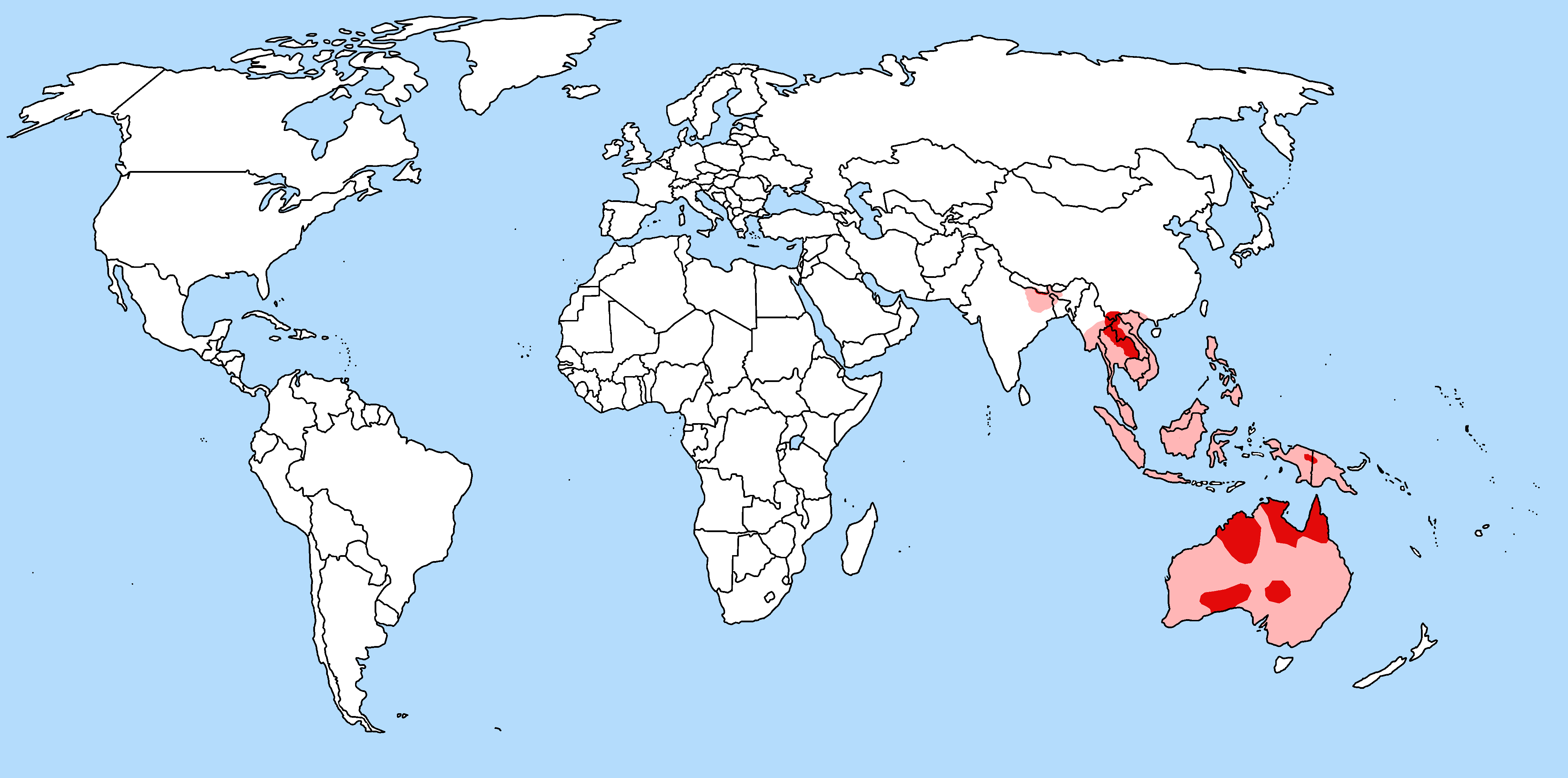
| Description | Geographic range of Canis lupus dingo with national borders added |
| Date | |
| Source | IUCN, Animal Diversity Web, and more |
| Author | TBjornstad 10:57, 15 July 2006 (UTC) |
| Permission (Reusing this file) |
Public Domain |
| Other versions | Image:Dingo-map-2.png |
The pinky colour indicate areas of crossbreeding uncertainty.
Licensing[edit]
| I, the copyright holder of this work, release this work into the public domain. This applies worldwide. In some countries this may not be legally possible; if so: I grant anyone the right to use this work for any purpose, without any conditions, unless such conditions are required by law. |
File history
Click on a date/time to view the file as it appeared at that time.
| Date/Time | Thumbnail | Dimensions | User | Comment | |
|---|---|---|---|---|---|
| current | 23:15, 25 March 2018 | | 4,500 × 2,234 (259 KB) | Maphobbyist (talk | contribs) | Montenegro and South Sudan borders |
| 09:37, 25 July 2008 |  | 4,500 × 2,234 (105 KB) | ToB (talk | contribs) | Added info about the Indian Santal Dog | |
| 06:43, 21 August 2006 |  | 4,500 × 2,234 (104 KB) | ToB (talk | contribs) | Revision regarding the area of pure Boran dogs in Thailand | |
| 10:57, 15 July 2006 |  | 4,500 × 2,234 (103 KB) | ToB (talk | contribs) | {{Information |Description=Geographic range of the Dingo (''Canis lupus dingo'') |Source=IUCN, Animal Diversity Web, and more |Date=July 15th 2006 |Author=~~~~ |Permission=Public Domain |other_versions=None }} The pinky colour indicate areas of crossbree |
You cannot overwrite this file.
File usage on Commons
The following page uses this file:
File usage on other wikis
The following other wikis use this file:
- Usage on af.wikipedia.org
- Usage on be-tarask.wikipedia.org
- Usage on bn.wikipedia.org
- Usage on eml.wikipedia.org
- Usage on en.wikipedia.org
- Usage on eo.wikipedia.org
- Usage on es.wikipedia.org
- Usage on et.wikipedia.org
- Usage on fa.wikipedia.org
- Usage on fr.wikipedia.org
- Usage on he.wikipedia.org
- Usage on hy.wikipedia.org
- Usage on id.wikipedia.org
- Usage on it.wikipedia.org
- Usage on ja.wikipedia.org
- Usage on ka.wikipedia.org
- Usage on kk.wikipedia.org
- Usage on lv.wikipedia.org
- Usage on ml.wikipedia.org
- Usage on mn.wikipedia.org
- Usage on nl.wikipedia.org
- Usage on nv.wikipedia.org
- Usage on pt.wikipedia.org
- Usage on sr.wikipedia.org
- Usage on ta.wikipedia.org
- Usage on th.wikipedia.org
- Usage on tl.wikipedia.org
- Usage on uk.wikipedia.org
- Usage on vi.wikipedia.org
- Usage on www.wikidata.org
- Usage on xmf.wikipedia.org
- Usage on zh-min-nan.wikipedia.org