File:East Wallabi Island.jpg
Vai alla navigazione
Vai alla ricerca

Dimensioni di questa anteprima: 730 × 600 pixel. Altre risoluzioni: 292 × 240 pixel | 584 × 480 pixel | 935 × 768 pixel | 1 111 × 913 pixel.
File originale (1 111 × 913 pixel, dimensione del file: 51 KB, tipo MIME: image/jpeg)
Didascalie
Didascalie
Aggiungi una brevissima spiegazione di ciò che questo file rappresenta
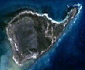
| Descrizione | This is a satellite image of East Wallabi Island in the Houtman Abrolhos. | |||
| Data | Created on 2007-11-21; not sure when the satellite image was collected. | |||
| Fonte | It was made with NASA World Wind using Landsat 7 data. | |||
| Autore | It was created by Hesperian. Any IP involved in the creation of this image is released into the public domain. | |||
| Licenza (Riusare questo file) |
|

Cronologia del file
Fare clic su un gruppo data/ora per vedere il file come si presentava nel momento indicato.
| Data/Ora | Miniatura | Dimensioni | Utente | Commento | |
|---|---|---|---|---|---|
| attuale | 11:40, 21 nov 2007 | | 1 111 × 913 (51 KB) | Hesperian (discussione | contributi) | {{Information |Description=This is a satellite image of East Wallabi Island in the Houtman Abrolhos. |Source=It was made with NASA World Wind using Landsat 7 data. |Date=Created on 2007-11-21; not sure when the satellite image was collected. |Aut |
Impossibile sovrascrivere questo file.
Utilizzo del file
Nessuna pagina utilizza questo file.
Utilizzo globale del file
Anche i seguenti wiki usano questo file:
- Usato nelle seguenti pagine di arz.wikipedia.org:
- Usato nelle seguenti pagine di ceb.wikipedia.org:
- Usato nelle seguenti pagine di en.wikipedia.org:
- Usato nelle seguenti pagine di it.wikipedia.org:
- Usato nelle seguenti pagine di sv.wikipedia.org:
- Usato nelle seguenti pagine di www.wikidata.org: