File:Eldfell, Helgafell and the fissure.jpg
Jump to navigation
Jump to search
No higher resolution available.
Eldfell,_Helgafell_and_the_fissure.jpg (450 × 294 pixels, file size: 47 KB, MIME type: image/jpeg)
Captions
Captions
Add a one-line explanation of what this file represents
Summary[edit]
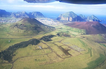
| Description | The island of Heimaey, with Helgafell at the left and Eldfell on the right. The extent of the 1973 eruption fissure south of Eldfell is visible. |
| Source | http://iceland.world-traveller.org iceland.world-traveller.org |
| Author | en:User:Worldtraveller |
| Permission (Reusing this file) |
GFDL |
Licensing[edit]
| This file is licensed under the Creative Commons Attribution-Share Alike 3.0 Unported license. Subject to disclaimers. | ||
| ||
| This licensing tag was added to this file as part of the GFDL licensing update. |

|
Permission is granted to copy, distribute and/or modify this document under the terms of the GNU Free Documentation License, Version 1.2 or any later version published by the Free Software Foundation; with no Invariant Sections, no Front-Cover Texts, and no Back-Cover Texts. A copy of the license is included in the section entitled GNU Free Documentation License. Subject to disclaimers. |
| Annotations | This image is annotated: View the annotations at Commons |
File history
Click on a date/time to view the file as it appeared at that time.
| Date/Time | Thumbnail | Dimensions | User | Comment | |
|---|---|---|---|---|---|
| current | 18:22, 11 May 2006 | | 450 × 294 (47 KB) | Wirthi (talk | contribs) | {{Information| |Description=The island of Heimaey, with Helgafell at the left and Eldfell on the right. The extent of the 1973 eruption fissure south of Eldfell is clearly seen. |Source=http://iceland.world-traveller.org iceland.world-traveller.org |Date= |
You cannot overwrite this file.
File usage on Commons
There are no pages that use this file.
File usage on other wikis
The following other wikis use this file:
- Usage on af.wikipedia.org
- Usage on az.wikipedia.org
- Usage on be.wikipedia.org
- Usage on ceb.wikipedia.org
- Usage on cs.wikipedia.org
- Usage on da.wikipedia.org
- Usage on de.wikipedia.org
- Usage on en.wikipedia.org
- Usage on en.wikivoyage.org
- Usage on fr.wikipedia.org
- Usage on he.wikipedia.org
- Usage on hu.wikipedia.org
- Usage on is.wikibooks.org
- Usage on ja.wikipedia.org
- Usage on nl.wikipedia.org
- Usage on nn.wikipedia.org
- Usage on no.wikipedia.org
- Usage on pl.wikipedia.org
- Usage on ru.wikipedia.org
- Usage on sk.wikipedia.org
- Usage on sv.wikipedia.org
- Usage on tr.wikipedia.org
- Usage on uk.wikipedia.org