File:English ceremonial counties 2010.svg
קפיצה לניווט
קפיצה לחיפוש

גודל התצוגה המקדימה הזאת מסוג PNG של קובץ ה־SVG הזה: 494 × 600 פיקסלים. רזולוציות אחרות: 198 × 240 פיקסלים | 395 × 480 פיקסלים | 633 × 768 פיקסלים | 843 × 1,024 פיקסלים | 1,687 × 2,048 פיקסלים | 1,108 × 1,345 פיקסלים.
לקובץ המקורי (קובץ SVG, הגודל המקורי: 1,108 × 1,345 פיקסלים, גודל הקובץ: 302 ק"ב)
כיתובים
כיתובים
נא להוסיף משפט שמסביר מה הקובץ מייצג
תקציר
[עריכה]
.svg)
.svg)
.svg)
.svg)
.svg)
.svg)
.svg)
.svg)
.svg)
.svg)
רישיון
[עריכה]
אני, בעל זכויות היוצרים על היצירה הזאת, מפרסם אותה בזאת תחת הרישיונות הבאים:
הקובץ הזה מתפרסם לפי תנאי רישיון קריאייטיב קומונז ייחוס-שיתוף זהה 3.0 לא מותאם.
- הנכם רשאים:
- לשתף – להעתיק, להפיץ ולהעביר את העבודה
- לערבב בין עבודות – להתאים את העבודה
- תחת התנאים הבאים:
- ייחוס – יש לתת ייחוס הולם, לתת קישור לרישיון, ולציין אם נעשו שינויים. אפשר לעשות את זה בכל צורה סבירה, אבל לא בשום צורה שמשתמע ממנה שמעניק הרישיון תומך בך או בשימוש שלך.
- שיתוף זהה – אם תיצרו רמיקס, תשנו, או תבנו על החומר, חובה עליכם להפיץ את התרומות שלך לפי תנאי רישיון זהה או תואם למקור.

|
מוענקת בכך הרשות להעתיק, להפיץ או לשנות את המסמך הזה, לפי תנאי הרישיון לשימוש חופשי במסמכים של גנו, גרסה 1.2 או כל גרסה מאוחרת יותר שתפורסם על־ידי המוסד לתוכנה חופשית; ללא פרקים קבועים, ללא טקסט עטיפה קדמית וללא טקסט עטיפה אחורית. עותק של הרישיון כלול בפרק שכותרתו הרישיון לשימוש חופשי במסמכים של גנו. |
הנכם מוזמנים לבחור את הרישיון הרצוי בעיניכם.
היסטוריית הקובץ
ניתן ללחוץ על תאריך/שעה כדי לראות את הקובץ כפי שנראה באותו זמן.
| תאריך/שעה | תמונה ממוזערת | ממדים | משתמש | הערה | |
|---|---|---|---|---|---|
| נוכחית | 16:39, 23 בנובמבר 2010 | | 1,345 × 1,108 (302 ק"ב) | Nilfanion (שיחה | תרומות) | thicker lines |
| 16:20, 23 בנובמבר 2010 |  | 1,345 × 1,108 (294 ק"ב) | Nilfanion (שיחה | תרומות) | tweaks | |
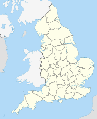
| 20:34, 26 באוקטובר 2010 |  | 990 × 817 (1.33 מ"ב) | Nilfanion (שיחה | תרומות) | {{Information |Description=Map showing the w:ceremonial counties of England including the City of London, in 2010. Equirectangular map projection on WGS 84 datum, with N/S stretched 170% Geographic limits: *West: 6.75W *East: 2.0E *North: 56.0N *Sou |
אין באפשרותך לדרוס את הקובץ הזה.
שימוש בקובץ
הדפים הבאים משתמשים בקובץ הזה:
- User:Nilfanion/Maps
- User:Nilfanion/Maps/National
- File:East Midlands counties 00.png
- File:East Midlands counties 2009 map.svg
- File:East of England counties 2009 map.svg
- File:English Football Conference county coverage.png
- File:English administrative counties 1889 (numbered).svg
- File:English administrative counties 1965 (numbered).svg
- File:English ceremonial counties 1997.svg
- File:English ceremonial counties 1998.svg
- File:English ceremonial counties 1998 (named).svg
- File:English ceremonial counties 1998 (numbered).svg
- File:English counties 1851.svg
- File:English counties 1851 (named).svg
- File:English counties 1851 (numbered).svg
- File:English counties 1851 with ridings.svg
- File:English county tops map.svg
- File:English geographical counties 1889.svg
- File:English geographical counties 1889 (named).svg
- File:English geographical counties 1889 with ridings.svg
- File:English geographical counties 1889 with ridings (numbered).svg
- File:English geographical counties 1965.svg
- File:English geographical counties 1965 (named).svg
- File:English geographical counties 1965 with ridings.svg
- File:English non-metropolitan districts 2009.svg
- File:English non-metropolitan districts 2019.jpg
- File:Miss Grand UK 2021 - England's participated counties.svg
- File:NUTS 3 regions of North East England map.svg
- File:NUTS 3 regions of North West England 2010 map.svg
- File:NUTS 3 regions of North West England 2015 map.svg
- File:NUTS 3 regions of North West England map.svg
- File:NUTS 3 regions of South East England 2015 map.svg
- File:NUTS 3 regions of South East England map.svg
- File:NUTS 3 regions of South West England map.svg
- File:NUTS 3 regions of Yorkshire and the Humber 2010 map.svg
- File:NUTS 3 regions of Yorkshire and the Humber map.svg
- File:NUTS 3 regions of the East Midlands 2010 map.svg
- File:NUTS 3 regions of the East Midlands map.svg
- File:NUTS 3 regions of the East of England 2010 map.svg
- File:NUTS 3 regions of the East of England 2015 map.svg
- File:NUTS 3 regions of the East of England map.svg
- File:NUTS 3 regions of the West Midlands 2010 map.svg
- File:NUTS 3 regions of the West Midlands map.svg
- File:North East England counties 2.2.png
- File:North East England counties 2009 map.svg
- File:North West England counties.png
- File:North West England counties 2009 map.svg
- File:Northumberland and County Durham location map.svg
- File:SouthWest-local-government-2019.jpg
- File:South East England counties.png
- File:South East England counties 2009 map.svg
- File:South West England counties.png
- File:South West England counties 2009 map.svg
- File:West Midlands counties.png
- File:West Midlands counties 2009 map.svg
- File:Yorkshire & The Humber counties.png
- File:Yorkshire UK 1851 locator map.svg
- File:Yorkshire and the Humber counties 2009 map.svg
שימוש גלובלי בקובץ
אתרי הוויקי השונים הבאים משתמשים בקובץ זה:
- שימוש באתר en.wikipedia.org
- שימוש באתר ja.wikibooks.org