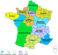
File:FR-Régions.svg
From Wikimedia Commons, the free media repository
Jump to navigation
Jump to search

Size of this PNG preview of this SVG file: 463 × 436 pixels. Other resolutions: 255 × 240 pixels | 510 × 480 pixels | 816 × 768 pixels | 1,087 × 1,024 pixels | 2,175 × 2,048 pixels.
Original file (SVG file, nominally 463 × 436 pixels, file size: 354 KB)
File information
Structured data
Captions
Captions
Add a one-line explanation of what this file represents
Summary
[edit]| DescriptionFR-Régions.svg |
Français : Carte administrative des régions, collectivités territoriales françaises. , créée sous Inkscape 0.92 |
| Date | |
| Source |
This file was derived from: Cantonales 2011.svg |
| Author | Roland45 |
Licensing
[edit]I, the copyright holder of this work, hereby publish it under the following license:
This file is licensed under the Creative Commons Attribution-Share Alike 4.0 International license.
- You are free:
- to share – to copy, distribute and transmit the work
- to remix – to adapt the work
- Under the following conditions:
- attribution – You must give appropriate credit, provide a link to the license, and indicate if changes were made. You may do so in any reasonable manner, but not in any way that suggests the licensor endorses you or your use.
- share alike – If you remix, transform, or build upon the material, you must distribute your contributions under the same or compatible license as the original.
File history
Click on a date/time to view the file as it appeared at that time.
| Date/Time | Thumbnail | Dimensions | User | Comment | |
|---|---|---|---|---|---|
| current | 07:00, 17 October 2019 |  | 463 × 436 (354 KB) | Roland45 (talk | contribs) | Correction Occitanie |
| 06:58, 17 October 2019 |  | 463 × 436 (354 KB) | Roland45 (talk | contribs) | Correction erreur Grand Est | |
| 08:43, 24 May 2019 |  | 463 × 436 (354 KB) | Roland45 (talk | contribs) | correction Territoire de Belfort en Bourgogne-Franche-Comté | |
| 13:24, 23 May 2019 |  | 463 × 436 (354 KB) | Roland45 (talk | contribs) | Couleurs à Guadeloupe et La Réunion | |
| 18:10, 22 May 2019 |  | 463 × 436 (354 KB) | Roland45 (talk | contribs) | Textes vectorisés | |
| 17:59, 22 May 2019 |  | 463 × 436 (238 KB) | Roland45 (talk | contribs) | == {{int:filedesc}} == =={{int:filedesc}}== {{Information |description={{fr|1=Carte administrative des drégions, collectivités territoriales françaises.}} , créée sous [http://www.inkscape.org/ Inkscape] 0.92 |date=2019-05-22 |source={{derived from|Cantonales 2011.svg }} |author=Roland45 |permission= |other versions= }} =={{int:license-header}}== {{self|cc-by-sa-4.0}} Category:SVG political maps of France Category:SVG maps of regions of France |
You cannot overwrite this file.
File usage on Commons
There are no pages that use this file.
File usage on other wikis
The following other wikis use this file:
- Usage on fr.wikipedia.org
- Centre-Val de Loire
- Corse
- France
- Île-de-France
- Pays de la Loire
- Région française
- Guyane
- La Réunion
- Polynésie française
- Saint-Pierre-et-Miquelon
- Mayotte
- Eure (département)
- Îles Kerguelen
- Île Clipperton
- France d'outre-mer
- Projet:Géographie/Palettes de navigation
- Îles Éparses de l'océan Indien
- Catégorie:Région en France
- Antilles françaises
- Collectivité d'outre-mer
- Archipel Crozet
- Île Europa
- Terre Adélie
- Organisation territoriale de la France
- Portail:France/modèles
- Discussion utilisateur:ArnoLagrange/Archive 2004
- Province des îles Loyauté
- Bassas da India
- Bretagne (région administrative)
- Îles Saint-Paul et Amsterdam
- Île Amsterdam
- Île Saint-Paul (océan Indien)
- Île Juan de Nova
- Îles Glorieuses
- Province Nord (Nouvelle-Calédonie)
- Noms des habitants des territoires de la France d'outre-mer
- Nouvelle-Calédonie
- Province Sud (Nouvelle-Calédonie)
- Saint-Martin (Antilles françaises)
- Île aux Cochons
- Île des Pingouins
- Îlots des Apôtres
- Île de la Possession
- Île de l'Est
- Département et région d'outre-mer
- Saint-Barthélemy (Antilles françaises)
- Provence-Alpes-Côte d'Azur
- Orne (département)
- Catégorie:Région d'outre-mer
- Île Tromelin
View more global usage of this file.
Metadata
This file contains additional information such as Exif metadata which may have been added by the digital camera, scanner, or software program used to create or digitize it. If the file has been modified from its original state, some details such as the timestamp may not fully reflect those of the original file. The timestamp is only as accurate as the clock in the camera, and it may be completely wrong.
| Width | 462.5px |
|---|---|
| Height | 436.25px |