File:Falkland Islands location map.svg
קפיצה לניווט
קפיצה לחיפוש

גודל התצוגה המקדימה הזאת מסוג PNG של קובץ ה־SVG הזה: 737 × 600 פיקסלים. רזולוציות אחרות: 295 × 240 פיקסלים | 590 × 480 פיקסלים | 944 × 768 פיקסלים | 1,258 × 1,024 פיקסלים | 2,516 × 2,048 פיקסלים | 1,134 × 923 פיקסלים.
לקובץ המקורי (קובץ SVG, הגודל המקורי: 1,134 × 923 פיקסלים, גודל הקובץ: 138 ק"ב)
כיתובים
כיתובים
נא להוסיף משפט שמסביר מה הקובץ מייצג
תקציר[עריכה]
| תיאור |
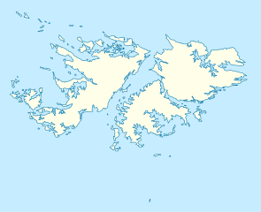
Deutsch: Positionskarte der Falklandinseln
Quadratische Plattkarte, N-S-Streckung 155 %. Geographische Begrenzung der Karte:
English: Location map of the Falkland Islands
Equirectangular projection, N/S stretching 155 %. Geographic limits of the map:
|
|||||||||
| תאריך יצירה | ||||||||||
| מקור | own work, using United States National Imagery and Mapping Agency data | |||||||||
| יוצר | ||||||||||
| Geotemporal data | ||||||||||
| Bounding box |
|
|||||||||
| Georeferencing | If inappropriate please set warp_status = skip to hide. | |||||||||
| גרסאות אחרות |
Derivative works of this file: |
|||||||||

|
This map has been made or improved in the German Kartenwerkstatt (Map Lab). You can propose maps to improve as well.
|
רישיון[עריכה]
אני, בעל זכויות היוצרים על היצירה הזאת, מפרסם אותה בזאת תחת הרישיונות הבאים:

|
מוענקת בכך הרשות להעתיק, להפיץ או לשנות את המסמך הזה, לפי תנאי הרישיון לשימוש חופשי במסמכים של גנו, גרסה 1.2 או כל גרסה מאוחרת יותר שתפורסם על־ידי המוסד לתוכנה חופשית; ללא פרקים קבועים, ללא טקסט עטיפה קדמית וללא טקסט עטיפה אחורית. עותק של הרישיון כלול בפרק שכותרתו הרישיון לשימוש חופשי במסמכים של גנו. |
הקובץ הזה מתפרסם לפי תנאי רישיון קריאייטיב קומונז ייחוס 3.0 לא מותאם.
- הנכם רשאים:
- לשתף – להעתיק, להפיץ ולהעביר את העבודה
- לערבב בין עבודות – להתאים את העבודה
- תחת התנאים הבאים:
- ייחוס – יש לתת ייחוס הולם, לתת קישור לרישיון, ולציין אם נעשו שינויים. אפשר לעשות את זה בכל צורה סבירה, אבל לא בשום צורה שמשתמע ממנה שמעניק הרישיון תומך בך או בשימוש שלך.
הנכם מוזמנים לבחור את הרישיון הרצוי בעיניכם.
היסטוריית הקובץ
ניתן ללחוץ על תאריך/שעה כדי לראות את הקובץ כפי שנראה באותו זמן.
| תאריך/שעה | תמונה ממוזערת | ממדים | משתמש | הערה | |
|---|---|---|---|---|---|
| נוכחית | 12:00, 15 במרץ 2009 | | 923 × 1,134 (138 ק"ב) | NordNordWest (שיחה | תרומות) | {{Information |Description= {{de|Positionskarte der Falklandinseln}} Quadratische Plattkarte, N-S-Streckung 155 %. Geographische Begrenzung der Karte: * N: 50.9° S * S: 53.0° S * W: 61.5° W * O: 57.5° W {{en|Location map of the |
אין באפשרותך לדרוס את הקובץ הזה.
שימוש בקובץ
הדפים הבאים משתמשים בקובץ הזה:
- User:Camilo Sanchez/gallery
- User:NordNordWest/Gallery/Location maps
- File:Falkland Islands on the globe (zoom) (Chile centered).svg
- File:Malvinas spanish locations.svg
- File:Relief Map of Falkland Islands.png
- File:States and territories of Americas.svg
- File:United Kingdom (overseas+crown dependencies), administrative divisions - Nmbrs (marker).svg
- File:United Kingdom (overseas+crown dependencies), administrative divisions - Nmbrs (multiple zoom).svg
- File:United Kingdom (overseas+crown dependencies), administrative divisions - Nmbrs (single zoom).svg
- File:United Kingdom (overseas+crown dependencies), administrative divisions - de (marker).svg
- File:United Kingdom (overseas+crown dependencies), administrative divisions - de (multiple zoom).svg
- File:United Kingdom (overseas+crown dependencies), administrative divisions - de (single zoom).svg
- File:United Kingdom (overseas-crown dependencies), administrative divisions - Nmbrs (marker).svg
- File:United Kingdom (overseas-crown dependencies), administrative divisions - Nmbrs (multiple zoom).svg
- File:United Kingdom (overseas-crown dependencies), administrative divisions - Nmbrs (single zoom).svg
- File:United Kingdom (overseas-crown dependencies), administrative divisions - de (marker).svg
- File:United Kingdom (overseas-crown dependencies), administrative divisions - de (multiple zoom).svg
- File:United Kingdom (overseas-crown dependencies), administrative divisions - de (single zoom).svg
_(Chile_centered).svg)
,_administrative_divisions_-_Nmbrs_(marker).svg)
,_administrative_divisions_-_Nmbrs_(multiple_zoom).svg)
,_administrative_divisions_-_Nmbrs_(single_zoom).svg)
,_administrative_divisions_-_de_(marker).svg)
,_administrative_divisions_-_de_(multiple_zoom).svg)
,_administrative_divisions_-_de_(single_zoom).svg)
שימוש גלובלי בקובץ
אתרי הוויקי השונים הבאים משתמשים בקובץ זה:
- שימוש באתר af.wikipedia.org
- שימוש באתר an.wikipedia.org
- שימוש באתר ar.wikipedia.org
- שימוש באתר ast.wikipedia.org
- שימוש באתר az.wikipedia.org
- שימוש באתר ba.wikipedia.org
- שימוש באתר be-tarask.wikipedia.org
- שימוש באתר be.wikipedia.org
- שימוש באתר bg.wikipedia.org
- שימוש באתר bn.wikipedia.org
- שימוש באתר ca.wikipedia.org
- שימוש באתר ceb.wikipedia.org
- Plantilya:Location map United Kingdom Falkland Islands
- William Point
- Sandy Island
- Saddle Hill
- Rat Island
- Rabbit Island
- Low Bay
- Long Island
- Green Island
- Green Islet
- Goat Point
- Castle Hill
- Bird Island
- Mount Pleasant
- North Point
- Hospital Point
- Castle Rock
- West Point
- Little Island
- Black Point
- North Beach
- Sail Rock
- Black Rock
- High Rock
- Hut Point
- East Point
- Wolf Rock
- White Rock
- White Point
- Whale Point
צפייה בשימושים גלובליים נוספים של קובץ זה.