File:Flooding in pakistan-NASA satellite imagery.jpg
Jump to navigation
Jump to search
No higher resolution available.
Flooding_in_pakistan-NASA_satellite_imagery.jpg (720 × 480 pixels, file size: 169 KB, MIME type: image/jpeg)
Captions
Captions
Add a one-line explanation of what this file represents
Summary[edit]
| Description |
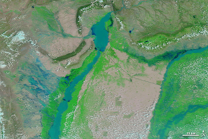
English: The image shows the Indus river in northwestern Pakistan. The satellite picture uses a combination of infrared and visible light to increase the contrast between the flood water and land. This better shows the extent of the flooding than a normal satellite or aerial picture would. Water varies in colour from electric blue to navy. Vegetation is green and bare ground is pinkish brown. The nearly white to pale blue-green range is clouds. This image clearly shows the extent of the flooding from the monsoon rains. |
| Date | |
| Source | NASA’s Terra satellite - ("http://earthobservatory.nasa.gov/IOTD/view.php?id=44991") |
| Author | NASA Earth Observatory |
Licensing[edit]
| This file is in the public domain in the United States because it was solely created by NASA. NASA copyright policy states that "NASA material is not protected by copyright unless noted". (See Template:PD-USGov, NASA copyright policy page or JPL Image Use Policy.) | ||
 |
Warnings:
|
| Annotations | This image is annotated: View the annotations at Commons |
File history
Click on a date/time to view the file as it appeared at that time.
| Date/Time | Thumbnail | Dimensions | User | Comment | |
|---|---|---|---|---|---|
| current | 16:42, 6 August 2010 | | 720 × 480 (169 KB) | FireLyte--spyre (talk | contribs) | {{Information |Description={{en|1=The image shows the Indus river in northwestern Pakistan. The satellite picture uses a combination of infrared and visible light to increase the contrast between the flood water and land. This better shows the extent of t |
You cannot overwrite this file.
File usage on Commons
There are no pages that use this file.
File usage on other wikis
The following other wikis use this file:
- Usage on en.wikinews.org