File:FreggioAndPratoSpiralTunnelsBetweenRodi-FiessoAndFaidoStationsOnSouthernRampToGotthardTunnel.jpg
File originale (1 403 × 491 pixel, dimensione del file: 76 KB, tipo MIME: image/jpeg)
Didascalie
Didascalie
Dettagli
[modifica]
| Descrizione |
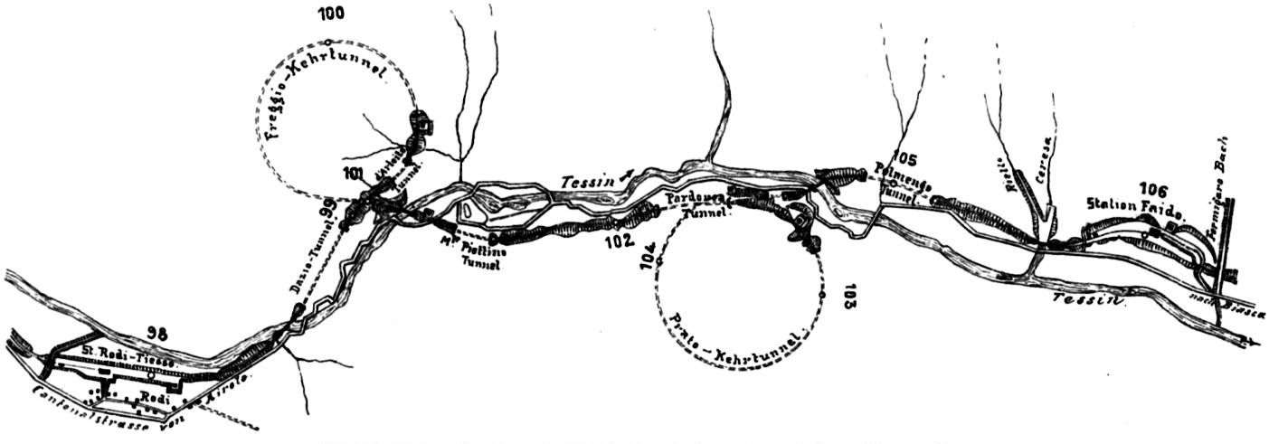
English: Outline of the Freggio and Prato spiral tunnels between the Rodi-Fiesso and Faido stations on the southern ramp to the Gotthard tunnel. Going down the southern ramp of the Gotthardbahn after the Gotthard Tunnel the line passes the station of Rodi-Fiesso in a 90° left turn, crosses to the left side of the Ticino River (Tessin) valley. There it passes the 270° Freggio Spiral Tunnel in a left turn into the left side of the valley. Leaving the tunnel the line crosses again the Ticino River valley to proceed a kilometer on the right valley side before moving through the 360° Prato Spiral Tunnel in a right turn into the right valley side. Exiting the tunnel the line crosses again to the left valley side bridging smaller streams before passing through the Faido station and continuing the decent down the southern ramp. |
||||
| Data | 1914, book (or prior source predating the publication of volume 5 of Röll's encyclopedia in 1914) | ||||
| Fonte | Gotthardbahn in Röll, V. Freiherr von: Enzyklopädie des Eisenbahnwesens, Band 5. Berlin, Wien 1914, p. 356 and 357 digitized version on www.zeno.org/Roell-1912 | ||||
| Autore | Dietler, Hermann (1839-10-01 - 1924-01-24); Röll, Victor Freiherr von (1852-05-22 - 1922-10-12) | ||||
| Licenza (Riusare questo file) |
|
||||
The original German caption of the graph in the cited publication reads "Abb. 290. Linienentwicklung bei Dazio Grande (Ferggio- und Prato-Kehrtunnel)."
No scale or legend was provided with the map other than the travel distance along the Gotthard line from Immensee indicated for each full kilometer by a small circular mark and the specified distance in km. A hight information is also not provided.
Some of the notations on the map are hard to resolve and prone to be misread or misinterpreted. This includes, but is not limited to the two station names and the name of one of the spiral tunnels, which are the more prominent features marked in larger letter type compared to others. Here the correct name is used with a possible misinterpretation shown in brackets and in the case of the two stations their travel distance from Immensee as interpreted from the data provided in the map:
Rodi-Fiesso Station (Rodi-Tiesso) 97.8km
Faido Station (F??ido) 106.0km
Prato Kehrtunnel (Prxte Kehrtunnel)
These distances match the ones currently listed for the stations in the route diagramm of the Gotthardbahn. Tessin is the Ticino River.
Licenza
[modifica]
|
Quest'opera è nel pubblico dominio anche in tutti i Paesi e nelle aree in cui la durata del copyright è la vita dell'autore più 70 anni o meno.
| |
| Questo file è stato identificato come libero da restrizioni conosciute riguardanti le leggi sul copyright, compresi tutti i diritti connessi e vicini. | |
Cronologia del file
Fare clic su un gruppo data/ora per vedere il file come si presentava nel momento indicato.
| Data/Ora | Miniatura | Dimensioni | Utente | Commento | |
|---|---|---|---|---|---|
| attuale | 18:05, 18 ago 2009 | 1 403 × 491 (76 KB) | PasoAPaso (discussione | contributi) | {{Information |Description={{en|1=Outline of the Freggio and Prato spiral tunnels between the Rodi-Fiesso and Faido stations on the southern ramp to the Gotthard tunnel.<br> Going down the southern ramp of the {{w|Gotthard Line|Gotthardbahn}} after the { |
Impossibile sovrascrivere questo file.
Utilizzo del file
Nessuna pagina utilizza questo file.
Utilizzo globale del file
Anche i seguenti wiki usano questo file:
- Usato nelle seguenti pagine di de.wikipedia.org:
- Usato nelle seguenti pagine di en.wikipedia.org:
- Usato nelle seguenti pagine di fr.wikipedia.org:
- Usato nelle seguenti pagine di it.wikipedia.org:
- Usato nelle seguenti pagine di nl.wikipedia.org:
- Usato nelle seguenti pagine di pt.wikipedia.org:
- Usato nelle seguenti pagine di ro.wikipedia.org: