File:Fruehe.phoenizische.Handelswege.png

Original file (1,252 × 866 pixels, file size: 195 KB, MIME type: image/png)
Captions
Captions
Summary[edit]
| DescriptionFruehe.phoenizische.Handelswege.png |
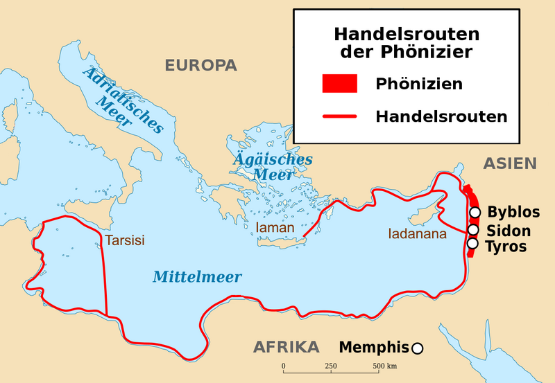
Deutsch: Die Karte zeigt die mutmaßlich frühen Seehandelswege der Phönizier im Mittelmeerraum. In der Anfangszeit der phönizischen Seefahrt wurden aus Sicherheitsgründen und wegen der einfacheren Navigation vermutlich nur die küstennahen Regionen befahren, so dass nur Zypern (Iadanana), Rhodos und Kreta (Iaman) sowie über die nordafrikanische Küste bis zum erst im späten 9. Jahrhundert vor Christus gegründete Karthago nur die Inseln Malta und Sizilien (Tarsisi) zu den erreichbaren bedeutenden Inseln gezählt haben dürften. Der König Asarhaddon (7. vorchristliches Jahrhundert) aus dem Assyrischen Reich in Mesopotamien hatte die Inselkönigreiche Iadanana, Iaman und Tarsisi unterworfen. |
| Date | |
| Source | Own work |
| Author | Bautsch |
Licensing[edit]
| This file is made available under the Creative Commons CC0 1.0 Universal Public Domain Dedication. | |
| The person who associated a work with this deed has dedicated the work to the public domain by waiving all of their rights to the work worldwide under copyright law, including all related and neighboring rights, to the extent allowed by law. You can copy, modify, distribute and perform the work, even for commercial purposes, all without asking permission.
http://creativecommons.org/publicdomain/zero/1.0/deed.enCC0Creative Commons Zero, Public Domain Dedicationfalsefalse |
File history
Click on a date/time to view the file as it appeared at that time.
| Date/Time | Thumbnail | Dimensions | User | Comment | |
|---|---|---|---|---|---|
| current | 09:37, 23 May 2022 |  | 1,252 × 866 (195 KB) | Bautsch (talk | contribs) | Uploaded own work with UploadWizard |
You cannot overwrite this file.
File usage on Commons
There are no pages that use this file.
File usage on other wikis
The following other wikis use this file:
- Usage on de.wikibooks.org
Metadata
This file contains additional information such as Exif metadata which may have been added by the digital camera, scanner, or software program used to create or digitize it. If the file has been modified from its original state, some details such as the timestamp may not fully reflect those of the original file. The timestamp is only as accurate as the clock in the camera, and it may be completely wrong.
| Horizontal resolution | 37.79 dpc |
|---|---|
| Vertical resolution | 37.79 dpc |