File:Global Landslide Risks.jpg
Jump to navigation
Jump to search
No higher resolution available.
Global_Landslide_Risks.jpg (540 × 320 pixels, file size: 58 KB, MIME type: image/jpeg)
Captions
Captions
Add a one-line explanation of what this file represents
Summary[edit]
| Description |
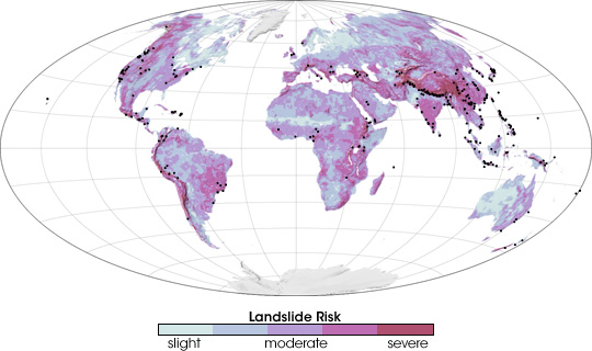
English: Scientists are striving to reduce the loss of life from landslides by developing a global, satellite-based early-warning system. The scientists first identified landslide-prone regions, as shown in this image. To create this landslide risk map scientists mapped all of the regions that featured some combination of coarse soil, land cover that was inadequate to stabilize the surface, and/or steep mountains. The regions that have the highest risk of landslides are salmon pink. Areas of moderate risk are lavender, and regions with a slight risk are pale blue. Areas where landslides occurred between 2003 and 2006 are marked with black dots on this map. |
| Date | |
| Source | http://earthobservatory.nasa.gov/IOTD/view.php?id=7783 |
| Author | Robert Simmon |
Based on measurements recorded by the Tropical Rainfall Measuring Mission (TRMM) satellite.
Licensing[edit]
| This file is in the public domain in the United States because it was solely created by NASA. NASA copyright policy states that "NASA material is not protected by copyright unless noted". (See Template:PD-USGov, NASA copyright policy page or JPL Image Use Policy.) | ||
 |
Warnings:
|
File history
Click on a date/time to view the file as it appeared at that time.
| Date/Time | Thumbnail | Dimensions | User | Comment | |
|---|---|---|---|---|---|
| current | 20:31, 5 July 2009 | | 540 × 320 (58 KB) | Originalwana (talk | contribs) | {{Information |Description={{en|1=Scientists are striving to reduce the loss of life from landslides by developing a global, satellite-based early-warning system. The scientists first identified landslide-prone regions, as shown in this image. To create t |
You cannot overwrite this file.
File usage on Commons
The following page uses this file:
File usage on other wikis
The following other wikis use this file:
- Usage on en.wikipedia.org
- Usage on hu.wikipedia.org
- Usage on ja.wikipedia.org
- Usage on kn.wikipedia.org
- Usage on ta.wikipedia.org
- Usage on www.wikidata.org