File:Golfstrom Karte 2.png
Jump to navigation
Jump to search
No higher resolution available.
Golfstrom_Karte_2.png (649 × 544 pixels, file size: 143 KB, MIME type: image/png)
Captions
Captions
Add a one-line explanation of what this file represents

|
This meteorology image could be re-created using vector graphics as an SVG file. This has several advantages; see Commons:Media for cleanup for more information. If an SVG form of this image is available, please upload it and afterwards replace this template with
{{vector version available|new image name}}.
It is recommended to name the SVG file “Golfstrom Karte 2.svg”—then the template Vector version available (or Vva) does not need the new image name parameter. |
Summary[edit]
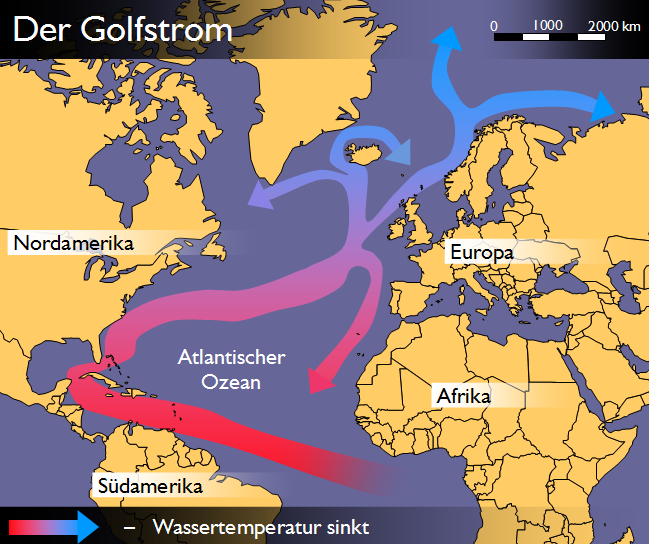
- Schematische Darstellung des Golfstroms
- Karte wurde selbst erstellt
Bemerkung[edit]
Nach den vielen Verbesserungsvorschlägen habe ich das Farb- und Schriftdesign überarbeitet. Um auf eine bestimmte Bemerkung einzugehen, wo behauptet wurde, die Karte erinnere an eine Darstellung der BILD-Zeitung kann ich nur erwidern, dass die entsprechende Redaktion auf die von mir erstellte Karte zurückgegriffen hat, und nicht umgekehrt. -- WEBMASTER 21:47, 29. Jun 2006 (CEST)
Licensing[edit]

|
Permission is granted to copy, distribute and/or modify this document under the terms of the GNU Free Documentation License, Version 1.2 or any later version published by the Free Software Foundation; with no Invariant Sections, no Front-Cover Texts, and no Back-Cover Texts. A copy of the license is included in the section entitled GNU Free Documentation License. |
| This file is licensed under the Creative Commons Attribution-Share Alike 3.0 Unported license. | ||
| ||
| This licensing tag was added to this file as part of the GFDL licensing update. |
File history
Click on a date/time to view the file as it appeared at that time.
| Date/Time | Thumbnail | Dimensions | User | Comment | |
|---|---|---|---|---|---|
| current | 18:16, 1 December 2006 | | 649 × 544 (143 KB) | Nils Simon (talk | contribs) | == Beschreibung, Quelle == *Schematische Darstellung des Golfstroms *Karte wurde selbst erstellt == Bemerkung == Nach den vielen Verbesserungsvorschlägen habe ich das Farb- und Schriftdesign überarbeitet. Um auf eine bestimmte Bemerkung einzugehen, wo |
You cannot overwrite this file.
File usage on Commons
There are no pages that use this file.
File usage on other wikis
The following other wikis use this file:
- Usage on az.wikipedia.org
- Usage on be-tarask.wikipedia.org
- Usage on be.wikipedia.org
- Usage on ca.wikipedia.org
- Usage on da.wikipedia.org
- Usage on de.wikipedia.org
- Usage on en.wikipedia.org
- Usage on eo.wikipedia.org
- Usage on es.wikipedia.org
- Usage on et.wikipedia.org
- Usage on eu.wikipedia.org
- Usage on fa.wikipedia.org
- Usage on fr.wikipedia.org
- Usage on fy.wikipedia.org
- Usage on it.wikipedia.org
- Usage on ja.wikipedia.org
- Usage on km.wikipedia.org
- Usage on ku.wikipedia.org
- Usage on ky.wikipedia.org
- Usage on mk.wikipedia.org
- Usage on nl.wikipedia.org
- Usage on no.wikipedia.org
- Usage on uk.wikipedia.org
View more global usage of this file.