File:Guangzhou Metro Map.png
Jump to navigation
Jump to search

Size of this preview: 800 × 565 pixels. Other resolutions: 320 × 226 pixels | 640 × 452 pixels | 842 × 595 pixels.
Original file (842 × 595 pixels, file size: 90 KB, MIME type: image/png)
Captions
Captions
Add a one-line explanation of what this file represents

|
This transport map image could be re-created using vector graphics as an SVG file. This has several advantages; see Commons:Media for cleanup for more information. If an SVG form of this image is available, please upload it and afterwards replace this template with
{{vector version available|new image name}}.
It is recommended to name the SVG file “Guangzhou Metro Map.svg”—then the template Vector version available (or Vva) does not need the new image name parameter. |
Summary[edit]
English:
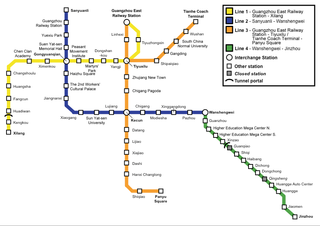
- Description: Map of the Guangzhou Metro as 28 June 2007
- Author: JROBBO
- Date: December 30, 2005 (original, updated 30 October 2007)
- Source: English Wikipedia
- License: Creative Commons Attribution ShareAlike Version 2.5
Deutsch:
- Beschreibung: Karte der Metro von Guangzhou (mit Gültigkeitsdatum 28.06.07)
- Autor: JROBBO
- Datum: 30. Dezember 2005 (30. Oktober 2007 aktualisiert)
- Quelle: Englische Wikipedia
- Lizenz: Creative Commons Attribution ShareAlike Version 2.5
Licensing[edit]
This file is licensed under the Creative Commons Attribution-Share Alike 2.5 Generic license.
- You are free:
- to share – to copy, distribute and transmit the work
- to remix – to adapt the work
- Under the following conditions:
- attribution – You must give appropriate credit, provide a link to the license, and indicate if changes were made. You may do so in any reasonable manner, but not in any way that suggests the licensor endorses you or your use.
- share alike – If you remix, transform, or build upon the material, you must distribute your contributions under the same or compatible license as the original.
File history
Click on a date/time to view the file as it appeared at that time.
| Date/Time | Thumbnail | Dimensions | User | Comment | |
|---|---|---|---|---|---|
| current | 04:03, 16 May 2009 | | 842 × 595 (90 KB) | Lr4087 (talk | contribs) | Changed station names to follow the official names. Also fixed some spelling errors. |
| 12:07, 30 October 2007 |  | 842 × 595 (82 KB) | Sesqui centennial (talk | contribs) | New version with July 2007 updates | |
| 00:45, 19 January 2007 |  | 842 × 595 (78 KB) | Sesqui centennial (talk | contribs) | New version with 2006 extensions and changes to line colour | |
| 18:12, 10 January 2006 |  | 753 × 483 (62 KB) | Jcornelius (talk | contribs) | {{English}} * Description: Map of the Guangzhou Metro as 26 December 2005 * Author: JROBBO * Date: December 30, 2005 * Source: [http://en.wikipedia.org/wiki/Image:Guangzhoumetro.png English Wikipedia] * License: Creative Commons Attrib |
You cannot overwrite this file.
File usage on Commons
There are no pages that use this file.
File usage on other wikis
The following other wikis use this file:
- Usage on en.wikipedia.org