File:High Speed Railroad Map of Europe.svg
Vai alla navigazione
Vai alla ricerca

Dimensioni di questa anteprima PNG per questo file SVG: 746 × 599 pixel. Altre risoluzioni: 299 × 240 pixel | 598 × 480 pixel | 956 × 768 pixel | 1 275 × 1 024 pixel | 2 549 × 2 048 pixel | 1 038 × 834 pixel.
File originale (file in formato SVG, dimensioni nominali 1 038 × 834 pixel, dimensione del file: 1,68 MB)
Didascalie
Didascalie
Aggiungi una brevissima spiegazione di ciò che questo file rappresenta
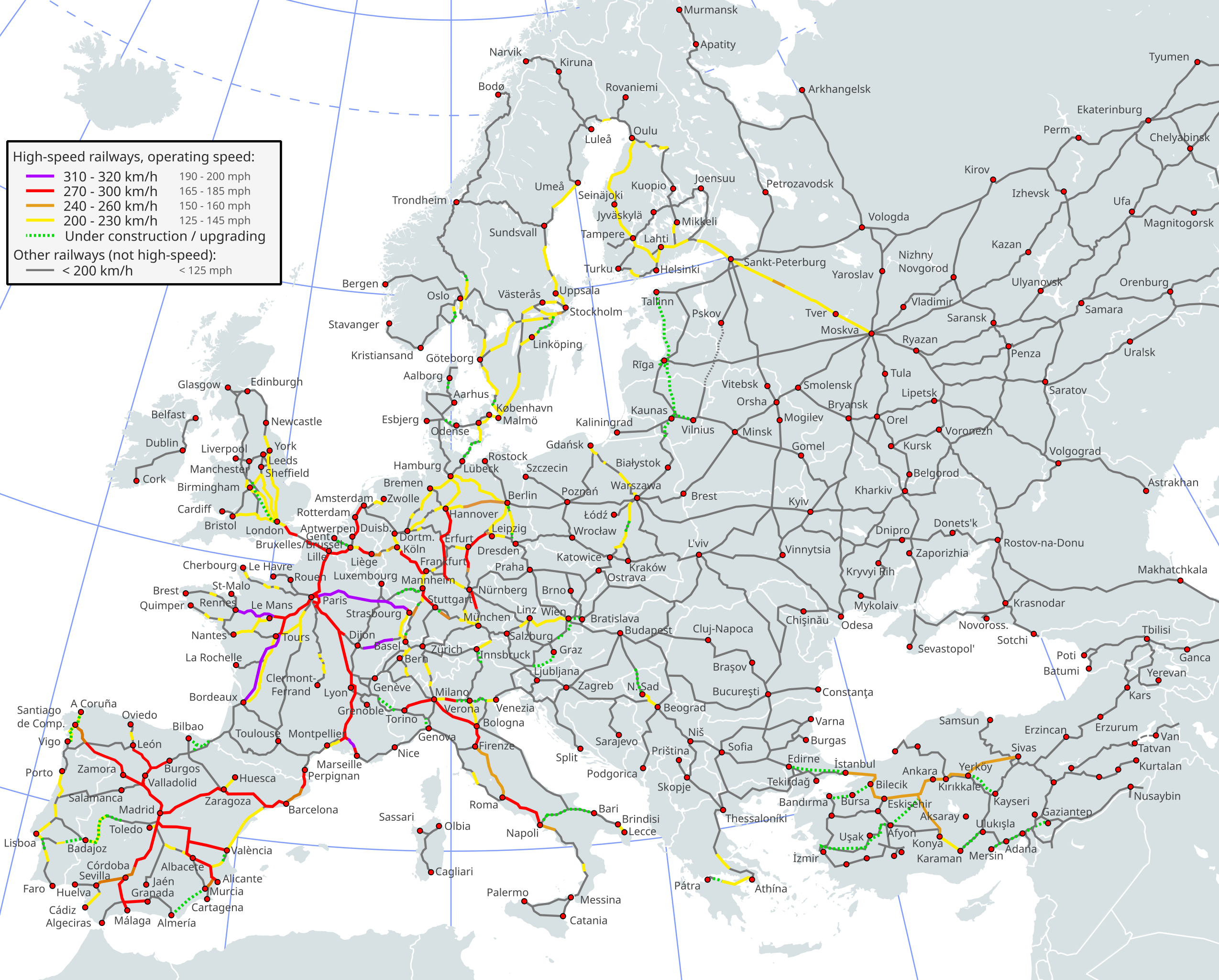
Map of high-speed rail lines in Europe
Dettagli[modifica]

|
Questo file può essere aggiornato per contenere nuove informazioni. Se si desidera utilizzare una versione specifica del file senza i nuovi aggiornamenti, è necessario caricare la versione richiesta in un file separato. |
| Descrizione |
English (en): High-speed railway network in Europe1
310-320km/h (192-198mph) 270-300km/h (167-186mph) 240-260km/h (149-162mph) 200-230km/h (124-142mph) Under construction/Upgrading (dashed lines) Less than 200km/h (124mph) (if dashed line: important international line where there is however currently no passenger traffic)
1 The map depicts the actual operational high-speed instead of the designed one which may be higher.
Deutsch (de): Europäisches Hochgeschwindigkeitsbahnnetz1
310-320 km/h 270-300 km/h 240-260 km/h 200-230 km/h Im Bau/Ausbau (Strichlinien) Weniger als 200 km/h
1 Die Karte zeigt die Betriebshöchstgeschwindigkeit anstatt der für die Linie ausgelegten Höchstgeschwindigkeit, welche höher sein kann.
español (es): Red de ferrocarriles de alta velocidad europea1
310-320 km/h 270-300 km/h 240-260 km/h 200-230 km/h En construcción (líneas rayadas) Menos de 200 km/h
1 El mapa sólo incluye la máxima velocidad comercial de las vías.
suomi (fi): Euroopan suurnopeusrataverkosto1
310-320 km/h 270-300 km/h 240-260 km/h 200-230 km/h Rakenteilla (katkoviivalliset) Alle 200 km/h
1 Kartassa on esitetty toteutuvien operointinopeuksien sijasta teoreettiset ratojen huippunopeudet, jotka saattavat olla todellisia liikennöintinopeuksia korkeampia.
français (fr): Réseau ferré européen à grande vitesse1
310-320 km/h 270-300 km/h 240-260 km/h 200-230 km/h En construction (pointillés) Moins de 200 km/h (si pointillés: ligne internationale d'importance mais actuellement sans trafic voyageurs)
1 Seules les vitesses pratiquées sur les lignes sont prises en compte, pas les vitesses supportées ou théoriques.
Türkçe (tr): Avrupa'da yüksek hızlı demiryolu ağı1
310-320km/s 270-300km/s 240-260km/s 200-230km/s İnşa halinde (çizgili yerler) 200km/s'den az
1 Harita teorik hız yerine fiili işletme hızını yansıtmaktadır. Teorik hız fiili hızdan daha yüksek olabilir.
polski (pl): Mapa linii wysokich prędkości w Europie1
310-320km/h 270-300km/h 240-260km/h 200-230km/h W budowie/modernizacji Mniej niż 200km/h (ważne linie międzynarodowe z czasowo zawieszonym ruchem zaznaczono linią przerywaną)
1 Mapa przedstawia rzeczywistą maksymalną prędkość eksploatacyjną zamiast prędkości projektowanej, która może być wyższa.
Ελληνικά (el): Το σιδηροδρομικό δίκτυο υπερταχείας στην Ευρώπη
310-320 km/h 270-300 km/h 240-260 km/h 200-230 km/h υπό κατασκευή (διακεκομμένη γραμμή) κάτω από 200 km/h
italiano (it): Rete ferroviaria ad alta velocità europea1
310-320 km/h 270-300 km/h 240-260 km/h 200-230 km/h In construzione (linee tratteggiate) Meno di 200 km/h
1 La mappa considera la velocità operativa massima, non la velocità massima nominale.
Nederlands (nl): Het Europese netwerk van hogesnelheidslijnen1
310-320 km/u 270-300 km/u 240-260 km/u 200-230 km/u In aanbouw (stippellijnen) Minder dan 200 km/u
1 De kaart geeft de feitelijke operationele snelheid aan in plaats van de ontworpen snelheid, die soms hoger ligt.
čeština (cs): Vysokorychlostní železniční síť v Evropě1
310-320km/h 270-300km/h 240-260km/h 200-230km/h Ve výstavbě (přerušovaná čára) Méně než 200km/h
1 Mapa zobrazuje aktuální provozní rychlost místo projektované, která může být vyšší.
slovenčina (sk): Vysokorychlostná železničná sieť v Európe1
310-320km/h 270-300km/h 240-260km/h 200-230km/h Vo výstavbe (prerušovaná čiara) Menej ako 200km/h (prerušovaná čiara: dôležitá medzinárodná trať v súčasnosti bez osobnej dopravy)
1 Mapa zobrazuje aktuálnu prevádzkovú rýchlosť namiesto projektovanej, ktorá môže byť vyššia
русский (ru): Высокоскоростная железнодорожная сеть в Европе1
310—320 км/ч (192—198 миль в час) 270—300 км/ч (167—186 миль в час) 240—260 км/ч (149—162 миль в час) 200—230 км/ч (124—142 миль в час) Строится / Модернизируется (пунктирные линии) Менее 200 км / ч (124 миль в час) (пунктирная линия: важная международная линия, где в настоящее время нет пассажирских перевозок)
1 На карте отражена фактическая рабочая скорость, а не запланированная, которая может быть выше.
日本語 (ja): 2017年のヨーロッパの高速鉄道ネットワーク1
310-320km/h (192-198mph) 270-300km/h (167-186mph) 240-260km/h (149-162mph) 200-230km/h (124-142mph) 建設中/改良工事中 (破線) 200km/h未満 (124mph) (破線の場合: 旅客営業を行わない主要国際路線)
1 この地図は実際に運行されている高速鉄道を元に描かれている。
|
| Data | 2014-12-25, last revision 2023-04 |
| Fonte |
Questo file deriva da: High Speed Railroad Map of Europe 2015.svg
|
| Autore |
Original PNG : User:Bernese media, User:BIL 2011 SVG version: User:Akwa and others (see the history & the source file) |
| Altre versioni |
|
| SVG sviluppo | Questa grafica vettoriale è stata creata con Inkscape…importante PLEASE DO NOT REMOVE THE INKSCAPE LAYERS. |


Licenza[modifica]
Questo file è disponibile in base alla licenza Creative Commons Attribuzione-Condividi allo stesso modo 3.0 Unported
- Tu sei libero:
- di condividere – di copiare, distribuire e trasmettere quest'opera
- di modificare – di adattare l'opera
- Alle seguenti condizioni:
- attribuzione – Devi fornire i crediti appropriati, un collegamento alla licenza e indicare se sono state apportate modifiche. Puoi farlo in qualsiasi modo ragionevole, ma non in alcun modo che suggerisca che il licenziante approvi te o il tuo uso.
- condividi allo stesso modo – Se remixi, trasformi o sviluppi il materiale, devi distribuire i tuoi contributi in base alla stessa licenza o compatibile all'originale.
Cronologia del file
Fare clic su un gruppo data/ora per vedere il file come si presentava nel momento indicato.
| Data/Ora | Miniatura | Dimensioni | Utente | Commento | |
|---|---|---|---|---|---|
| attuale | 11:02, 2 feb 2024 | | 1 038 × 834 (1,68 MB) | TheMarcus13 (discussione | contributi) | Spain: Variante de Pajares in Operation, Kopenhagen-Ringsted in Operation (at the moment only IC/EC Kopenhagen-Hamburg can run at up to 200km/h there), passenger service between Lithuania and Latvia resumed, Classic low speed lines with long distnace service from Miranda di Ebro to Bilbao and Irún exist, Crimea bridge |
| 16:17, 18 set 2023 |  | 1 038 × 834 (1,6 MB) | Carfois (discussione | contributi) | Spain: removed the grey line Évora-Elvas (there is no such existing line!) | Added Badajoz city point | Badajoz–Plasencia is curently operated at 200km/h and is being upgraded (electrification) | |
| 16:56, 18 lug 2023 |  | 1 038 × 834 (1,68 MB) | TheMarcus13 (discussione | contributi) | Corrected wrong speed limits (design speed instead of operating speed) of my previous upload | |
| 16:47, 18 lug 2023 |  | 1 038 × 834 (1,68 MB) | TheMarcus13 (discussione | contributi) | Updated high-speed lines in Sweden (Botniabanan, nya haparandabanan), Norway (Follobanen Oslo-Ski) and Portugal/Spain (Lisbon-Evora-Badajoz-Madrid) | |
| 19:29, 18 giu 2023 |  | 1 038 × 834 (1,67 MB) | Jklamo (discussione | contributi) | Greece corrected (only some sections are 200 km/h), Catania - Palermo added (ongoing modernisation) | |
| 12:05, 16 mag 2023 |  | 1 038 × 834 (1,67 MB) | Emturan (discussione | contributi) | For the Ankara-Afyon-Usak-İzmir high-speed railway, the route at the Afyon-İzmir section has been corrected. The Turgutlu-Manisa-İzmir section is an upgrade. For the rest, a new two-lane line is under construction. Usak City has added. Aksaray City has added. (A new high-speed line between Ulukışla-Aksaray has been planned and started. An upgrade between Ulukışla-Yenice will connect Mersin-Adana-Gaziantep high-speed line to the rest of the high-speed network.) | |
| 13:50, 28 apr 2023 |  | 1 038 × 834 (1,59 MB) | Carfois (discussione | contributi) | Germany: the 60km-long Wendlingen–Ulm high-speed railway (250 km/h) entered in service in December 2022 | |
| 22:55, 27 apr 2023 |  | 1 038 × 834 (1,59 MB) | Carfois (discussione | contributi) | Spain: corrected some speeds (including on Madrid-Zaragoza, as there is no more service operating at 310 km/h in Spain since 2016) | |
| 20:34, 26 apr 2023 |  | 1 038 × 834 (1,67 MB) | Emturan (discussione | contributi) | Ankara-Kirikkale-YerKöy-Yozgat-Sivas High Speed Line opened to revenue service. | |
| 13:45, 26 apr 2023 |  | 1 038 × 834 (1,59 MB) | Carfois (discussione | contributi) | Sweden & Finland: removed dots on the sections Luleå-Haparanda and Kemi–Tornio since there is now passenger traffic on them. | Spain: corrected speed on Sevilla-Cadix (one part is at 140/160 km/h) / added the Algeciras city point |
Impossibile sovrascrivere questo file.
Utilizzo del file
Più di 100 pagine usano questo file. Di seguito sono elencate solo le prime 100 pagine che usano questo file. È disponibile un elenco completo.
- High speed trains
- Railway lines
- User:Chumwa/OgreBot/Potential transport maps/2016 August 1-10
- User:Chumwa/OgreBot/Potential transport maps/2016 August 11-20
- User:Chumwa/OgreBot/Potential transport maps/2016 July 1-10
- User:Chumwa/OgreBot/Potential transport maps/2017 December 1-10
- User:Chumwa/OgreBot/Potential transport maps/2017 December 11-20
- User:Chumwa/OgreBot/Potential transport maps/2017 July 1-10
- User:Chumwa/OgreBot/Potential transport maps/2017 July 11-20
- User:Chumwa/OgreBot/Potential transport maps/2017 July 21-31
- User:Chumwa/OgreBot/Potential transport maps/2017 June 1-10
- User:Chumwa/OgreBot/Potential transport maps/2017 June 11-20
- User:Chumwa/OgreBot/Potential transport maps/2017 March 1-10
- User:Chumwa/OgreBot/Potential transport maps/2017 March 21-31
- User:Chumwa/OgreBot/Potential transport maps/2017 May 11-20
- User:Chumwa/OgreBot/Potential transport maps/2017 May 21-31
- User:Chumwa/OgreBot/Potential transport maps/2018 December 1-10
- User:Chumwa/OgreBot/Potential transport maps/2018 January 21-31
- User:Chumwa/OgreBot/Potential transport maps/2018 September 21-30
- User:Chumwa/OgreBot/Public transport information/2014 December 21-31
- User:Chumwa/OgreBot/Public transport information/2016 August 1-10
- User:Chumwa/OgreBot/Public transport information/2016 August 11-20
- User:Chumwa/OgreBot/Public transport information/2016 July 1-10
- User:Chumwa/OgreBot/Public transport information/2017 December 1-10
- User:Chumwa/OgreBot/Public transport information/2017 December 11-20
- User:Chumwa/OgreBot/Public transport information/2017 July 1-10
- User:Chumwa/OgreBot/Public transport information/2017 July 11-20
- User:Chumwa/OgreBot/Public transport information/2017 July 21-31
- User:Chumwa/OgreBot/Public transport information/2017 June 1-10
- User:Chumwa/OgreBot/Public transport information/2017 June 11-20
- User:Chumwa/OgreBot/Public transport information/2017 March 1-10
- User:Chumwa/OgreBot/Public transport information/2017 March 21-31
- User:Chumwa/OgreBot/Public transport information/2017 May 11-20
- User:Chumwa/OgreBot/Public transport information/2017 May 21-31
- User:Chumwa/OgreBot/Public transport information/2018 December 1-10
- User:Chumwa/OgreBot/Public transport information/2018 January 21-31
- User:Chumwa/OgreBot/Public transport information/2018 September 21-30
- User:Chumwa/OgreBot/Transport Maps/2014 December 21-31
- User:Chumwa/OgreBot/Transport Maps/2016 August 1-10
- User:Chumwa/OgreBot/Transport Maps/2016 August 11-20
- User:Chumwa/OgreBot/Transport Maps/2016 July 1-10
- User:Chumwa/OgreBot/Transport Maps/2017 December 1-10
- User:Chumwa/OgreBot/Transport Maps/2017 December 11-20
- User:Chumwa/OgreBot/Transport Maps/2017 July 1-10
- User:Chumwa/OgreBot/Transport Maps/2017 July 11-20
- User:Chumwa/OgreBot/Transport Maps/2017 July 21-31
- User:Chumwa/OgreBot/Transport Maps/2017 June 1-10
- User:Chumwa/OgreBot/Transport Maps/2017 June 11-20
- User:Chumwa/OgreBot/Transport Maps/2017 March 1-10
- User:Chumwa/OgreBot/Transport Maps/2017 March 21-31
- User:Chumwa/OgreBot/Transport Maps/2017 May 11-20
- User:Chumwa/OgreBot/Transport Maps/2017 May 21-31
- User:Chumwa/OgreBot/Transport Maps/2018 December 1-10
- User:Chumwa/OgreBot/Transport Maps/2018 January 21-31
- User:Chumwa/OgreBot/Transport Maps/2018 September 21-30
- User:Chumwa/OgreBot/Travel and communication maps/2016 August 1-10
- User:Chumwa/OgreBot/Travel and communication maps/2016 August 11-20
- User:Chumwa/OgreBot/Travel and communication maps/2016 July 1-10
- User:Chumwa/OgreBot/Travel and communication maps/2017 December 1-10
- User:Chumwa/OgreBot/Travel and communication maps/2017 December 11-20
- User:Chumwa/OgreBot/Travel and communication maps/2017 July 1-10
- User:Chumwa/OgreBot/Travel and communication maps/2017 July 11-20
- User:Chumwa/OgreBot/Travel and communication maps/2017 July 21-31
- User:Chumwa/OgreBot/Travel and communication maps/2017 June 1-10
- User:Chumwa/OgreBot/Travel and communication maps/2017 June 11-20
- User:Chumwa/OgreBot/Travel and communication maps/2017 March 1-10
- User:Chumwa/OgreBot/Travel and communication maps/2017 March 21-31
- User:Chumwa/OgreBot/Travel and communication maps/2017 May 11-20
- User:Chumwa/OgreBot/Travel and communication maps/2017 May 21-31
- User:Chumwa/OgreBot/Travel and communication maps/2018 December 1-10
- User:Chumwa/OgreBot/Travel and communication maps/2018 January 21-31
- User:Chumwa/OgreBot/Travel and communication maps/2018 September 21-30
- User:Frettiebot/Galleries/Jklamo/2016/8
- User:Hoff1980/Rail transport in France/2014 December 21-31
- User:Liesel/Rail transport/2014 December 21-31
- User:Mattbuck/Railways/2014 December 21-31
- User:Mattbuck/Railways/2016 August 1-10
- User:Mattbuck/Railways/2016 August 11-20
- User:Mattbuck/Railways/2016 July 1-10
- User:Mattbuck/Railways/2017 December 1-10
- User:Mattbuck/Railways/2017 December 11-20
- User:Mattbuck/Railways/2017 July 1-10
- User:Mattbuck/Railways/2017 July 11-20
- User:Mattbuck/Railways/2017 July 21-31
- User:Mattbuck/Railways/2017 June 1-10
- User:Mattbuck/Railways/2017 June 11-20
- User:Mattbuck/Railways/2017 March 1-10
- User:Mattbuck/Railways/2017 March 21-31
- User:Mattbuck/Railways/2017 May 11-20
- User:Mattbuck/Railways/2017 May 21-31
- User:Mattbuck/Railways/2018 December
- User:Mattbuck/Railways/2018 January 21-31
- User:Mattbuck/Railways/2018 September
- User:Nordlicht8/Rail Germany/2014 December 21-31
- User:Nordlicht8/Rail Germany/2016 August 1-10
- User:Nordlicht8/Rail Germany/2016 August 11-20
- User:Nordlicht8/Rail Germany/2016 July 1-10
- Commons:Structured data/Get involved/Feedback requests/Properties for Commons
- File:High Speed Railroad Map of Europe 2015.svg
- File:High Speed Railroad Map of Europe 2016.svg
Visualizza altri collegamenti a questo file.
Utilizzo globale del file
Anche i seguenti wiki usano questo file:
- Usato nelle seguenti pagine di ar.wikipedia.org:
- Usato nelle seguenti pagine di ast.wikipedia.org:
- Usato nelle seguenti pagine di ca.wikipedia.org:
- Usato nelle seguenti pagine di cs.wikipedia.org:
- Usato nelle seguenti pagine di da.wikipedia.org:
- Usato nelle seguenti pagine di de.wikipedia.org:
- Usato nelle seguenti pagine di de.wikivoyage.org:
- Usato nelle seguenti pagine di el.wikipedia.org:
- Usato nelle seguenti pagine di en.wikipedia.org:
- Usato nelle seguenti pagine di en.wikivoyage.org:
- Usato nelle seguenti pagine di eo.wikipedia.org:
- Usato nelle seguenti pagine di es.wikipedia.org:
- Usato nelle seguenti pagine di et.wikipedia.org:
- Usato nelle seguenti pagine di eu.wikipedia.org:
- Usato nelle seguenti pagine di fi.wikipedia.org:
- Usato nelle seguenti pagine di fr.wikipedia.org:
- Ligne à grande vitesse
- Route européenne
- Réseau transeuropéen de transport
- Autoroute de la mer
- Grande vitesse ferroviaire
- Liste des lignes à grande vitesse
- Liste des lignes à grande vitesse en France
- Allegro (train)
- Agence exécutive européenne pour le climat, les infrastructures et l’environnement
- Corridor Scandinavie-Méditerranée
- Corridor Orient/Méditerranée orientale
- Corridor Rhin-Danube
- Corridor Mer du Nord-Baltique
- Corridor Mer du Nord-Méditerranée
- Modèle:Palette Réseau transeuropéen de transport (RTE-T)
- Réseaux transeuropéens
- Corridor méditerranéen
Visualizza l'utilizzo globale di questo file.