File:India in 350 CE Joppen.jpg
Jump to navigation
Jump to search

Size of this preview: 410 × 599 pixels. Other resolutions: 164 × 240 pixels | 328 × 480 pixels | 525 × 768 pixels | 700 × 1,024 pixels | 1,401 × 2,048 pixels | 2,630 × 3,845 pixels.
Original file (2,630 × 3,845 pixels, file size: 2.64 MB, MIME type: image/jpeg)
Captions
Captions
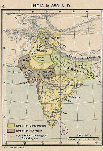
{{en|1=A map of the geographical extent of the [[:en:Gupta Empire|Gupta emperor]] [[:en:Samudragupta|Samudragupta]] circa 350 CE}}
Summary[edit]
| Description | |
| Date | |
| Source | From a personal copy of A Historical Atlas of India by Charles Joppen SJ, London: Longman Greens, 1907 Fowler&fowler (talk) 20:52, 20 August 2019 (UTC) |
| Author | Justus Perthes, Gotha, 1907 |
Licensing[edit]
|
This work is in the public domain in its country of origin and other countries and areas where the copyright term is the author's life plus 70 years or fewer. This work is in the public domain in the United States because it was published (or registered with the U.S. Copyright Office) before January 1, 1929. | |
| This file has been identified as being free of known restrictions under copyright law, including all related and neighboring rights. | |
File history
Click on a date/time to view the file as it appeared at that time.
| Date/Time | Thumbnail | Dimensions | User | Comment | |
|---|---|---|---|---|---|
| current | 20:52, 20 August 2019 | | 2,630 × 3,845 (2.64 MB) | Fowler&fowler (talk | contribs) | User created page with UploadWizard |
You cannot overwrite this file.
File usage on Commons
The following page uses this file:
- File:INDIA in 350 B. C.jpg (file redirect)
File usage on other wikis
The following other wikis use this file:
- Usage on ar.wikipedia.org
- Usage on ckb.wikipedia.org
- Usage on en.wikipedia.org
- Usage on hy.wikipedia.org
- Usage on ro.wikipedia.org