File:Indus flooding 2010 en.svg
Jump to navigation
Jump to search

Size of this PNG preview of this SVG file: 707 × 600 pixels. Other resolutions: 283 × 240 pixels | 566 × 480 pixels | 906 × 768 pixels | 1,207 × 1,024 pixels | 2,415 × 2,048 pixels | 856 × 726 pixels.
Original file (SVG file, nominally 856 × 726 pixels, file size: 702 KB)
Captions
Captions
Add a one-line explanation of what this file represents
Summary[edit]
| Description |
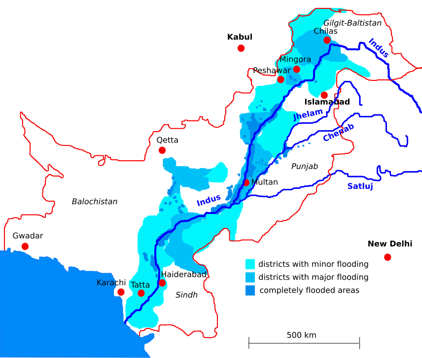
English: based on: http://www.spiegel.de/panorama/0,1518,711885,00.html, Google Earth and Times Atlas,
flooding zones as of 2010-8-26 |
| Date | |
| Source | Own work |
| Author | Kmhkmh |
Licensing[edit]
I, the copyright holder of this work, hereby publish it under the following license:
This file is licensed under the Creative Commons Attribution 3.0 Unported license.
- You are free:
- to share – to copy, distribute and transmit the work
- to remix – to adapt the work
- Under the following conditions:
- attribution – You must give appropriate credit, provide a link to the license, and indicate if changes were made. You may do so in any reasonable manner, but not in any way that suggests the licensor endorses you or your use.
File history
Click on a date/time to view the file as it appeared at that time.
| Date/Time | Thumbnail | Dimensions | User | Comment | |
|---|---|---|---|---|---|
| current | 22:48, 28 August 2010 | | 856 × 726 (702 KB) | Kmhkmh (talk | contribs) | size reduction, region added |
| 22:26, 28 August 2010 | No thumbnail | 856 × 726 (839 KB) | Kmhkmh (talk | contribs) | {{Information |Description={{en|1=based on: http://www.spiegel.de/panorama/0,1518,711885,00.html, Google Earth and Times Atlas flooding zones as of 2010-8-26}} |Source={{own}} |Author=Kmhkmh |Date=2010-8-28 |Permission= |other_versions= }} |
You cannot overwrite this file.
File usage on Commons
The following 2 pages use this file:
File usage on other wikis
The following other wikis use this file:
- Usage on ast.wikipedia.org
- Usage on ca.wikipedia.org
- Usage on de.wikipedia.org
- Usage on en.wikipedia.org
- Usage on es.wikipedia.org
- Usage on fa.wikipedia.org
- Usage on fr.wikipedia.org
- Usage on gl.wikipedia.org
- Usage on he.wikipedia.org
- Usage on hu.wikipedia.org
- Usage on id.wikipedia.org
- Usage on it.wikipedia.org
- Usage on ja.wikipedia.org
- Usage on kn.wikipedia.org
- Usage on nds.wikipedia.org
- Usage on nl.wikipedia.org
- Usage on no.wikipedia.org
- Usage on or.wikipedia.org
- Usage on pt.wikipedia.org
- Usage on ru.wikipedia.org
- Usage on sl.wikipedia.org
- Usage on th.wikipedia.org
- Usage on uk.wikipedia.org
- Usage on uz.wikipedia.org
- Usage on vi.wikipedia.org
- Usage on www.wikidata.org
- Usage on zh.wikipedia.org