File:Island of Ireland location map Clare.svg
Vai alla navigazione
Vai alla ricerca

Dimensioni di questa anteprima PNG per questo file SVG: 481 × 599 pixel. Altre risoluzioni: 192 × 240 pixel | 385 × 480 pixel | 616 × 768 pixel | 822 × 1 024 pixel | 1 643 × 2 048 pixel | 1 450 × 1 807 pixel.
File originale (file in formato SVG, dimensioni nominali 1 450 × 1 807 pixel, dimensione del file: 642 KB)
Didascalie
Didascalie
Aggiungi una brevissima spiegazione di ciò che questo file rappresenta
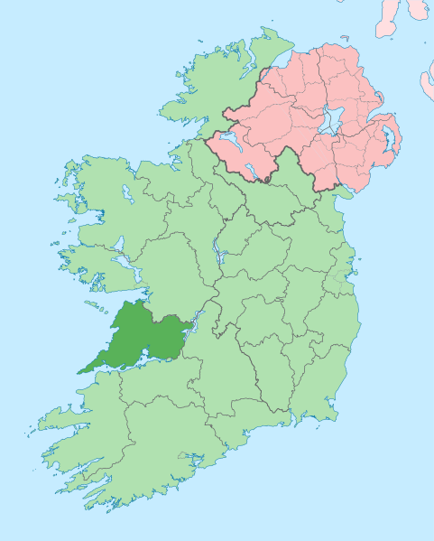
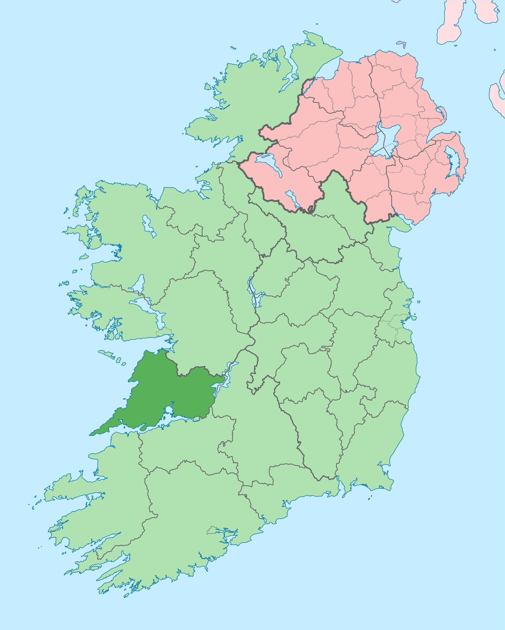
Clare on a map
| Descrizione |
English: The island of Ireland, showing international border between Ireland and Northern Ireland, traditional provinces, traditional counties, and local authority areas in Ireland and Northern Ireland. |
| Data | (UTC) |
| Fonte | |
| Autore |
|
| Questa è una immagine ritoccata, il che significa che è stata modificata digitalmente dalla sua versione originale. Modifiche: Coloured in regions with county of article highlighted. La versione originale può essere vista qui: Island of Ireland location map.svg. Le modifiche sono di Mabuska.
|
Io, detentore del copyright su quest'opera, dichiaro di pubblicarla con la seguente licenza:
Questo file è disponibile in base alla licenza Creative Commons Attribuzione-Condividi allo stesso modo 3.0 Unported
- Tu sei libero:
- di condividere – di copiare, distribuire e trasmettere quest'opera
- di modificare – di adattare l'opera
- Alle seguenti condizioni:
- attribuzione – Devi fornire i crediti appropriati, un collegamento alla licenza e indicare se sono state apportate modifiche. Puoi farlo in qualsiasi modo ragionevole, ma non in alcun modo che suggerisca che il licenziante approvi te o il tuo uso.
- condividi allo stesso modo – Se remixi, trasformi o sviluppi il materiale, devi distribuire i tuoi contributi in base alla stessa licenza o compatibile all'originale.
Registro originale del caricamento
[modifica]
This image is a derivative work of the following images:
- File:Island_of_Ireland_location_map.svg licensed with Cc-by-sa-3.0
- 2010-03-06T20:43:33Z Rannpháirtí anaithnid 1450x1807 (679207 Bytes) Fix incorrectly coloured isands.
- 2010-03-03T22:19:29Z Rannpháirtí anaithnid 1450x1807 (679744 Bytes) {{Information |Description={{de|Positionskarte von [[:de:Irland|Irland]]}} Quadratische Plattkarte, N-S-Streckung 170 %. Geographische Begrenzung der Karte: * N: 55.6° N * S: 51.2° N * W: 11.0° W * O: 5.0° W {{en|Location
Uploaded with derivativeFX
Cronologia del file
Fare clic su un gruppo data/ora per vedere il file come si presentava nel momento indicato.
| Data/Ora | Miniatura | Dimensioni | Utente | Commento | |
|---|---|---|---|---|---|
| attuale | 14:05, 28 giu 2020 | | 1 450 × 1 807 (642 KB) | Chipmunkdavis (discussione | contributi) | Colouring in Aughinish |
| 15:54, 26 giu 2020 |  | 1 450 × 1 807 (642 KB) | Chipmunkdavis (discussione | contributi) | Rmv stray number in code | |
| 15:26, 26 giu 2020 |  | 1 450 × 1 807 (642 KB) | Chipmunkdavis (discussione | contributi) | Merging Tipperary and Waterford shapes | |
| 12:55, 26 giu 2020 |  | 1 450 × 1 807 (643 KB) | Chipmunkdavis (discussione | contributi) | Removing Limerick City | |
| 16:21, 25 giu 2020 |  | 1 450 × 1 807 (643 KB) | Chipmunkdavis (discussione | contributi) | Per the Local Government Reform Act 2014, removing the Tipperary border and the Waterford City border. | |
| 16:10, 25 giu 2020 |  | 1 450 × 1 807 (646 KB) | Chipmunkdavis (discussione | contributi) | Removing lots of stray objects. Fixing location of Clare and one island slightly. | |
| 15:45, 25 giu 2020 |  | 1 450 × 1 807 (695 KB) | Chipmunkdavis (discussione | contributi) | Colour islands in, place all islands and borders in groups, remove some blank and redundant shapes | |
| 00:41, 19 lug 2010 |  | 1 450 × 1 807 (815 KB) | Mabuska (discussione | contributi) | {{Information |Description={{en|The island of Ireland, showing international border between Northern Ireland and Republic of Ireland, traditional provinces, traditional counties, and local authority areas in the Republic of Ireland and Northern Ireland.}} |
Impossibile sovrascrivere questo file.
Utilizzo del file
Le seguenti 11 pagine usano questo file:
- Commons:Files used on the AARoads Wiki/79
- Category:Archaeological sites in County Clare
- Category:Births in County Clare
- Category:Castles in County Clare
- Category:County Clare
- Category:Disused railway stations in County Clare
- Category:Maps of County Clare
- Category:People of County Clare
- Category:Railway stations in County Clare
- Category:Rivers of County Clare
- Category:Roads in County Clare
Utilizzo globale del file
Anche i seguenti wiki usano questo file:
- Usato nelle seguenti pagine di ar.wikipedia.org:
- Usato nelle seguenti pagine di ast.wikipedia.org:
- Usato nelle seguenti pagine di bg.wikipedia.org:
- Usato nelle seguenti pagine di ca.wikipedia.org:
- Usato nelle seguenti pagine di ceb.wikipedia.org:
- Usato nelle seguenti pagine di cs.wikipedia.org:
- Usato nelle seguenti pagine di en.wikipedia.org:
- County Clare
- Inagh
- Ennis
- List of Ireland-related topics
- Shannon, County Clare
- Lissycasey
- Shannon Free Zone
- Lisdoonvarna
- Cratloe
- Doolin
- Kilfenora
- Ballyvaughan
- Carran
- Kilkee
- Kilrush
- Clarecastle
- Ennistymon
- Killaloe, County Clare
- Lahinch
- Liscannor
- Mountshannon
- Newmarket-on-Fergus
- O'Brien's Bridge
- Spanish Point, County Clare
- Aughinish, County Clare
Visualizza l'utilizzo globale di questo file.