File:Ivan 2004-09-11 1610Z.jpg
Vai alla navigazione
Vai alla ricerca

Dimensioni di questa anteprima: 461 × 599 pixel. Altre risoluzioni: 184 × 240 pixel | 369 × 480 pixel | 591 × 768 pixel | 788 × 1 024 pixel | 1 575 × 2 048 pixel | 6 000 × 7 800 pixel.
File originale (6 000 × 7 800 pixel, dimensione del file: 6,58 MB, tipo MIME: image/jpeg)
Didascalie
Didascalie
Aggiungi una brevissima spiegazione di ciò che questo file rappresenta
Dettagli[modifica]
| Descrizione |
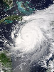
The MODIS instrument aboard NASA's Terra satellite captured this true-color image of Hurricane Ivan on Septebmer 11, 2004 at 16:10 UTC (12:10 PM EDT). At the time this image was taken Ivan was located approximately 50 km (30 miles) southwest of the western tip of Jamaica and was moving towards the west-northwest at 13 km/hr (8 mph). Ivan had maximum sustained winds of 230 km/hr (145 mph) with higher gusts. The MODIS Rapid Response System provides this image at additional resolutions and formats. |
|||||
| Data | ||||||
| Fonte | http://earthobservatory.nasa.gov/NaturalHazards/natural_hazards_v2.php3?img_id=12428 | |||||
| Autore | NASA image courtesy Jacques Descloitres, MODIS Land Rapid Response Team at NASA GSFC. | |||||
| Licenza (Riusare questo file) |
|

Cronologia del file
Fare clic su un gruppo data/ora per vedere il file come si presentava nel momento indicato.
| Data/Ora | Miniatura | Dimensioni | Utente | Commento | |
|---|---|---|---|---|---|
| attuale | 22:01, 8 nov 2006 | | 6 000 × 7 800 (6,58 MB) | Good kitty (discussione | contributi) | == Summary == {{Information |Description=The MODIS instrument aboard NASA's Terra satellite captured this true-color image of Hurricane Ivan on Septebmer 11, 2004 at 16:10 UTC (12:10 PM EDT). At the time this image was taken Ivan was located approximately |
Impossibile sovrascrivere questo file.
Utilizzo del file
La seguente pagina usa questo file:
- File:Hurricane Ivan 11 sept 2004 1610Z.jpg (reindirizzamento file)
Utilizzo globale del file
Anche i seguenti wiki usano questo file:
- Usato nelle seguenti pagine di ca.wikipedia.org:
- Usato nelle seguenti pagine di en.wikipedia.org:
- Usato nelle seguenti pagine di it.wikipedia.org:
- Usato nelle seguenti pagine di jam.wikipedia.org:
- Usato nelle seguenti pagine di pl.wikipedia.org:
- Usato nelle seguenti pagine di ru.wikipedia.org:
- Usato nelle seguenti pagine di th.wikipedia.org:
- Usato nelle seguenti pagine di uk.wikipedia.org:
- Usato nelle seguenti pagine di zh.wikipedia.org: