File:Karnataka districts map.svg
Jump to navigation
Jump to search

Size of this PNG preview of this SVG file: 414 × 600 pixels. Other resolutions: 166 × 240 pixels | 331 × 480 pixels | 530 × 768 pixels | 707 × 1,024 pixels | 1,414 × 2,048 pixels | 1,634 × 2,367 pixels.
Original file (SVG file, nominally 1,634 × 2,367 pixels, file size: 323 KB)
Captions
Captions
Add a one-line explanation of what this file represents
Summary[edit]
| Description |
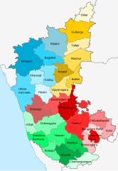
English: Map of Karnataka districts organized by division. Shades of red - Bengaluru division, shades of green - Mysore division, shades of blue - Belgaum division, shades of yellow - Gulbarga division |
| Date | |
| Source | Derivative of File:India Karnataka location map.svg |
| Author | Own work based on User:Nayvik |
Licensing[edit]
This file is licensed under the Creative Commons Attribution-Share Alike 3.0 Unported license.
- You are free:
- to share – to copy, distribute and transmit the work
- to remix – to adapt the work
- Under the following conditions:
- attribution – You must give appropriate credit, provide a link to the license, and indicate if changes were made. You may do so in any reasonable manner, but not in any way that suggests the licensor endorses you or your use.
- share alike – If you remix, transform, or build upon the material, you must distribute your contributions under the same or compatible license as the original.
File history
Click on a date/time to view the file as it appeared at that time.
| Date/Time | Thumbnail | Dimensions | User | Comment | |
|---|---|---|---|---|---|
| current | 04:27, 28 January 2021 | | 1,634 × 2,367 (323 KB) | C1MM (talk | contribs) | Fixed misspelling |
| 04:24, 28 January 2021 |  | 1,634 × 2,367 (323 KB) | C1MM (talk | contribs) | Uploaded a work by Own work based on User:Nayvik from Derivative of File:India Karnataka location map.svg with UploadWizard |
You cannot overwrite this file.
File usage on Commons
There are no pages that use this file.
File usage on other wikis
The following other wikis use this file:
- Usage on fr.wikipedia.org
- Usage on ta.wikipedia.org