File:Kazembe Kingdom 433x455.JPG
Jump to navigation
Jump to search
No higher resolution available.
Kazembe_Kingdom_433x455.JPG (433 × 455 pixels, file size: 50 KB, MIME type: image/jpeg)
Captions
Captions
Add a one-line explanation of what this file represents
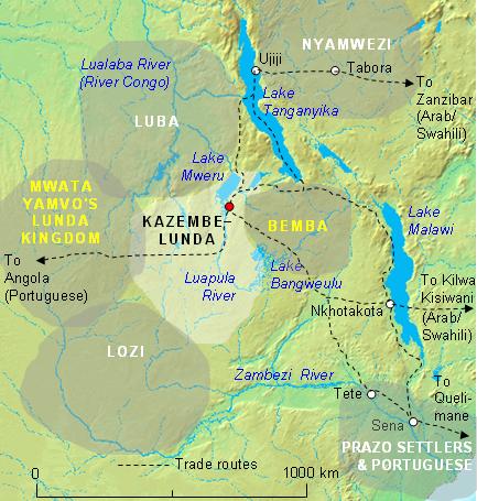
| Description | The Kazembe Kingdom (light area, and capital shown as red dot) in its prime in the first half of the 19th Century, before Msiri took south-east Katanga. Boundaries of territories and principal trade routes shown are approximate. See the article on Msiri for the same area in 1880. |
| Date | |
| Source | MS Word drawing |
| Author | Rex Parry |
I, the copyright holder of this work, hereby publish it under the following licenses:

|
Permission is granted to copy, distribute and/or modify this document under the terms of the GNU Free Documentation License, Version 1.2 or any later version published by the Free Software Foundation; with no Invariant Sections, no Front-Cover Texts, and no Back-Cover Texts. A copy of the license is included in the section entitled GNU Free Documentation License. |
| This file is licensed under the Creative Commons Attribution-Share Alike 3.0 Unported license. | ||
| ||
| This licensing tag was added to this file as part of the GFDL licensing update. |
This file is licensed under the Creative Commons Attribution 2.5 Generic license.
- You are free:
- to share – to copy, distribute and transmit the work
- to remix – to adapt the work
- Under the following conditions:
- attribution – You must give appropriate credit, provide a link to the license, and indicate if changes were made. You may do so in any reasonable manner, but not in any way that suggests the licensor endorses you or your use.
You may select the license of your choice.
File history
Click on a date/time to view the file as it appeared at that time.
| Date/Time | Thumbnail | Dimensions | User | Comment | |
|---|---|---|---|---|---|
| current | 02:51, 14 February 2007 | | 433 × 455 (50 KB) | Rexparry sydney~commonswiki (talk | contribs) | The Kazembe Kingdom (light area, and capital shown as red dot) in its prime in the first half of the 19th Century, before Msiri took south-east Katanga. Boundaries of territories and principal trade routes shown are approximate. |
You cannot overwrite this file.
File usage on Commons
There are no pages that use this file.
File usage on other wikis
The following other wikis use this file:
- Usage on ca.wikipedia.org
- Usage on en.wikipedia.org
- Usage on es.wikipedia.org
- Usage on fr.wikipedia.org
- Usage on he.wikipedia.org
- Usage on id.wikipedia.org
- Usage on it.wikipedia.org
- Usage on lt.wikipedia.org
- Usage on no.wikipedia.org
- Usage on pt.wikibooks.org
- Usage on tum.wikipedia.org
- Usage on uk.wikipedia.org