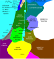
File:Kingdoms of Israel and Judah map 830.svg

പൂർണ്ണ വലിപ്പം (എസ്.വി.ജി. പ്രമാണം, നാമമാത്രമായ 720 × 859 പിക്സലുകൾ, പ്രമാണത്തിന്റെ വലിപ്പം: 96 കെ.ബി.)
തലവാചകം
തലവാചകങ്ങൾ
| വിവരണംKingdoms of Israel and Judah map 830.svg |
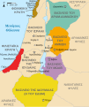
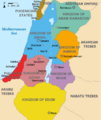
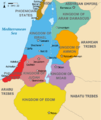
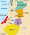
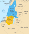
English: Approximate map showing the Kingdoms of Israel (blue) and Judah (orange), ancient Southern Levant borders and ancient cities such as Urmomium and Jerash. The map shows the region in the 9th century BCE. Italiano: Il regno di Giuda e quello di Israele nell'età del ferro (VIII secolo a.C.).
日本語: 紀元前830年代のユダ王国(黄色).
Русский: Царство Иудея 927 по 526 гг. до н. э. Отсюда иудеи были сосланы завоевателями в Вавилонский регион.
Bahasa Indonesia: Peta kerajaan-kerajaan di daerah tersebut pada abad 9 SM.
Simple English: The northern Kingdom of Israel and the Kingdom of Judah to the south.
Srpskohrvatski / српскохрватски: Karta Sjevernog i JUžnog Kraljevstva. Samarija je bila glavni grad Kraljevstva Izrael (plavo). 830-e pne.,.
Latviešu: Izraēlas un Jūdejas karalistes. Jūdejas karaliste (dzeltenā) ap 830. gadu p.m.ē. |
| തീയതി | (UTC) |
| സ്രോതസ്സ് | http://www.jewishvirtuallibrary.org/map-of-israel-and-judah-733-bce |
| സ്രഷ്ടാവ് |
|
| മറ്റു പതിപ്പുകൾ |
|
- താങ്കൾക്കുള്ള സ്വാതന്ത്ര്യങ്ങൾ:
- പങ്ക് വെയ്ക്കൽ – കൃതി പകർത്താനും, വിതരണം ചെയ്യാനും, പ്രസരിപ്പിക്കാനും
- പുനഃമിശ്രണം ചെയ്യൽ – കൃതി അനുയുക്തമാക്കാൻ
- താഴെ പറയുന്ന ഉപാധികൾ പാലിക്കുക:
- കടപ്പാട് – രചയിതാവോ അനുമതിയുള്ളയാളോ വ്യക്തമാക്കിയിട്ടുള്ള വിധത്തിൽ കൃതിയ്ക്കുള്ള കടപ്പാട് താങ്കൾ നൽകിയിരിക്കണം. താങ്കൾക്കിത് ഏത് വിധത്തിൽ വേണമെങ്കിലും ചെയ്യാവുന്നതാണ്, പക്ഷേ അത് അവർ താങ്കളേയോ താങ്കളുടെ ഉപയോഗത്തേയോ അടിച്ചേൽപ്പിച്ചതു പോലെയാവരുത്.
- ഇതു പോലെ പങ്ക് വെയ്ക്കുക – ഈ സൃഷ്ടിയെ പുനഃമിശ്രണം ചെയ്തോ രൂപാന്തരപ്പെടുത്തിയോ അടിസ്ഥാനപ്പെടുത്തിയോ ഉണ്ടാക്കുന്നവ; താങ്കളുടെ സംഭാവനയടക്കമുള്ള സൃഷ്ടി യഥാർത്ഥ സൃഷ്ടിയുടെ അതേ അല്ലെങ്കിൽ അനുരൂപമായ ഉപയോഗാനുമതിയിൽ മാത്രമേ താങ്കൾ വിതരണം ചെയ്യാവൂ.

|
സ്വതന്ത്ര സോഫ്റ്റ്വേർ സമിതി പ്രസിദ്ധീകരിച്ചിട്ടുള്ള ഗ്നു സ്വതന്ത്ര പ്രമാണ അനുവാദപത്രം പതിപ്പ് 1.2 അല്ലെങ്കിൽ പുതിയ പതിപ്പുകൾ പ്രകാരം; മാറ്റമില്ലാത്ത ഭാഗങ്ങളില്ലാതെ, മുൻചട്ടയിലെ എഴുത്തുകൾ ഇല്ലാതെ, പിൻചട്ടയിലെ എഴുത്തുകൾ ഇല്ലാതെ പകർത്താനും, വിതരണം ചെയ്യാനും ഒപ്പം/അല്ലെങ്കിൽ ഈ പ്രമാണത്തിൽ മാറ്റം വരുത്തുവാനും ഉള്ള അവകാശങ്ങൾ നൽകുന്നു. ഗ്നു സ്വതന്ത്ര പ്രമാണ അനുവാദപത്രം എന്ന തലക്കെട്ടിൽ അനുവാദപത്രത്തിന്റെ ഒരു പകർപ്പ് ഉൾപ്പെടുത്തിയിട്ടുണ്ട്.http://www.gnu.org/copyleft/fdl.htmlGFDLGNU Free Documentation Licensetruetrue |
യഥാർത്ഥ അപ്ലോഡ് രേഖ
[തിരുത്തുക]This image is a derivative work of the following images:
- File:Oldtidens_Israel_&_Judea.svg licensed with Cc-by-sa-3.0, GFDL
- 2010-01-30T16:10:36Z FinnWikiNo 726x868 (109641 Bytes) {{Information |Description={{en|1=Map showing the ancient levant borders and ancient cities such as [[Urmomium]] and [[Jerash]]. The map also shows the region in the 9th century BCE. Notice the coastal land of Philistia, from
Uploaded with derivativeFX
പ്രമാണ നാൾവഴി
ഏതെങ്കിലും തീയതി/സമയ കണ്ണിയിൽ ഞെക്കിയാൽ പ്രസ്തുതസമയത്ത് ഈ പ്രമാണം എങ്ങനെയായിരുന്നു എന്നു കാണാം.
| തീയതി/സമയം | ലഘുചിത്രം | അളവുകൾ | ഉപയോക്താവ് | അഭിപ്രായം | |
|---|---|---|---|---|---|
| നിലവിലുള്ളത് | 14:12, 1 ഒക്ടോബർ 2021 |  | 720 × 859 (96 കെ.ബി.) | Sadopaul (സംവാദം | സംഭാവനകൾ) | File uploaded using svgtranslate tool (https://svgtranslate.toolforge.org/). Added translation for ko. |
| 15:50, 10 ഫെബ്രുവരി 2017 |  | 720 × 859 (80 കെ.ബി.) | Malus Catulus (സംവാദം | സംഭാവനകൾ) | removed 'Sizu' - a weird artifact from the Norse original | |
| 23:48, 12 ഫെബ്രുവരി 2011 |  | 720 × 859 (78 കെ.ബി.) | Malus Catulus (സംവാദം | സംഭാവനകൾ) | - | |
| 11:29, 13 ജൂലൈ 2010 | 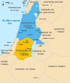 | 720 × 859 (79 കെ.ബി.) | Malus Catulus (സംവാദം | സംഭാവനകൾ) | Fixed Judah color | |
| 10:51, 13 ജൂലൈ 2010 |  | 720 × 859 (79 കെ.ബി.) | Malus Catulus (സംവാദം | സംഭാവനകൾ) | Added colors for the two kingdoms and converted their text to path and arial | |
| 23:53, 12 ജൂലൈ 2010 |  | 720 × 859 (62 കെ.ബി.) | Malus Catulus (സംവാദം | സംഭാവനകൾ) | Shrinked down the borders | |
| 19:43, 12 ജൂലൈ 2010 |  | 720 × 859 (62 കെ.ബി.) | Malus Catulus (സംവാദം | സംഭാവനകൾ) | {{Information |Description={{en|1=Map showing the ancient levant borders and ancient cities such as Urmomium and Jerash. The map also shows the region in the 9th century BCE. Notice the coastal land of Philistia, from which the name "Palestine |
ഈ പ്രമാണത്തിനു മുകളിൽ മറ്റൊരു പ്രമാണം ചേർക്കാൻ താങ്കൾക്ക് കഴിയില്ല.
പ്രമാണത്തിന്റെ ഉപയോഗം
താഴെ കാണുന്ന 39 താളുകളിൽ ഈ ചിത്രം ഉപയോഗിക്കുന്നു:
- Jewish history
- User:Geagea/Israel/2017 February 10
- User:Malus Catulus
- File:Amón 830-es.svg
- File:Edom 830-es.svg
- File:Israel and Judah.png
- File:Kingdoms around Israel 830 map-el.svg
- File:Kingdoms around Israel 830 map-nl.svg
- File:Kingdoms around Israel 830 map-pt.svg
- File:Kingdoms around Israel 830 map.svg
- File:Kingdoms around Israel 830 map mk.svg
- File:Kingdoms around Israel 830 map sh.svg
- File:Kingdoms around Israel 830 map sr.svg
- File:Kingdoms of Israel and Judah map 830-ar.svg
- File:Kingdoms of Israel and Judah map 830-ca.svg
- File:Kingdoms of Israel and Judah map 830-el.svg
- File:Kingdoms of Israel and Judah map 830-es.svg
- File:Kingdoms of Israel and Judah map 830-hu.svg
- File:Kingdoms of Israel and Judah map 830-id.svg
- File:Kingdoms of Israel and Judah map 830-nl.svg
- File:Kingdoms of Israel and Judah map 830-pt.svg
- File:Kingdoms of Israel and Judah map 830.svg
- File:Kingdoms of Israel and Judah map 830 zh.svg
- File:Kingdoms of the Levant Map 830.xcf
- File:Levant 01.PNG
- File:Levant 830-HE-2.svg
- File:Levant 830-HE.svg
- File:Levant 830-rus.svg
- File:Levant 830.svg
- File:Levant 830 map-pt.svg
- File:Levant hu.svg
- File:Levante 830-es.svg
- File:Moab 830-es.svg
- File:Royaumes autour d'Israel en 830.svg
- File:イスラエル王国とユダ王国.svg
- Template:Other versions/Kingdoms around Israel 830 map
- Template:Other versions/Kingdoms of Israel and Juda map 830
- Category:Kingdom of Israel
- Category:Kingdom of Judah
പ്രമാണത്തിന്റെ ആഗോള ഉപയോഗം
താഴെ കൊടുത്തിരിക്കുന്ന മറ്റ് വിക്കികൾ ഈ പ്രമാണം ഉപയോഗിക്കുന്നു:
- af.wikipedia.org സംരംഭത്തിലെ ഉപയോഗം
- als.wikipedia.org സംരംഭത്തിലെ ഉപയോഗം
- arz.wikipedia.org സംരംഭത്തിലെ ഉപയോഗം
- azb.wikipedia.org സംരംഭത്തിലെ ഉപയോഗം
- az.wikipedia.org സംരംഭത്തിലെ ഉപയോഗം
- bar.wikipedia.org സംരംഭത്തിലെ ഉപയോഗം
- be-tarask.wikipedia.org സംരംഭത്തിലെ ഉപയോഗം
- be.wikipedia.org സംരംഭത്തിലെ ഉപയോഗം
- bg.wikipedia.org സംരംഭത്തിലെ ഉപയോഗം
- bn.wikipedia.org സംരംഭത്തിലെ ഉപയോഗം
- br.wikipedia.org സംരംഭത്തിലെ ഉപയോഗം
- bs.wikipedia.org സംരംഭത്തിലെ ഉപയോഗം
- bxr.wikipedia.org സംരംഭത്തിലെ ഉപയോഗം
- cdo.wikipedia.org സംരംഭത്തിലെ ഉപയോഗം
- cs.wikipedia.org സംരംഭത്തിലെ ഉപയോഗം
- da.wikipedia.org സംരംഭത്തിലെ ഉപയോഗം
- de.wikipedia.org സംരംഭത്തിലെ ഉപയോഗം
- de.wikibooks.org സംരംഭത്തിലെ ഉപയോഗം
- en.wikipedia.org സംരംഭത്തിലെ ഉപയോഗം
ഈ പ്രമാണത്തിന്റെ കൂടുതൽ ആഗോള ഉപയോഗം കാണുക.
മെറ്റാഡാറ്റ
ഡിജിറ്റൽ ക്യാമറയോ, സ്കാനറോ ഉപയോഗിച്ച് നിർമ്മിച്ചപ്പോഴോ ഡിജിറ്റൈസ് ചെയ്തപ്പോഴോ ചേർക്കപ്പെട്ട അധികവിവരങ്ങൾ ഈ പ്രമാണത്തിലുണ്ട്. ഈ പ്രമാണം അതിന്റെ ആദ്യസ്ഥിതിയിൽ നിന്നും മാറ്റിയിട്ടുണ്ടെങ്കിൽ, ചില വിവരങ്ങൾ ഇപ്പോഴുള്ള പ്രമാണത്തെ പൂർണ്ണമായി പ്രതിനിധീകരിക്കണമെന്നില്ല.
| വീതി | 719.58716 |
|---|---|
| ഉയരം | 858.64001 |


