File:Korean war 1950-1953.gif
Vai alla navigazione
Vai alla ricerca
Dimensioni di questa anteprima: 387 × 600 pixel. Altre risoluzioni: 155 × 240 pixel | 562 × 871 pixel.
File originale (562 × 871 pixel, dimensione del file: 1,32 MB, tipo MIME: image/gif, ciclico, 20 frame, 30 s)
Didascalie
Didascalie
Aggiungi una brevissima spiegazione di ciò che questo file rappresenta
It represents the land Korea gained
Dettagli[modifica]
| Descrizione |
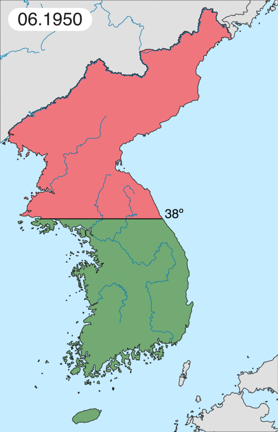
English: Map of Korean war from May 1950 to July 1951, showing:
Français : Carte de la guerre de Corée de mai 1950 à juillet 1951, montrant:
Deutsch: Karte des Koreakriegs von Mai 1950 bis Juli 1951, abgebildet:
Italiano: Mappa della guerra di Corea dal maggio 1950 al luglio 1951, rappresentante:
|
| Data | |
| Fonte | Opera propria |
| Autore | Leomonaci98 |
Licenza[modifica]
Io, detentore del copyright su quest'opera, dichiaro di pubblicarla con le seguenti licenze:

|
È permesso copiare, distribuire e/o modificare questo documento in base ai termini della GNU Free Documentation License, Versione 1.2 o successive pubblicata dalla Free Software Foundation; senza alcuna sezione non modificabile, senza testo di copertina e senza testo di quarta di copertina. Una copia della licenza è inclusa nella sezione intitolata Testo della GNU Free Documentation License. |
| Questo file è disponibile in base alla licenza Creative Commons Attribuzione-Condividi allo stesso modo 3.0 Unported | ||
| ||
| Questo tag di copyright è stato aggiunto nell'ambito dell'aggiornamento della licenza dei progetti Wikimedia. |
Puoi scegliere la licenza che preferisci.
Cronologia del file
Fare clic su un gruppo data/ora per vedere il file come si presentava nel momento indicato.
| Data/Ora | Miniatura | Dimensioni | Utente | Commento | |
|---|---|---|---|---|---|
| attuale | 20:20, 16 feb 2020 | | 562 × 871 (1,32 MB) | Leomonaci98 (discussione | contributi) | Graphic update |
| 01:02, 1 mag 2013 |  | 227 × 400 (85 KB) | Spesh531 (discussione | contributi) | update for every month | |
| 08:47, 9 giu 2006 |  | 227 × 400 (37 KB) | Roke~commonswiki (discussione | contributi) | rm white | |
| 06:25, 8 giu 2006 |  | 227 × 400 (37 KB) | Roke~commonswiki (discussione | contributi) | add OngJin peninsula after comment, also blank frame at end | |
| 15:14, 5 giu 2006 |  | 227 × 400 (37 KB) | Roke~commonswiki (discussione | contributi) | Korean war, showing North Korean, Chinese and communist forces (red); South Korean, US and United Nations forces (green). Category: Korean War Category: Animated maps |
Impossibile sovrascrivere questo file.
Utilizzo del file
Le seguenti 5 pagine usano questo file:
Utilizzo globale del file
Anche i seguenti wiki usano questo file:
- Usato nelle seguenti pagine di af.wikipedia.org:
- Usato nelle seguenti pagine di az.wikipedia.org:
- Usato nelle seguenti pagine di bat-smg.wikipedia.org:
- Usato nelle seguenti pagine di bg.wikipedia.org:
- Usato nelle seguenti pagine di br.wikipedia.org:
- Usato nelle seguenti pagine di bs.wikipedia.org:
- Usato nelle seguenti pagine di ca.wikipedia.org:
- Corea del Nord
- Corea del Sud
- Ióssif Stalin
- Mao Zedong
- Winston Churchill
- Harry Truman
- Guerra de Corea
- Kim Il-sung
- Viatxeslav Mólotov
- Gueorgui Malenkov
- Douglas MacArthur
- Lavrenti Béria
- M*A*S*H (pel·lícula)
- Clement Attlee
- Mark Wayne Clark
- Zona desmilitaritzada de Corea
- República Popular d'Hongria
- Syngman Rhee
- Peng Dehuai
- Força Aèria de l'Exèrcit Popular de Corea
- Forces Armades de Corea del Nord
- Forces Armades de la República de Corea
- 65è Regiment d'Infanteria (Estats Units)
- Frontera entre Corea del Nord i Corea del Sud
- Kim Chaek
- Batalla d'Inchon
- Plantilla:Guerra de Corea
- Pak Hon-yong
- Usato nelle seguenti pagine di ckb.wikipedia.org:
- Usato nelle seguenti pagine di cs.wikipedia.org:
- Usato nelle seguenti pagine di cy.wikipedia.org:
- Usato nelle seguenti pagine di da.wikipedia.org:
- Usato nelle seguenti pagine di de.wikipedia.org:
- Usato nelle seguenti pagine di el.wikipedia.org:
- Usato nelle seguenti pagine di en.wikipedia.org:
Visualizza l'utilizzo globale di questo file.