File:Krasnodarsky Krai-admin.png
Jump to navigation
Jump to search

Size of this preview: 640 × 600 pixels. Other resolutions: 256 × 240 pixels | 820 × 768 pixels | 1,093 × 1,024 pixels | 2,185 × 2,048 pixels | 3,578 × 3,353 pixels.
Original file (3,578 × 3,353 pixels, file size: 399 KB, MIME type: image/png)
Captions
Captions
Add a one-line explanation of what this file represents
Summary[edit]
| Description |
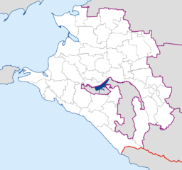
см. выше English: Administrative map of Krasnodarsky krai (Russia) in Mercator projecton cropped by 1 degree lines (36° - 42° E, 43° - 47° N).
Русский: Административная карта Краснодарского края и Адыгеи в проекции Меркатора, обрезанная ровно по градусной сетке (36° - 42° в.д., 43° - 47° с.ш.).
Українська: Адміністративна карта Краснодарського краю (Кубань) та Адигеї в проекції Меркатора, обрізана по градусним лініям (36° - 42° с.д., 43° - 47° п.ш.). |
| Date | 20 March 2007 (upload date) |
| Source | Own work |
| Author | Koryakov Yuri |
| Other versions |
Derivative works of this file: Krasnodarsky Krai-admin with numbers.png:  |
Licensing[edit]
| I, the copyright holder of this work, release this work into the public domain. This applies worldwide. In some countries this may not be legally possible; if so: I grant anyone the right to use this work for any purpose, without any conditions, unless such conditions are required by law. |
File history
Click on a date/time to view the file as it appeared at that time.
| Date/Time | Thumbnail | Dimensions | User | Comment | |
|---|---|---|---|---|---|
| current | 12:38, 23 September 2012 | | 3,578 × 3,353 (399 KB) | Mapmaster (talk | contribs) | Republik Adygeja herausgehoben |
| 17:14, 30 July 2012 |  | 3,578 × 3,353 (92 KB) | Ras67 (talk | contribs) | cropped, opt. | |
| 21:24, 20 March 2007 |  | 3,610 × 3,385 (123 KB) | Koryakov Yuri (talk | contribs) | Administrative map of Krasnodarsky krai (Russia) in Mercator projecton cropped by 1 degree lines (36 - 42 E, 43 - 47 N). |
You cannot overwrite this file.
File usage on Commons
The following 3 pages use this file:
File usage on other wikis
The following other wikis use this file:
- Usage on ar.wikipedia.org
- Usage on arz.wikipedia.org
- Usage on de.wikipedia.org
- Usage on diq.wikipedia.org
- Usage on el.wikipedia.org
- Usage on fa.wikipedia.org
- Usage on hr.wikipedia.org
- Usage on id.wikipedia.org
- Usage on jv.wikipedia.org
- Usage on mr.wikipedia.org
- Usage on nn.wikipedia.org
- Mal:Kartposisjon Krasnodar kraj
- Krasnodar
- Sotsji
- Novorossijsk
- Armavir i Russland
- Kropotkin i Krasnodar kraj
- Tikhoretsk
- Tuapse
- Slavjansk-na-Kubani
- Krymsk
- Beloretsjensk
- Anapa
- Gelendzjik
- Apsjeronsk
- Gorjatsjij Kljutsj
- Gulkevitsji
- Khadyzjensk
- Korenovsk
- Kurganinsk
- Novokubansk
- Primorsko-Akhtarsk
- Temrjuk
- Ust-Labinsk
- Usage on pl.wikipedia.org
- Usage on ru.wikimedia.org
- Usage on sco.wikipedia.org
View more global usage of this file.