File:Laptev Sea map.png
Jump to navigation
Jump to search

Size of this preview: 800 × 449 pixels. Other resolutions: 320 × 179 pixels | 640 × 359 pixels | 1,024 × 574 pixels | 1,500 × 841 pixels.
Original file (1,500 × 841 pixels, file size: 382 KB, MIME type: image/png)
Captions
Captions
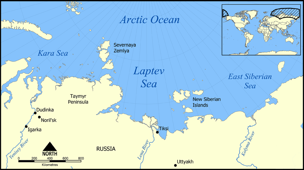
Location of the Laptev Sea north of Siberia, Russia.
Summary[edit]
| Description |
English: Location of the Laptev Sea north of Siberia, Russia. The sea is part of the Arctic Ocean, and neighbours the Kara Sea and East Siberian Sea. |
| Date | |
| Source | Own work |
| Author | NormanEinstein |

|
This locator map image could be re-created using vector graphics as an SVG file. This has several advantages; see Commons:Media for cleanup for more information. If an SVG form of this image is available, please upload it and afterwards replace this template with
{{vector version available|new image name}}.
It is recommended to name the SVG file “Laptev Sea map.svg”—then the template Vector version available (or Vva) does not need the new image name parameter. |
Licensing[edit]
I, the copyright holder of this work, hereby publish it under the following licenses:

|
Permission is granted to copy, distribute and/or modify this document under the terms of the GNU Free Documentation License, Version 1.2 or any later version published by the Free Software Foundation; with no Invariant Sections, no Front-Cover Texts, and no Back-Cover Texts. A copy of the license is included in the section entitled GNU Free Documentation License. |
| This file is licensed under the Creative Commons Attribution-Share Alike 3.0 Unported license. | ||
| ||
| This licensing tag was added to this file as part of the GFDL licensing update. |
You may select the license of your choice.
Derivative works[edit]
Derivative works of this file:
File history
Click on a date/time to view the file as it appeared at that time.
| Date/Time | Thumbnail | Dimensions | User | Comment | |
|---|---|---|---|---|---|
| current | 21:23, 27 February 2016 | | 1,500 × 841 (382 KB) | Jahoe (talk | contribs) | Clean up png coding, stripped off large chunks of irrelevant metadata (left behind by adobe editor). Image itself unaltered. |
| 14:10, 23 March 2015 |  | 1,500 × 841 (434 KB) | RokerHRO (talk | contribs) | optipng -o7 -i0 → 25.66% decrease | |
| 21:42, 5 December 2005 |  | 1,500 × 841 (583 KB) | NormanEinstein (talk | contribs) | This map shows the location of the Laptev Sea north of Siberia, Russia. The sea is part of the Arctic Ocean, and neighbours the Kara Sea and East Siberian Sea. Created by NormanEinstein, December 5, 2005. {{GFDL-self}} Category:Maps of seas |
You cannot overwrite this file.
File usage on Commons
The following 6 pages use this file:
File usage on other wikis
The following other wikis use this file:
- Usage on af.wikipedia.org
- Usage on ar.wikipedia.org
- Usage on azb.wikipedia.org
- Usage on az.wikipedia.org
- Portal:Coğrafiya
- Taymır yarımadası
- İstifadəçi müzakirəsi:Qızılbaş
- İstifadəçi müzakirəsi:Rəşid Nurməmmədov
- Laptevlər dənizi
- Rıbnıy yarımadası
- Vikipediya:Həftənin yaxşı məqaləsi/may 2019
- Vikipediya:Həftənin yaxşı məqaləsi/18. Həftə 2019
- İstifadəçi müzakirəsi:Araz Yaquboglu/Arxiv 10
- İstifadəçi müzakirəsi:Sortilegus/Arxiv 2019
- Usage on be-tarask.wikipedia.org
- Usage on bn.wikipedia.org
- Usage on br.wikipedia.org
- Usage on bs.wikipedia.org
- Usage on ca.wikipedia.org
- Usage on cs.wikipedia.org
- Usage on cy.wikipedia.org
- Usage on da.wikipedia.org
- Usage on de.wikipedia.org
- Usage on el.wikipedia.org
- Usage on en.wikipedia.org
- Usage on en.wiktionary.org
- Usage on eo.wikipedia.org
- Usage on eu.wikipedia.org
- Usage on fa.wikipedia.org
- Usage on frr.wikipedia.org
- Usage on fr.wikipedia.org
View more global usage of this file.