File:Largest World Subdivisions Area.png
Jump to navigation
Jump to search
Size of this preview: 800 × 397 pixels. Other resolutions: 320 × 159 pixels | 640 × 318 pixels | 1,024 × 508 pixels | 1,280 × 635 pixels | 2,560 × 1,271 pixels | 4,500 × 2,234 pixels.
Original file (4,500 × 2,234 pixels, file size: 566 KB, MIME type: image/png)
Captions
Captions
Add a one-line explanation of what this file represents

|
This map image could be re-created using vector graphics as an SVG file. This has several advantages; see Commons:Media for cleanup for more information. If an SVG form of this image is available, please upload it and afterwards replace this template with
{{vector version available|new image name}}.
It is recommended to name the SVG file “Largest World Subdivisions Area.svg”—then the template Vector version available (or Vva) does not need the new image name parameter. |
Summary[edit]
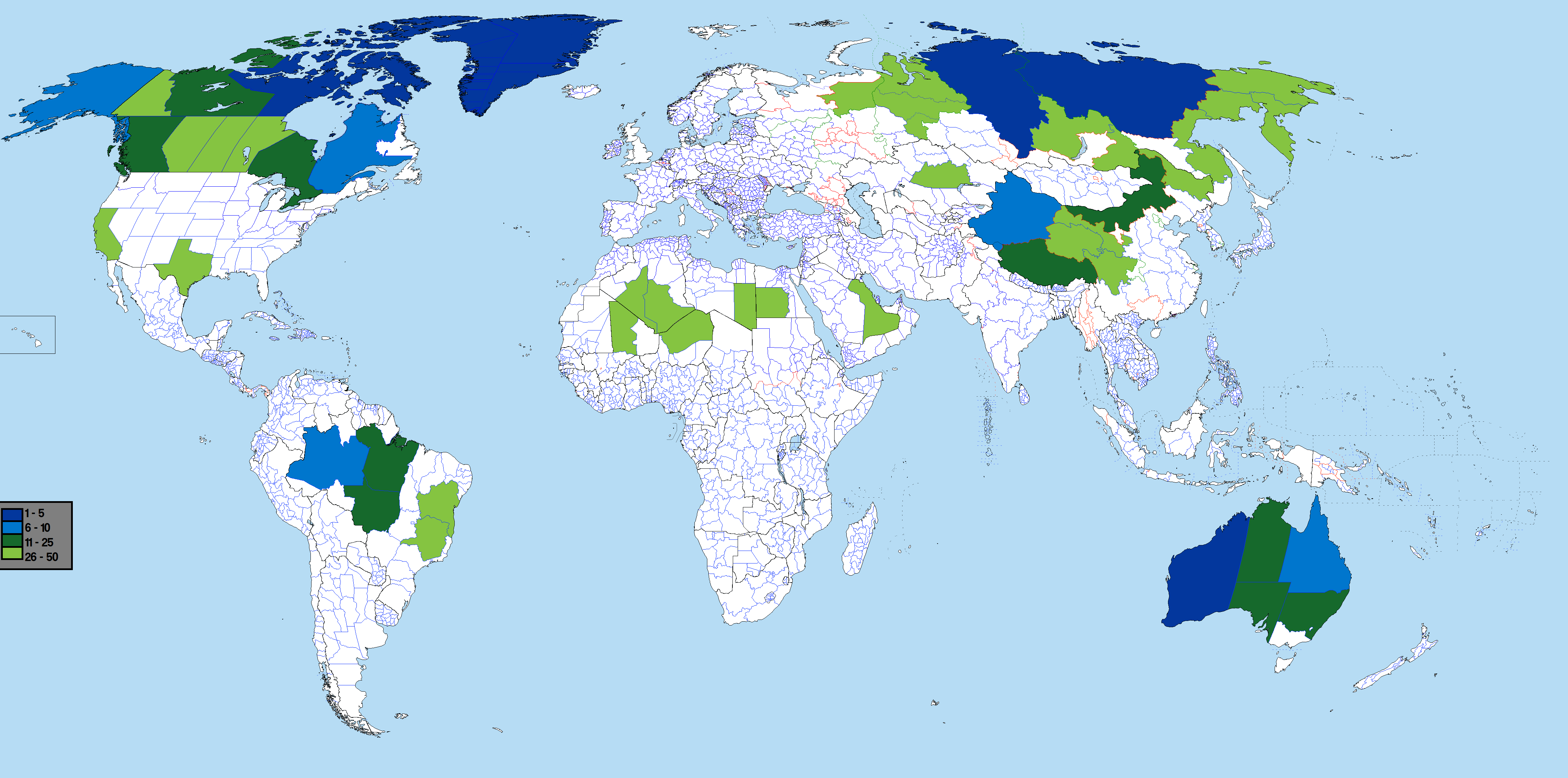
Based on Image:BlankMap-World-Subdivisions.PNG, using information from List of the largest country subdivisions by area
See also: largest subdivisions by population map
Licensing[edit]
I, the copyright holder of this work, hereby publish it under the following licenses:

|
Permission is granted to copy, distribute and/or modify this document under the terms of the GNU Free Documentation License, Version 1.2 or any later version published by the Free Software Foundation; with no Invariant Sections, no Front-Cover Texts, and no Back-Cover Texts. A copy of the license is included in the section entitled GNU Free Documentation License. |
| This file is licensed under the Creative Commons Attribution-Share Alike 3.0 Unported license. | ||
| ||
| This licensing tag was added to this file as part of the GFDL licensing update. |
You may select the license of your choice.
File history
Click on a date/time to view the file as it appeared at that time.
| Date/Time | Thumbnail | Dimensions | User | Comment | |
|---|---|---|---|---|---|
| current | 09:58, 28 February 2022 | | 4,500 × 2,234 (566 KB) | Scratchinghead (talk | contribs) | Congo provinces removed, California re-added |
| 00:35, 1 September 2019 |  | 4,500 × 2,234 (541 KB) | SpencerCS (talk | contribs) | Corrected the error. California is no longer highlighted, but the New Valley Governorate is. | |
| 20:37, 13 June 2017 |  | 4,500 × 2,234 (565 KB) | JoaoPedro10029 (talk | contribs) | Fixed: added table, removed annoying white bar in the far left and pesky colors in the lower left canton. | |
| 20:33, 13 June 2017 |  | 4,500 × 2,234 (332 KB) | JoaoPedro10029 (talk | contribs) | Bigger map, can see better the subdivisions, only problem is the DRC's subdivisions that are replaced with the 2015's ones. | |
| 15:17, 20 July 2016 |  | 1,481 × 741 (65 KB) | Andhrapur (talk | contribs) | update | |
| 00:05, 26 October 2012 |  | 1,481 × 741 (122 KB) | $200inaire (talk | contribs) | Second Fix | |
| 00:03, 26 October 2012 |  | 1,481 × 741 (122 KB) | $200inaire (talk | contribs) | Color tint | |
| 06:49, 2 September 2012 |  | 1,481 × 741 (81 KB) | ASDFGH (talk | contribs) | update | |
| 03:24, 13 April 2012 |  | 1,427 × 628 (144 KB) | $200inaire (talk | contribs) | Added the two DRC Provinces Orientale and Katanga. | |
| 17:06, 25 November 2011 |  | 1,427 × 628 (145 KB) | Дмитрий-5-Аверин (talk | contribs) | Без Борку-Эннеди-Тибести и Эр-Рияд |
You cannot overwrite this file.
File usage on Commons
There are no pages that use this file.
File usage on other wikis
The following other wikis use this file:
- Usage on ar.wikipedia.org
- Usage on bn.wikipedia.org
- Usage on ca.wikipedia.org
- Usage on fr.wikipedia.org
- Usage on hu.wikipedia.org
- Usage on ja.wikipedia.org
- Usage on os.wikipedia.org
- Usage on pt.wikipedia.org
- Usage on sq.wikipedia.org
- Usage on th.wikipedia.org
- Usage on uk.wikipedia.org
- Usage on zh.wikipedia.org