File:Latitude and longitude graticule on an ellipsoid.svg
둘러보기로 이동
검색으로 이동

SVG 파일의 PNG 형식의 미리보기 크기: 660 × 600 픽셀. 다른 해상도: 264 × 240 픽셀 | 528 × 480 픽셀 | 845 × 768 픽셀 | 1,126 × 1,024 픽셀 | 2,253 × 2,048 픽셀 | 825 × 750 픽셀
원본 파일 (SVG 파일, 실제 크기 825 × 750 픽셀, 파일 크기: 102 KB)
캡션
설명
이 파일이 나타내는 바에 대한 한 줄 설명을 추가합니다
파일 설명
[편집]
| 설명 |
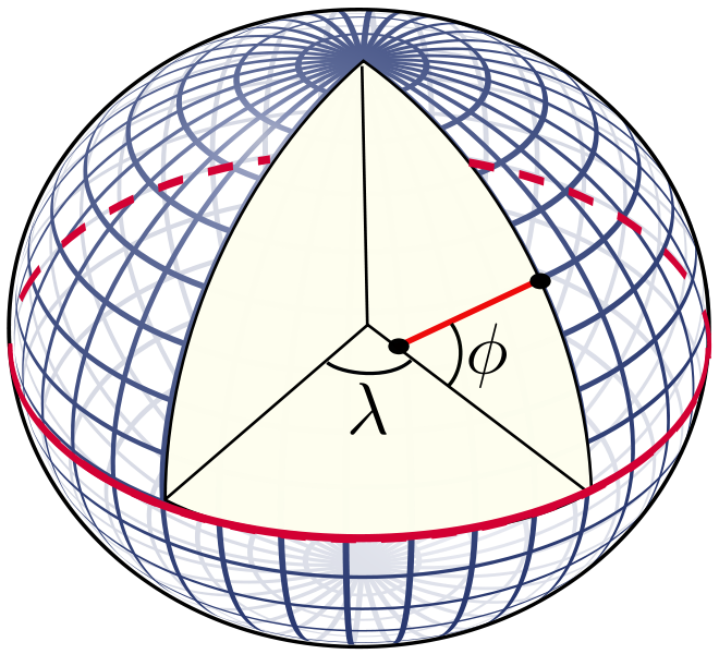
English: The definition of latitude (φ) and longitude (λ) on an ellipsoid of revolution (or spheroid). The graticule spacing is 10 degrees. The latitude is defined as the angle between the normal to the ellipsoid and the equatorial plane. |
| 날짜 | |
| 출처 | 자작 |
| 저자 | Peter Mercator |
| 다른 버전 |
The graticule was taken from the file Sphere wireframe 10deg 10r.svg. 이 파일은 다음에 의해 파생됨: Sphere wireframe 10deg 10r.svg |
| SVG 발전 | 이 SVG 파일의 소스 코드를 4가지의 실수입니다. |
라이선스
[편집]
| 나는 이 작품의 저작권자로서, 이 작품을 퍼블릭 도메인으로 모두에게 공개합니다. 이 공개 선언은 전 세계적으로 유효합니다. 만약 저작권의 포기가 법률적으로 가능하지 않은 경우, 나는 이 작품을 법적으로 허용되는 한도 내에서 누구나 자유롭게 어떤 목적으로도 제한없이 사용할 수 있도록 허용합니다. |
파일 역사
날짜/시간 링크를 클릭하면 해당 시간의 파일을 볼 수 있습니다.
| 날짜/시간 | 섬네일 | 크기 | 사용자 | 설명 | |
|---|---|---|---|---|---|
| 현재 | 2010년 12월 5일 (일) 21:20 | | 825 × 750 (102 KB) | Peter Mercator (토론 | 기여) | {{Information |Description={{en|1=The definition of latitude and longitude on an ellipsoid of revolution (or spheroid). The graticule spacing is 10 degrees. The latitude is defined as the angle between the normal to the ellipsoid and the equatorial plane. |
이 파일을 덮어쓸 수 없습니다.
이 파일을 사용하는 문서
이 파일을 사용하는 문서가 없습니다.
이 파일을 사용하고 있는 모든 위키의 문서 목록
다음 위키에서 이 파일을 사용하고 있습니다:
- bg.wikipedia.org에서 이 파일을 사용하고 있는 문서 목록
- ca.wikipedia.org에서 이 파일을 사용하고 있는 문서 목록
- cs.wikipedia.org에서 이 파일을 사용하고 있는 문서 목록
- de.wikipedia.org에서 이 파일을 사용하고 있는 문서 목록
- en.wikipedia.org에서 이 파일을 사용하고 있는 문서 목록
- Cartography
- Geodesy
- Latitude
- Navigation
- Geophysics
- Geoid
- Very-long-baseline interferometry
- Remote sensing
- Geomatics
- Photogrammetry
- Earth's orbit
- Geodetic astronomy
- Virtual globe
- Category:Geodesists
- Gravity of Earth
- Computer cartography
- Inertial navigation system
- User:Peter Mercator/Draft figures
- Template:Portal/doc/all
- Portal:Geophysics
- Geopositioning
- List of geodesists
- Template:Geodesy navbox
- Portal:Geodesy
- User:Certes/Reports/Portals
- ja.wikipedia.org에서 이 파일을 사용하고 있는 문서 목록
- ja.wikibooks.org에서 이 파일을 사용하고 있는 문서 목록
- ko.wikipedia.org에서 이 파일을 사용하고 있는 문서 목록
- nl.wikipedia.org에서 이 파일을 사용하고 있는 문서 목록
- sl.wikipedia.org에서 이 파일을 사용하고 있는 문서 목록
- ta.wikipedia.org에서 이 파일을 사용하고 있는 문서 목록
- tum.wikipedia.org에서 이 파일을 사용하고 있는 문서 목록
- zh.wikipedia.org에서 이 파일을 사용하고 있는 문서 목록