File:LesserSundaIslands A2003077 0210 250m.jpg

Original file (4,800 × 3,600 pixels, file size: 2.12 MB, MIME type: image/jpeg)
Captions
Captions
Summary[edit]
| Description |
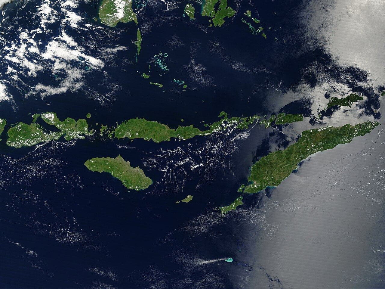
Indonesia´s Lesser Sunda Islands sparkle like green gems against the sapphire-blue waters of the Indian Ocean and Flores, Banda, Sawu, and Timor Seas. These islands form the southern border of Indonesia with Australia and stretch for 1,200 kilometers from the western island of Lombok on the left to the eastern tip of Timor, the largest island in the image. In a few places, bright turquoise-blue spots on the water mark tiny islands surrounded by shallow waters: the Kepulauan Taka´Bonerate islands in the upper center of the image, the Kepulauan Tukangbesi islands in the upper right, and the Ashmore and Cartier Islands (Australian territories) in the lower center. MODIS also detected a fire in this scene on Buton Island in the upper center part of this scene; the fire is marked in red. This true-color Terra MODIS image was acquired on March 18, 2003. Credit Jeff Schmaltz, MODIS Rapid Response Team, NASA/GSFC Sensor Terra/MODIS To view more images from NASA's Visible Earth go to: visibleearth.nasa.gov/ NASA Goddard Space Flight Center is home to the nation's largest organization of combined scientists, engineers and technologists that build spacecraft, instruments and new technology to study the Earth, the sun, our solar system, and the universe. |
| Date | |
| Source | https://visibleearth.nasa.gov/images/65632/lesser-sunda-islands-indonesia/65636l |
| Author | NASA |
Licensing[edit]
| This file is in the public domain in the United States because it was solely created by NASA. NASA copyright policy states that "NASA material is not protected by copyright unless noted". (See Template:PD-USGov, NASA copyright policy page or JPL Image Use Policy.) | ||
 |
Warnings:
|
File history
Click on a date/time to view the file as it appeared at that time.
| Date/Time | Thumbnail | Dimensions | User | Comment | |
|---|---|---|---|---|---|
| current | 14:52, 6 August 2009 | | 4,800 × 3,600 (2.12 MB) | Mario1952 (talk | contribs) | {{Information |Description=Indonesia´s Lesser Sunda Islands sparkle like green gems against the sapphire-blue waters of the Indian Ocean and Flores, Banda, Sawu, and Timor Seas. These islands form the southern border of Indonesia with Australia and stret |
You cannot overwrite this file.
File usage on Commons
The following 4 pages use this file:
.jpg&redirect=no)
File usage on other wikis
The following other wikis use this file:
- Usage on ar.wikipedia.org
- Usage on ast.wikipedia.org
- Usage on az.wikipedia.org
- Usage on ba.wikipedia.org
- Usage on bg.wikipedia.org
- Usage on ca.wikipedia.org
- Usage on en.wikipedia.org
- Usage on eo.wikipedia.org
- Usage on es.wikipedia.org
- Usage on eu.wikipedia.org
- Usage on fr.wikipedia.org
- Usage on gl.wikipedia.org
- Usage on he.wikipedia.org
- Usage on hy.wikipedia.org
- Usage on id.wikipedia.org
- Usage on mzn.wikipedia.org
- Usage on no.wikipedia.org
- Usage on pl.wikipedia.org
- Usage on pnb.wikipedia.org
- Usage on pt.wikipedia.org
- Usage on ro.wikipedia.org
- Usage on uk.wikipedia.org
- Usage on www.wikidata.org