File:LocMap Bangladesh Barisal.png
Jump to navigation
Jump to search
No higher resolution available.
LocMap_Bangladesh_Barisal.png (247 × 337 pixels, file size: 29 KB, MIME type: image/png)
Captions
Captions
Add a one-line explanation of what this file represents
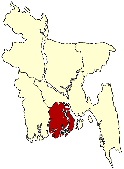
| Description | Locator map of Barisal Division in Bangladesh |
| Date | date of uploading |
| Source | PCL Maps |
| Author | CIA, Ananda |
| Permission (Reusing this file) |
CIA maps are PD. My change is put in PD |
| I, the copyright holder of this work, release this work into the public domain. This applies worldwide. In some countries this may not be legally possible; if so: I grant anyone the right to use this work for any purpose, without any conditions, unless such conditions are required by law. |
File history
Click on a date/time to view the file as it appeared at that time.
| Date/Time | Thumbnail | Dimensions | User | Comment | |
|---|---|---|---|---|---|
| current | 13:38, 23 January 2005 | | 247 × 337 (29 KB) | Ramendra~commonswiki (talk | contribs) | Barisal Division |
You cannot overwrite this file.
File usage on Commons
The following 3 pages use this file: