File:LocationCentralAfricanEmpire.png
Jump to navigation
Jump to search
No higher resolution available.
LocationCentralAfricanEmpire.png (250 × 115 pixels, file size: 6 KB, MIME type: image/png)
Captions
Captions
Add a one-line explanation of what this file represents

|
File:Central African Empire in its region.svg is a vector version of this file. It should be used in place of this PNG file when not inferior.
File:LocationCentralAfricanEmpire.png → File:Central African Empire in its region.svg
For more information, see Help:SVG. |
 |
Summary[edit]
| Description |
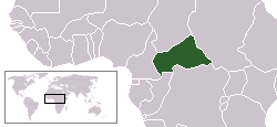
English: Locator map of the former Central African Empire — an autocratic monarchy the existed from 1976 to 1979.
|
| Date | 27 July 2007 (original upload date) |
| Source | No machine-readable source provided. Own work assumed (based on copyright claims). |
| Author | No machine-readable author provided. Hoshie assumed (based on copyright claims). |
Licensing[edit]
| This work has been released into the public domain by its author, I, Hoshie. This applies worldwide. In some countries this may not be legally possible; if so: I, Hoshie grants anyone the right to use this work for any purpose, without any conditions, unless such conditions are required by law. |
File history
Click on a date/time to view the file as it appeared at that time.
| Date/Time | Thumbnail | Dimensions | User | Comment | |
|---|---|---|---|---|---|
| current | 05:47, 27 July 2007 | | 250 × 115 (6 KB) | Hoshie (talk | contribs) | This is a map of the Central African Empire. This map is virtually the same as User:Vardion's location map of the Central African Republic with only two changes. Eritrea and |
You cannot overwrite this file.
File usage on Commons
The following page uses this file: