File:Louisiana population map.png
Jump to navigation
Jump to search
No higher resolution available.
Louisiana_population_map.png (600 × 600 pixels, file size: 219 KB, MIME type: image/png)
Captions
Captions
Add a one-line explanation of what this file represents
Summary[edit]
| Description |
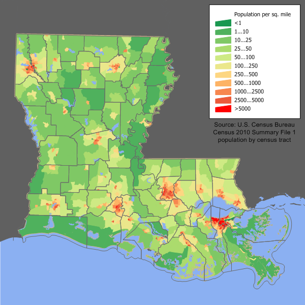
English: en:Category:U.S. State Population Maps
Louisiana state population density map based on Census 2010 data. See the data lineage for a process description. |
| Date | 11 March 2006 (original upload date) |
| Source | Transferred from en.wikipedia to Commons. |
| Author | JimIrwin at English Wikipedia |
Licensing[edit]
JimIrwin at the English Wikipedia, the copyright holder of this work, hereby publishes it under the following license:

|
Permission is granted to copy, distribute and/or modify this document under the terms of the GNU Free Documentation License, Version 1.2 or any later version published by the Free Software Foundation; with no Invariant Sections, no Front-Cover Texts, and no Back-Cover Texts. A copy of the license is included in the section entitled GNU Free Documentation License. |
| This file is licensed under the Creative Commons Attribution-Share Alike 3.0 Unported license. | ||
| Attribution: JimIrwin at the English Wikipedia | ||
| ||
| This licensing tag was added to this file as part of the GFDL licensing update. |
Original upload log[edit]
The original description page was here. All following user names refer to en.wikipedia.
- 2006-03-11 17:23 JimIrwin 680×550×8 (47691 bytes) [[Category:U.S. State Population Maps]] [[Category:Louisiana maps]] Louisiana state population density map based on Census 2000 data. See the [[User:JimIrwin/Lineage_of_population_maps|data lineage]] for a process description.
File history
Click on a date/time to view the file as it appeared at that time.
| Date/Time | Thumbnail | Dimensions | User | Comment | |
|---|---|---|---|---|---|
| current | 14:11, 11 December 2011 | | 600 × 600 (219 KB) | JimIrwin (talk | contribs) | 2010 census update |
| 19:39, 12 May 2008 |  | 680 × 550 (47 KB) | File Upload Bot (Magnus Manske) (talk | contribs) | {{BotMoveToCommons|en.wikipedia}} {{Information |Description={{en|en:Category:U.S. State Population Maps en:Category:Louisiana maps Louisiana state population density map based on Census 2000 data. See the [[:en:User:JimIrwin/Lineage_of_popula |
You cannot overwrite this file.
File usage on Commons
The following page uses this file:
File usage on other wikis
The following other wikis use this file:
- Usage on cy.wikipedia.org
- Usage on de.wikipedia.org
- Usage on en.wikipedia.org
- Usage on es.wikipedia.org
- Usage on fr.wikipedia.org
- Usage on gu.wikipedia.org
- Usage on he.wikipedia.org
- Usage on hu.wikipedia.org
- Usage on incubator.wikimedia.org
- Usage on ja.wikipedia.org
- Usage on kn.wikipedia.org
- Usage on pl.wikipedia.org
- Usage on ro.wikipedia.org
- Usage on ur.wikipedia.org