File:Magnetic North Pole Positions.svg

לקובץ המקורי (קובץ SVG, הגודל המקורי: 567 × 581 פיקסלים, גודל הקובץ: 470 ק"ב)
כיתובים
כיתובים
תקציר
[עריכה]| תיאור |
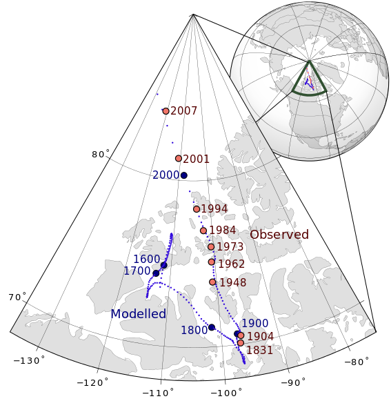
English: Magnetic north pole positions of the Earth.
Poles shown are dip poles, defined as positions where the direction of the magnetic field is vertical. Red circles mark magnetic north pole positions as determined by direct observation, blue circles mark positions modelled using the GUFM model (1590–1980) and the IGRF model (1980–2010) in 2 year increments. |
||
| תאריך יצירה | |||
| מקור |
נוצר על־ידי מעלה היצירה |
||
| יוצר | Tentotwo | ||
| SVGהתפתחות | . Inkscape עם נוצרה ה W3C-לא תקין גרפיקה וקטורית
|

| Year | Latitude | Longitude | Observer |
|---|---|---|---|
| 1831 | 70° 05' N | 96° 47' W | James Ross |
| 1904 | 70° 31' N | 96° 34' W | Amundsen |
| 1948 | 73° 54' N | 100° 54' W | Serson, Clark |
| 1962 | 75° 06' N | 100° 48' W | Loomer, Dawson |
| 1973 | 76° 00' N | 100° 36' W | Niblett, Charboneau |
| 1984 | 77° 00' N | 102° 18' W | Newitt, Niblett |
| 1994 | 78° 18' N | 104° 00' W | Newitt, Barton |
| 2001 | 81° 18' N | 110° 48' W | Newitt, Mandea, McKee |
| 2007 | 83.95° N | 120.72° W | Newitt, Chulliat, Orgeval |
GMT Source Code
[עריכה]
GMT is a Generic Mapping Tool.
<source lang="bash">
- !/bin/sh
GMT psxy -m -JE-105/90/15c -R-140/-70/65/90 -Ba10g10 --POLAR_CAP=none --BASEMAP_TYPE=plain --BASEMAP_AXES=WeS 50m_land.gmt -K -G224/224/224 > aeqd.ps GMT psxy -m -JE-105/90/15c -R-140/-70/65/90 50m_coastline.gmt -O -K -W100/100/100 >> aeqd.ps GMT psxy -m -JE-105/90/15c -R-140/-70/65/90 50m_borders.gmt -O -K -W100/100/100 >> aeqd.ps grep "2.000$\|4.000$\|6.000$\|8.000$\|0.000$" NP.xy | GMT psxy -m -JE-105/90/15c -R-140/-70/65/90 -O -K -Sc0.05c -G50/10/220 >> aeqd.ps grep "00.000$" NP.xy | GMT psxy -m -JE-105/90/15c -R-140/-70/65/90 -O -K -Sc0.5c -Gred >> aeqd.ps GMT psxy -m -JE-105/90/15c -R-140/-70/65/90 observed_north_magnetic_poles.txt -O -K -Sc0.25c -G240/117/104 -Wthick,0/0/0>> aeqd.ps GMT pstext -JE-105/90/15c -R-140/-70/65/90 -G0/0/0 -Dj0.15c/0.05c observed_north_magnetic_poles.txt -O -K >> aeqd.ps
GMT psxy -m -JG-105/75/6.5c -X9c -Y9c -Rg -Ba30g30 --POLAR_CAP=none 110m_land.gmt -O -K -G224/224/224 >> aeqd.ps GMT psxy -m -JG-105/75/6.5c -Rg 110m_coastline.gmt -O -K -W100/100/100 >> aeqd.ps GMT psxy -m -JG-105/75/6.5c -Rg 110m_borders.gmt -O -K -W100/100/100 >> aeqd.ps GMT psxy -JG-105/75/6.5c -Rg -Wfat,50/81/50 -L -Am -O -K << EOF >> aeqd.ps -140.0 65.0 -140.0 90.0 -70.0 65.0 EOF grep "2.000$\|4.000$\|6.000$\|8.000$\|0.000$" NP.xy | GMT psxy -m -JG-105/75/6.5c -Rg -O -K -Sc0.03c -G50/10/220 >> aeqd.ps GMT psxy -m -JG-105/75/6.5c -Rg observed_north_magnetic_poles.txt -O -Sc0.07c -G240/117/104 >> aeqd.ps gv aeqd.ps -orientation=landscape -resize }} }}
רישיון
[עריכה]
- הנכם רשאים:
- לשתף – להעתיק, להפיץ ולהעביר את העבודה
- לערבב בין עבודות – להתאים את העבודה
- תחת התנאים הבאים:
- ייחוס – יש לתת ייחוס הולם, לתת קישור לרישיון, ולציין אם נעשו שינויים. אפשר לעשות את זה בכל צורה סבירה, אבל לא בשום צורה שמשתמע ממנה שמעניק הרישיון תומך בך או בשימוש שלך.
- שיתוף זהה – אם תיצרו רמיקס, תשנו, או תבנו על החומר, חובה עליכם להפיץ את התרומות שלך לפי תנאי רישיון זהה או תואם למקור.
היסטוריית הקובץ
ניתן ללחוץ על תאריך/שעה כדי לראות את הקובץ כפי שנראה באותו זמן.
| תאריך/שעה | תמונה ממוזערת | ממדים | משתמש | הערה | |
|---|---|---|---|---|---|
| נוכחית | 01:57, 11 באוגוסט 2013 | | 581 × 567 (470 ק"ב) | Cavit (שיחה | תרומות) | Added 2007 observed position from Newitt et al., Location of the North Magnetic Pole in April 2007, Earth Planets Space, 61, 703–710, 2009, http://www.terrapub.co.jp/journals/EPS/pdf/2009/6106/61060703.pdf |
| 14:09, 25 בינואר 2012 |  | 581 × 567 (468 ק"ב) | Tentotwo (שיחה | תרומות) | Corrected latitude labels | |
| 13:56, 25 בינואר 2012 |  | 581 × 567 (468 ק"ב) | Tentotwo (שיחה | תרומות) | Fixed missing labels | |
| 13:34, 25 בינואר 2012 |  | 581 × 567 (470 ק"ב) | Tentotwo (שיחה | תרומות) | Reduced font size | |
| 12:57, 25 בינואר 2012 |  | 581 × 567 (469 ק"ב) | Tentotwo (שיחה | תרומות) | Corrected font for grid labels | |
| 12:55, 25 בינואר 2012 |  | 581 × 567 (469 ק"ב) | Tentotwo (שיחה | תרומות) | Smaller extent for wedge map | |
| 13:44, 23 בינואר 2012 |  | 597 × 592 (562 ק"ב) | Tentotwo (שיחה | תרומות) | Corrected font for grid labels | |
| 13:42, 23 בינואר 2012 |  | 597 × 592 (562 ק"ב) | Tentotwo (שיחה | תרומות) | Made labels slightly smaller | |
| 13:14, 23 בינואר 2012 |  | 597 × 592 (558 ק"ב) | Tentotwo (שיחה | תרומות) | Corrected SVG code | |
| 12:24, 23 בינואר 2012 |  | 597 × 592 (558 ק"ב) | Tentotwo (שיחה | תרומות) | Corrected page geometry |
אין באפשרותך לדרוס את הקובץ הזה.
שימוש בקובץ
אין דפים המשתמשים בקובץ זה.
שימוש גלובלי בקובץ
אתרי הוויקי השונים הבאים משתמשים בקובץ זה:
- שימוש באתר az.wikipedia.org
- שימוש באתר de.wikipedia.org
- שימוש באתר en.wikipedia.org
- שימוש באתר en.wikiversity.org
- שימוש באתר es.wikipedia.org
- שימוש באתר is.wikipedia.org
- שימוש באתר ja.wikipedia.org
- שימוש באתר uk.wikipedia.org