File:Majuro Satellite.PNG
Jump to navigation
Jump to search

Size of this preview: 800 × 416 pixels. Other resolutions: 320 × 167 pixels | 640 × 333 pixels | 1,024 × 533 pixels | 1,918 × 998 pixels.
Original file (1,918 × 998 pixels, file size: 5.49 MB, MIME type: image/png)
Captions
Captions
Add a one-line explanation of what this file represents
Summary[edit]
| Description |
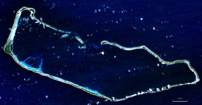
English: visible color satellite image of Majuro Atoll, Marshall Islands, Pacific Ocean |
| Date | |
| Source | NASA World Wind Screenshot (visible color) |
| Author | NASA |
Licensing[edit]
| This image is in the public domain because it is a screenshot from NASA’s globe software World Wind using a public domain layer, such as Blue Marble, MODIS, Landsat, SRTM, USGS or GLOBE.
|
 |
File history
Click on a date/time to view the file as it appeared at that time.
| Date/Time | Thumbnail | Dimensions | User | Comment | |
|---|---|---|---|---|---|
| current | 20:17, 7 August 2011 | | 1,918 × 998 (5.49 MB) | Ratzer (talk | contribs) | {{Information |Description ={{en|1=true color satellite image of Majuro Atoll, Marshall Islands, Pacific Ocean}} |Source =NASA World Wind Screenshot (true color) |Author =NASA |Date =2000 |Permission = |other_versions = }} |
You cannot overwrite this file.
File usage on Commons
There are no pages that use this file.
File usage on other wikis
The following other wikis use this file:
- Usage on be.wikipedia.org
- Usage on bn.wikipedia.org
- Usage on ceb.wikipedia.org
- Usage on de.wikipedia.org
- Usage on en.wikipedia.org
- Usage on eo.wikipedia.org
- Usage on es.wikipedia.org
- Usage on fi.wikipedia.org
- Usage on fr.wikipedia.org
- Usage on gn.wikipedia.org
- Usage on he.wikipedia.org
- Usage on hi.wikipedia.org
- Usage on id.wikipedia.org
- Usage on ja.wikipedia.org
- Usage on lt.wikipedia.org
- Usage on lv.wikipedia.org
- Usage on ml.wikipedia.org
- Usage on nl.wikipedia.org
- Usage on pl.wikipedia.org
- Usage on sat.wikipedia.org
- Usage on sd.wikipedia.org
- Usage on sh.wikipedia.org
- Usage on sl.wikipedia.org
- Usage on sr.wikipedia.org
- Usage on ur.wikipedia.org
- Usage on vep.wikipedia.org
- Usage on www.wikidata.org
- Usage on xmf.wikipedia.org
- Usage on zh.wikivoyage.org