File:Map Byzantine Empire 1025-fr.svg
קפיצה לניווט
קפיצה לחיפוש

גודל התצוגה המקדימה הזאת מסוג PNG של קובץ ה־SVG הזה: 800 × 450 פיקסלים. רזולוציות אחרות: 320 × 180 פיקסלים | 640 × 360 פיקסלים | 1,024 × 576 פיקסלים | 1,280 × 720 פיקסלים | 2,560 × 1,440 פיקסלים | 1,963 × 1,104 פיקסלים.
לקובץ המקורי (קובץ SVG, הגודל המקורי: 1,963 × 1,104 פיקסלים, גודל הקובץ: 75 ק"ב)
כיתובים
כיתובים
נא להוסיף משפט שמסביר מה הקובץ מייצג
. Inkscape עם נוצרה ה תמונה
תקציר
[עריכה]| תיאור |
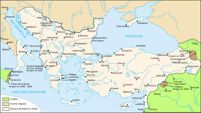
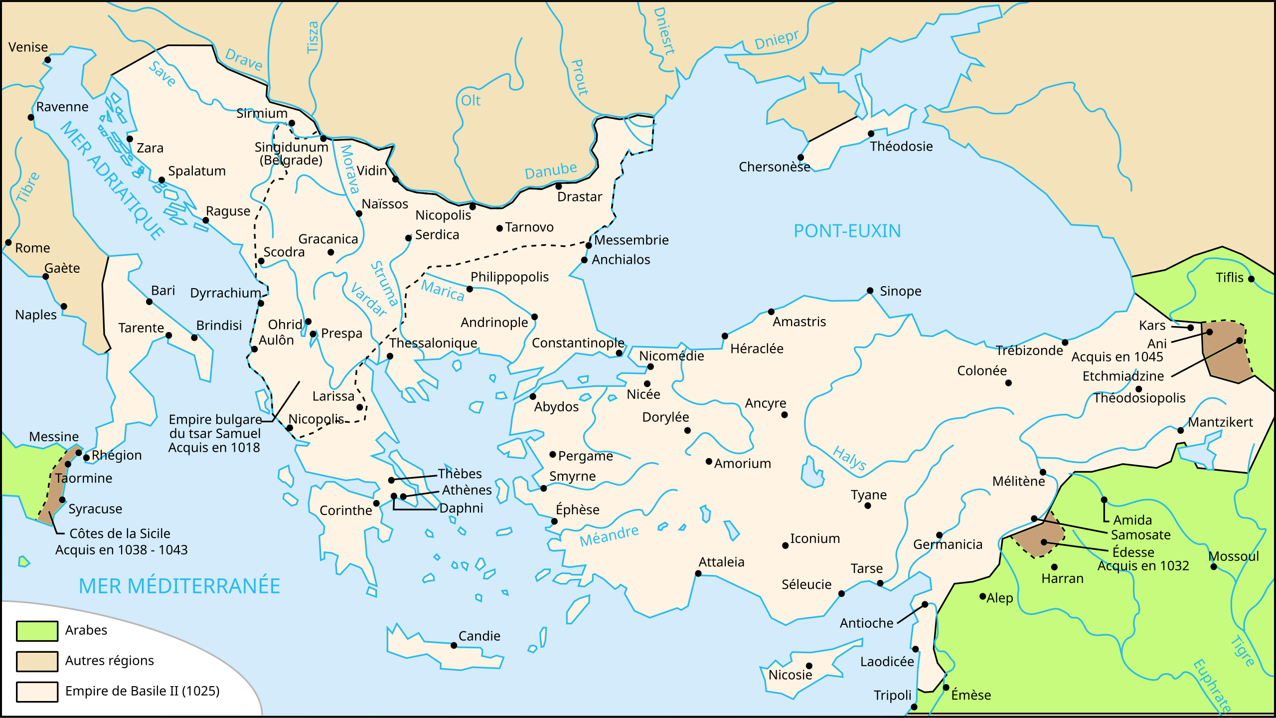
Français : L'empire byzantin à la mort de Basile II (1025). |
| תאריך יצירה | |
| מקור | Own work (data from Georges Duby, Atlas historique, page 38, map A). Image renamed from Image:Carte-Empire de Basile II.svg |
| יוצר | User:Nécropotame |
| אישורים והיתרים (שימוש חוזר בקובץ זה) |
הקובץ הזה מתפרסם לפי תנאי רישיון קריאייטיב קומונז ייחוס-שיתוף זהה 2.5 כללי.
|
| גרסאות אחרות |
[]
|


|
SVG עושה שימוש בטקסט שניתן לתרגם בקלות לשפתך. לפרטים נוספים. עבור תמונות SVG, ניתן להשתמש ב[toolforge:svgtranslate/File:Map_Byzantine_Empire_1025-fr.svglink כלי עזר] כדי לתרגם את התמונה לשפתך. |
היסטוריית הקובץ
ניתן ללחוץ על תאריך/שעה כדי לראות את הקובץ כפי שנראה באותו זמן.
| תאריך/שעה | תמונה ממוזערת | ממדים | משתמש | הערה | |
|---|---|---|---|---|---|
| נוכחית | 21:43, 1 בנובמבר 2020 | | 1,104 × 1,963 (75 ק"ב) | GrandEscogriffe (שיחה | תרומות) | corrections diverses |
| 10:40, 4 בדצמבר 2007 |  | 1,104 × 1,963 (71 ק"ב) | Salli~commonswiki (שיחה | תרומות) | update | |
| 01:42, 27 בפברואר 2007 |  | 1,104 × 1,963 (190 ק"ב) | Bibi Saint-Pol (שיחה | תרומות) | {{Inkscape}} == Summary == {{Information |Description= {{fr|L'empire byzantin tel que l'a laissé Basile II à sa mort, en 1025.}} |Source=Own work (data from Georges Duby, ''Atlas historique'' (page 38, map A). |Date=2006-08-03 |Author=[[User:Necropotame |
אין באפשרותך לדרוס את הקובץ הזה.
שימוש בקובץ
הדפים הבאים משתמשים בקובץ הזה:
- Atlas of Albania
- Atlas of Bosnia and Herzegovina
- Atlas of Croatia
- Atlas of Cyprus
- Atlas of Italy
- Atlas of Kosovo
- Atlas of Montenegro
- Atlas of North Macedonia
- Atlas of Northern Cyprus
- Atlas of Serbia
- Atlas of Vojvodina
- User:Magog the Ogre/Multilingual legend/2020 November 1-10
- File:1025'te Doğu Roma İmparatorluğu.svg
- File:1025AD-ja.svg
- File:1025AD-ko.svg
- File:1025AD-pt.svg
- File:1025AD-zh.svg
- File:1025AD.svg
- File:1025AD GRC.svg
- File:1025AD LA.svg
- File:Byzantijnse Rijk 1025-hu.svg
- File:Byzantijnse Rijk 1025.svg
- File:Byzantine during the reign of Basil II hy.svg
- File:Byzantine during the reign of Basil II sr.svg
- File:Byzantium1025.jpg
- File:Bütsants 1025.png
- File:Map Byzantine Empire 1025-ar.svg
- File:Map Byzantine Empire 1025-de.svg
- File:Map Byzantine Empire 1025-el.svg
- File:Map Byzantine Empire 1025-en.svg
- File:Map Byzantine Empire 1025-es.svg
- File:Map Byzantine Empire 1025-fr.jpg
- File:Map Byzantine Empire 1025-fr.svg
- File:Map Byzantine Empire 1025-hu.svg
- File:Map Byzantine Empire 1025-it.svg
- File:Map Byzantine Empire 1025-mk.svg
- File:Map Byzantine Empire 1025-pl.svg
- File:Map Byzantine Empire 1025-pt.svg
- File:Map Byzantine Empire 1025-zh.svg
- File:Map of the Byzantine Empire, 1025 AD.PNG
- File:Map of the Byzantine Empire, 1025 AD.svg
- File:Map of the Byzantine Empire, 1025 AD ru.svg
- Template:Other versions/Map Byzantine Empire 1025
שימוש גלובלי בקובץ
אתרי הוויקי השונים הבאים משתמשים בקובץ זה:
- שימוש באתר an.wikipedia.org
- שימוש באתר cs.wikipedia.org
- שימוש באתר en.wikipedia.org
- שימוש באתר fr.wikipedia.org
- Années 1020
- Michel VI Bringas
- Histoire de l'Empire byzantin
- Michel Ier Cérulaire
- Bataille de Manzikert
- Romain IV Diogène
- Isaac Ier Comnène
- Jean Ier Tzimiskès
- Basile II
- Romain III Argyre
- Michel IV le Paphlagonien
- Michel V
- Nicéphore III Botaniatès
- Dynastie macédonienne
- Utilisateur:Nécropotame
- Christianisme en Turquie
- Asie (province romaine)
- Utilisateur:Nécropotame/Galerie
- Histoire de la Bosnie-Herzégovine
- Wikipédia:Atelier graphique/Cartes/Archives/mars 2008
- Histoire des Pouilles
- Guerres turco-byzantines
- Histoire de l'Anatolie
- Crimée byzantine
- Empire byzantin
- Empire byzantin sous les Doukas
- שימוש באתר gl.wikipedia.org
- שימוש באתר he.wikipedia.org
- שימוש באתר it.wikipedia.org
- שימוש באתר oc.wikipedia.org
- שימוש באתר sk.wikipedia.org
- שימוש באתר tr.wikipedia.org