File:Map of Chera Country.jpg
Jump to navigation
Jump to search

Size of this preview: 721 × 599 pixels. Other resolutions: 289 × 240 pixels | 578 × 480 pixels | 924 × 768 pixels | 1,232 × 1,024 pixels | 2,464 × 2,048 pixels | 2,670 × 2,219 pixels.
Original file (2,670 × 2,219 pixels, file size: 890 KB, MIME type: image/jpeg)
Captions
Captions
Add a one-line explanation of what this file represents
Summary
[edit]
| Description |
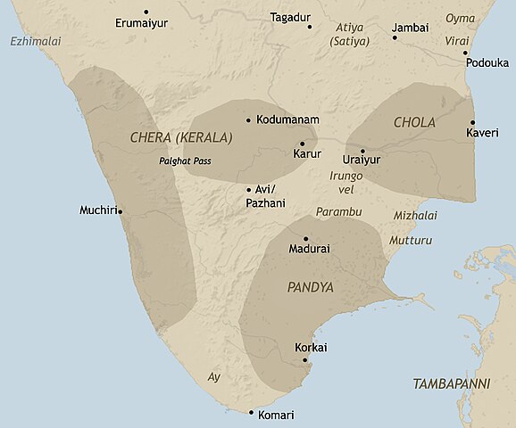
English: An approximate representation of early historic south India
|
| Date | |
| Source | Own work |
| Author | Adapted from the maps by Y. Subbarayalu for Rajan Gurukkal |
Licensing
[edit]
I, the copyright holder of this work, hereby publish it under the following license:
This file is licensed under the Creative Commons Attribution-Share Alike 3.0 Unported license.
- You are free:
- to share – to copy, distribute and transmit the work
- to remix – to adapt the work
- Under the following conditions:
- attribution – You must give appropriate credit, provide a link to the license, and indicate if changes were made. You may do so in any reasonable manner, but not in any way that suggests the licensor endorses you or your use.
- share alike – If you remix, transform, or build upon the material, you must distribute your contributions under the same or compatible license as the original.
File history
Click on a date/time to view the file as it appeared at that time.
| Date/Time | Thumbnail | Dimensions | User | Comment | |
|---|---|---|---|---|---|
| current | 05:37, 20 March 2020 | | 2,670 × 2,219 (890 KB) | StephenPaa (talk | contribs) | Added boundaries |
| 12:03, 3 February 2020 |  | 2,670 × 2,254 (1.61 MB) | StephenPaa (talk | contribs) | Boundaries added. | |
| 05:28, 6 September 2019 |  | 2,000 × 1,656 (320 KB) | StephenPaa (talk | contribs) | Boundaries removed. | |
| 12:00, 2 March 2012 |  | 2,000 × 1,333 (755 KB) | Pepper Black (talk | contribs) |
You cannot overwrite this file.
File usage on Commons
The following 3 pages use this file:
File usage on other wikis
The following other wikis use this file:
- Usage on ar.wikipedia.org
- Usage on ca.wikipedia.org
- Usage on en.wikipedia.org
- Usage on hi.wikipedia.org
- Usage on hu.wikipedia.org
- Usage on it.wikipedia.org
- Usage on ka.wikipedia.org
- Usage on ko.wikipedia.org
- Usage on ml.wikipedia.org
- Usage on ta.wikipedia.org
- Usage on vi.wikipedia.org
- Usage on zh.wikipedia.org