File:Map of Inner Asia (SRI).svg
Jump to navigation
Jump to search

Size of this PNG preview of this SVG file: 800 × 430 pixels. Other resolutions: 320 × 172 pixels | 640 × 344 pixels | 1,024 × 551 pixels | 1,280 × 688 pixels | 2,560 × 1,376 pixels | 1,300 × 699 pixels.
Original file (SVG file, nominally 1,300 × 699 pixels, file size: 6.62 MB)
Captions
Captions
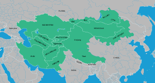
Map of Inner Asia, locating the extent of the area studied by the Sinor Research Institute for Inner Asian Studies, located at Indiana University in the USA.
Summary
[edit].svg&action=edit§ion=1)
| Description |
English: Map of Inner Asia, locating the extent of the area studied by the Sinor Research Institute for Inner Asian Studies, located at Indiana University in the USA.
Based on https://commons.wikimedia.org/wiki/File:Blank_Map_World_Secondary_Political_Divisions.svg and https://commons.wikimedia.org/wiki/File:BlankMap-World6.svg |
| Date | |
| Source | http://digitalmongolia.org/item/3bfd6968-94f4-4553-bcc6-a9c84e16a71e/index-en.html |
| Author | Eric Thrift |
Licensing
[edit].svg&action=edit§ion=2)
| This work has been released into the public domain by its author, Eric Thrift. This applies worldwide. In some countries this may not be legally possible; if so: Eric Thrift grants anyone the right to use this work for any purpose, without any conditions, unless such conditions are required by law.
|
File history
Click on a date/time to view the file as it appeared at that time.
| Date/Time | Thumbnail | Dimensions | User | Comment | |
|---|---|---|---|---|---|
| current | 21:08, 31 July 2021 | | 1,300 × 699 (6.62 MB) | Zoozaz1 (talk | contribs) | Uploaded a work by Eric Thrift from http://digitalmongolia.org/item/3bfd6968-94f4-4553-bcc6-a9c84e16a71e/index-en.html with UploadWizard |
You cannot overwrite this file.
File usage on Commons
The following page uses this file:
File usage on other wikis
The following other wikis use this file:
- Usage on ar.wikipedia.org
- Usage on el.wikipedia.org
- Usage on en.wikipedia.org
- Usage on fr.wikipedia.org
- Usage on ta.wikipedia.org
- Usage on tr.wikipedia.org
- Usage on vi.wikipedia.org
- Usage on www.wikidata.org
- Usage on zh.wikipedia.org
.svg&oldid=640484774)