File:Map of Nazi concentration camps.jpg
Jump to navigation
Jump to search

Size of this preview: 491 × 600 pixels. Other resolutions: 196 × 240 pixels | 393 × 480 pixels | 628 × 768 pixels | 838 × 1,024 pixels | 2,419 × 2,956 pixels.
Original file (2,419 × 2,956 pixels, file size: 4.74 MB, MIME type: image/jpeg)
Captions
Captions
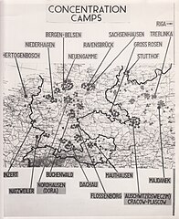
Map of Nazi concentration camps exhibited at Pohl Trial
Summary[edit]
| Description |
English: Map of Nazi concentration camps exhibited at Pohl Trial, 8 April 1947-3 November 1947 (fourth of the Subsequent Nuremberg Trials) held at the Palace of Justice, Nuremberg |
| Date | |
| Source | https://catalog.archives.gov/id/169155812 |
| Author | OMGUS Military Tribunal |
Licensing[edit]
This work is in the public domain in the United States because it is a work prepared by an officer or employee of the United States Government as part of that person’s official duties under the terms of Title 17, Chapter 1, Section 105 of the US Code.
Note: This only applies to original works of the Federal Government and not to the work of any individual U.S. state, territory, commonwealth, county, municipality, or any other subdivision. This template also does not apply to postage stamp designs published by the United States Postal Service since 1978. (See § 313.6(C)(1) of Compendium of U.S. Copyright Office Practices). It also does not apply to certain US coins; see The US Mint Terms of Use.
|
 | |
| This file has been identified as being free of known restrictions under copyright law, including all related and neighboring rights. | ||
File history
Click on a date/time to view the file as it appeared at that time.
| Date/Time | Thumbnail | Dimensions | User | Comment | |
|---|---|---|---|---|---|
| current | 01:37, 26 June 2021 | | 2,419 × 2,956 (4.74 MB) | Dawn.maria.miller (talk | contribs) | Uploaded a work by OMGUS Military Tribunal from https://catalog.archives.gov/id/169155812 with UploadWizard |
You cannot overwrite this file.
File usage on Commons
The following 8 pages use this file:
- Category:Bergen-Belsen concentration camp
- Category:Gross-Rosen concentration camp
- Category:Neuengamme concentration camp
- Category:Prisoners of Ravensbrück concentration camp
- Category:Prisoners of Sachsenhausen concentration camp
- Category:Ravensbrück concentration camp
- Category:Sachsenhausen concentration camp
- Category:Stutthof concentration camp
File usage on other wikis
The following other wikis use this file:
- Usage on bg.wikipedia.org
- Usage on ca.wikipedia.org
- Usage on de.wikipedia.org
- Usage on ga.wikipedia.org
- Usage on gl.wikipedia.org
- Usage on hu.wikipedia.org
- Usage on ro.wikipedia.org
- Usage on uk.wikipedia.org
- Usage on www.wikidata.org