File:Map of Rohingya people in Rakhine State.png
Pereiti į navigaciją
Jump to search
Šios peržiūros dydis: 345 × 600 taškų. Kitos 3 rezoliucijos: 138 × 240 taškų | 276 × 480 taškų | 651 × 1 132 taškų.
Pradinė rinkmena (651 × 1 132 taškų, rinkmenos dydis: 61 KiB, MIME tipas: image/png)
Captions
Captions
Add a one-line explanation of what this file represents
Aprašymas
[keisti]
| Aprašymas |
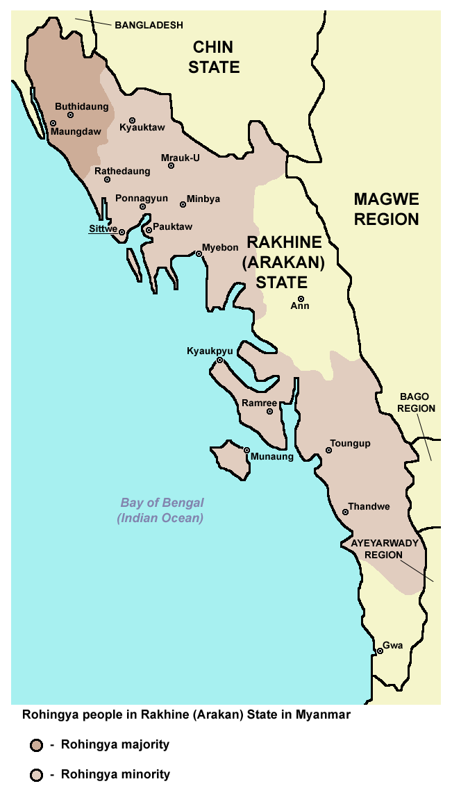
English: Rohingya people in Rakhine (Arakan) State in Myanmar. |
| Data | |
| Šaltinis | Mano darbas |
| Autorius | PANONIAN |
Licencija
[keisti]
Aš, šio darbo autoriaus teisių savininkas, publikuoju jį su šia licencija:
| Šis failas prieinamas pagal Creative Commons CC0 1.0 Universal Public Domain Dedication. | |
| Asmuo, kuris susiejo darbą su šiuo dokumentu, nusprendė darbą pateikti Commons, atsisakydamas visų savo autoriaus teisių į darbą visame pasaulyje bei visų susijusių ar gretutinių teisių, kurias jis ar ji turėjo, tiek, kiek leidžia įstatymas. Darbai pagal CC0 atsisakymą nereikalauja autoriaus paminėjimo. Kai darbas cituojamas (naudojamas kitur), neprivalote gauti autoriaus patvirtinimo.
|
References
[keisti]
Demographic data:
- http://reliefweb.int/report/myanmar/humanitarian-crisis-deepens-arakan-state ("This is in contrast to Buthidaung and Maungdaw townships which have a large Rohingya majority.")
- http://csis.org/publication/separating-fact-fiction-about-myanmars-rohingya ("Most of this population lives in the townships of Maungdaw and Buthidaung, where Rohingya are the majority")
- http://sometimemaybe.blogspot.com/2009/07/burma-ii.html ("Fear is said to reign not only in Rakhine towns and villages but also areas with Rohingya majorities—including Maungdaw Township, where more than 90 percent of the 493,000 inhabitants are Rohingya."..."One other township in Arakan State has a large Rohingya majority—Buthidaung, where more than 80 percent of the 279,000 inhabitants are Rohingya.")
- http://library.islamweb.net/emainpage/articles/180009/mass-graves-for-myanmars-rohingya ("or even the local busses that run Buthidaung to Maungdaw, two Rohingya-majority states.")
- http://www.aljazeera.com/indepth/features/2012/08/201288114724103607.html ("or even the local busses that run from Buthidaung to Maungdaw, two Rohingya-majority states.")
- https://www.hrw.org/news/2012/11/17/burma-satellite-images-show-widespread-attacks-rohingya ("All four districts of Arakan State – Sittwe, Maungdaw, Kyauk Pyu, and Thandwe – have experienced violence since June 2012. Violence between Arakanese Buddhists and Rohingya Muslims reignited on October 21 and continued to some extent all week in 9 of the state’s 17 townships: Pauktaw, Mrauk-U, Myebon, Kyauk Pyu, Ramree, Kyauktaw, Minbya, Rathedaung, and Thandwe. Four other townships experienced serious violence in June and thereafter: Sittwe, Maungdaw, Buthidaung, and Toungop.")
- http://www.restlessbeings.org/projects/rohingya/burmese-army-allow-further-2300-rohingya-to-become-displaced ("This second round of violence that began on the 21st of October were targeted at more remote villages where, whilst Rohingya villages were found, the townships were largely Rakhine populated. In Minbya, Mrauk Oo, Pauk Taw, Kyauk Taw, Kyauk Pyu and Rathedaung.")
- http://hlaoo1980.blogspot.com/2012/06/bengali-cleansing-in-arrakan.html ("There are 17 townships in the Arrakan State. Except the Bengali-free Taunggup, Ann, and Gwa townships Bengali immigrants from the extremely-crowded Bangladesh across the border inhabit the 14 townships together with the native Buddhist Yakhines.")
- http://loveandntolerance.blogspot.com/2012/10/the-concrete-solution-for-rohingya.html ("Nearly one million Rohingyas in 14 townships of Arakan State")
- https://rohingyaonlinenewsgroup.wordpress.com/2012/10/28/president-thein-sein-ready-to-declare-a-new-rule-of-law-in-rakhine-state/ ("Before and since the timely establishment of the RNDP party, its ultimate goal has been to drive out Rohingya Muslims from all 14 townships of Rakhine state and then to establish The Great Rakhine Union State")
- https://www.usatoday.com/story/news/world/2013/03/30/myanmar-govt-religious-riots/2037853/ ("It said there were 163 incidents of violence in 15 townships in the country")
Maps of Rakhine State:
- http://www.myanmars.net/myanmar-map/rakhine.jpg
- http://www.edenhilltravels.com/wp-content/uploads/2013/08/rakhine-modified.jpg
- http://www.rfa.org/english/news/myanmar/violence-10252012182913.html/rakhine-map-new-390.jpg
- http://www.asterism.info/states/7/map.jpg
- http://www.allthingsburmese.com/images/Rakhine%20State%20Map.gif
- http://www.guideformyanmar.com/images/touristplace/rakhine_state.jpg
- https://arakanindobhasa.files.wordpress.com/2009/11/12.jpg
- http://reliefweb.int/sites/reliefweb.int/files/resources/map_2466.pdf
- http://maps.maphill.com/burma/arakan-rakhine/maps/savanna-style-map/savanna-style-map-of-arakan-rakhine.jpg
- http://maps.maphill.com/burma/arakan-rakhine/maps/satellite-map/cropped-outside/satellite-map-of-arakan-rakhine-cropped-outside.jpg
- http://maps.maphill.com/burma/arakan-rakhine/maps/shaded-relief-map/shaded-relief-map-of-arakan-rakhine.jpg
- http://www.burmalibrary.org/docs08/HRDU_YB-2008/multimedia/maps/townships.jpg
Rinkmenos istorija
Paspauskite ant datos/laiko, kad pamatytumėte rinkmeną tokią, kokia ji buvo tuo metu.
| Data/Laikas | Miniatiūra | Matmenys | Naudotojas | Paaiškinimas | |
|---|---|---|---|---|---|
| dabartinis | 16:42, 16 balandžio 2017 | | 651 × 1 132 (61 KiB) | PANONIAN (aptarimas | indėlis) | Reverted to version as of 12:27, 4 July 2015 (UTC) - pointless change, not an improvement, please explain on talk page why image with no border would be better |
| 00:22, 14 balandžio 2017 |  | 620 × 1 000 (59 KiB) | Haffaz (aptarimas | indėlis) | Made legend clearer | |
| 07:09, 11 balandžio 2017 |  | 619 × 1 117 (32 KiB) | Haffaz (aptarimas | indėlis) | removed white space and centered legend | |
| 12:27, 4 liepos 2015 |  | 651 × 1 132 (61 KiB) | PANONIAN (aptarimas | indėlis) | {{Information |Description ={{en|1=Rohingya people in Rakhine (Arakan) State in Myanmar.}} |Source ={{own}} |Author =PANONIAN |Date =2015 |Permission = |other_versions = }} |
Jūs negalite perrašyti šios rinkmenos.
Rinkmenos naudojimas
Šie puslapiai naudoja šią rinkmeną:
- File:Map of Maungdaw District in Rakhine State (Arakan).png
- File:Rakhine02 rohingya people.png (failo peradresavimas)
.png)
Visuotinis rinkmenos naudojimas
Ši rinkmena naudojama šiose viki svetainėse:
- Naudojama af.wikipedia.org
- Naudojama azb.wikipedia.org
- Naudojama bn.wikipedia.org
- Naudojama ca.wikipedia.org
- Naudojama de.wikipedia.org
- Naudojama diq.wikipedia.org
- Naudojama en.wikipedia.org
- Naudojama es.wikipedia.org
- Naudojama ga.wikipedia.org
- Naudojama hr.wikipedia.org
- Naudojama hu.wikipedia.org
- Naudojama id.wikipedia.org
- Naudojama is.wikipedia.org
- Naudojama lt.wikipedia.org
- Naudojama mk.wikipedia.org
- Naudojama mnw.wikipedia.org
- Naudojama pa.wikipedia.org
- Naudojama pnb.wikipedia.org
- Naudojama ru.wikipedia.org
- Naudojama sh.wikipedia.org
- Naudojama sr.wikipedia.org
- Naudojama tl.wikipedia.org
- Naudojama tr.wikipedia.org
- Naudojama uk.wikipedia.org
- Naudojama ur.wikipedia.org
- Naudojama vi.wikipedia.org
- Naudojama zh.wikipedia.org