File:Map of Trans-African Highway System with South Sudan included 2019.png
Jump to navigation
Jump to search

Size of this preview: 600 × 599 pixels. Other resolutions: 240 × 240 pixels | 615 × 614 pixels.
Original file (615 × 614 pixels, file size: 185 KB, MIME type: image/png)
Captions
Captions
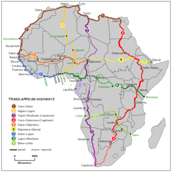
Trans-African Highway System 2019

|
This map image could be re-created using vector graphics as an SVG file. This has several advantages; see Commons:Media for cleanup for more information. If an SVG form of this image is available, please upload it and afterwards replace this template with
{{vector version available|new image name}}.
It is recommended to name the SVG file “Map of Trans-African Highway System with South Sudan included 2019.svg”—then the template Vector version available (or Vva) does not need the new image name parameter. |
Summary
[edit]
| Description |
English: Shows Trans-African Highway System with paved roads shown as of 2019, drawing on new maps. |
| Date | |
| Source | File:Map_of_Trans-African_Highways.PNG - modified |
| Author | Rexparry sydney |
Licensing
[edit]
This file is licensed under the Creative Commons Attribution-Share Alike 3.0 Unported license.
- You are free:
- to share – to copy, distribute and transmit the work
- to remix – to adapt the work
- Under the following conditions:
- attribution – You must give appropriate credit, provide a link to the license, and indicate if changes were made. You may do so in any reasonable manner, but not in any way that suggests the licensor endorses you or your use.
- share alike – If you remix, transform, or build upon the material, you must distribute your contributions under the same or compatible license as the original.
File history
Click on a date/time to view the file as it appeared at that time.
| Date/Time | Thumbnail | Dimensions | User | Comment | |
|---|---|---|---|---|---|
| current | 22:41, 5 December 2019 | | 615 × 614 (185 KB) | Arrecife (talk | contribs) | User created page with UploadWizard |
You cannot overwrite this file.
File usage on Commons
The following 3 pages use this file:
File usage on other wikis
The following other wikis use this file:
- Usage on ca.wikipedia.org
- Usage on en.wikipedia.org
- Trans–West African Coastal Highway
- Trans-Sahara Highway
- Trans-Sahelian Highway
- Trans-African Highway network
- Cairo–Dakar Highway
- N'Djamena–Djibouti Highway
- Lagos–Mombasa Highway
- Beira–Lobito Highway
- Tripoli–Cape Town Highway
- Cairo–Cape Town Highway
- Template:Trans-African Highway network
- User talk:Gidonb/Archive 2023
- Usage on ja.wikipedia.org
- Usage on uk.wikipedia.org
- Usage on www.wikidata.org