File:Map of USA with state names.svg
둘러보기로 이동
검색으로 이동

SVG 파일의 PNG 형식의 미리보기 크기: 800 × 495 픽셀. 다른 해상도: 320 × 198 픽셀 | 640 × 396 픽셀 | 1,024 × 633 픽셀 | 1,280 × 791 픽셀 | 2,560 × 1,583 픽셀 | 959 × 593 픽셀
원본 파일 (SVG 파일, 실제 크기 959 × 593 픽셀, 파일 크기: 984 KB)
캡션
설명
이 파일이 나타내는 바에 대한 한 줄 설명을 추가합니다
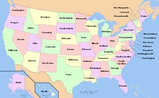
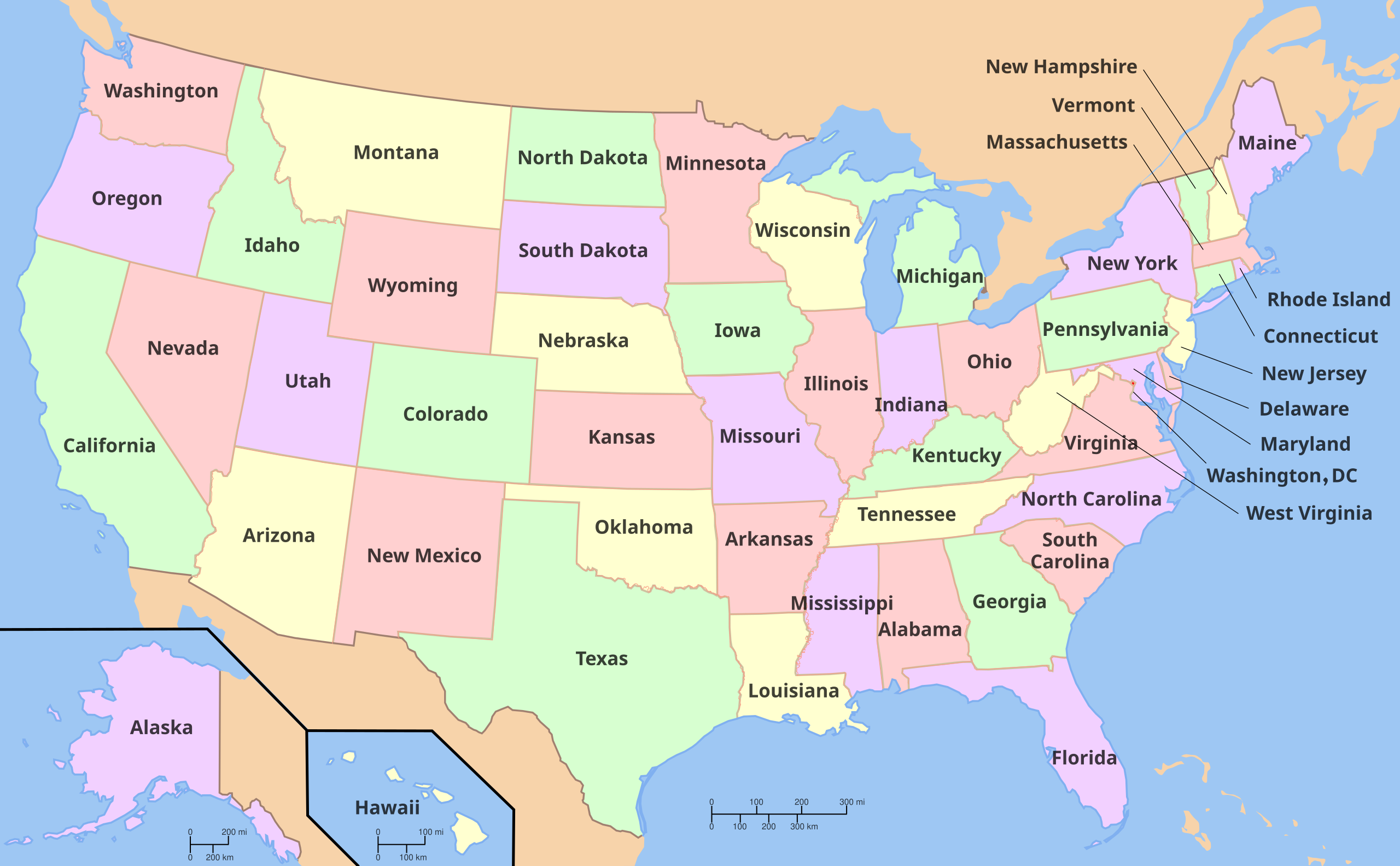
States of the United States
파일 설명
| 설명 |
English: A map of the United States, with state names (and Washington D.C.). |
| 출처 | see below |
| 저자 |
The original was edited by Andrew c to include Nova Scotia, PEI, Bahamas, and scale key. It was originally uploaded to the English Wikipedia with the same title by Wapcaplet:
|
| SVG 발전 | 이 SVG 지도는은 SVG의 <switch> 요소를 사용하는 것으로 번역되어 있습니다: 모든 번역은 동일 파일 안에 저장되어 있습니다. |
Versions
Non-modifiable text

Clickable

라이선스

|
GNU 자유 문서 사용 허가서 1.2판 또는 자유 소프트웨어 재단에서 발행한 이후 판의 규정에 따라 본 문서를 복제하거나 개작 및 배포할 수 있습니다. 본 문서에는 변경 불가 부분이 없으며, 앞 표지 구절과 뒷 표지 구절도 없습니다. 본 사용 허가서의 전체 내용은 GNU 자유 문서 사용 허가서 부분에 포함되어 있습니다. |
| 이 파일은 크리에이티브 커먼즈 저작자표시-동일조건변경허락 3.0 Unported 라이선스로 배포됩니다. | ||
| ||
| 이 라이선스 틀은 GFDL 라이선스 변경의 일부로 이 파일에 추가되었습니다. |
- 이용자는 다음의 권리를 갖습니다:
- 공유 및 이용 – 저작물의 복제, 배포, 전시, 공연 및 공중송신
- 재창작 – 저작물의 개작, 수정, 2차적저작물 창작
- 다음과 같은 조건을 따라야 합니다:
- 저작자표시 – 적절한 저작자 표시를 제공하고, 라이센스에 대한 링크를 제공하고, 변경사항이 있는지를 표시해야 합니다. 당신은 합리적인 방식으로 표시할 수 있지만, 어떤 방식으로든 사용권 허가자가 당신 또는 당신의 사용을 지지하는 방식으로 표시할 수 없습니다.
- 동일조건변경허락 – 만약 당신이 이 저작물을 리믹스 또는 변형하거나 이 저작물을 기반으로 제작하는 경우, 당신은 당신의 기여물을 원저작물과 동일하거나 호환 가능한 라이선스에 따라 배포하여야 합니다.
Derivative works
[]
Multilingual:
 |
 |
 |
 |
 |
 |
 |
 |
 |
 |
 |
 |
 |
 |
 |
 |
 |
 |
 |
 |
 |
 |
 |
 |
 |
 |
 |
 |
 |
 |
 |
 |
 |
 |
 |
 |
 |
 |
 |
 |
 |
 |
 |
 |
 |
 |
 |
 |
 |
 |
 |
 |
 |
 |
 |
 |
 |
 |
 |
 |
 |
 |
 |
 |
 |
 |
 |
 |
 |
 |
 |
 |
 |
 |
 |
 |
 |
 |
 |
 |
 |
 |
 |
 |
 |
 |
 |
 |
 |
 |
 |
 |
 |
 |
 |
 |
 |
 |
 |
 |
 |
 |
 |
 |
 |
 |
 |
 |
 |
 |
 |
 |
 |
 |
 |
 |
 |
 |
 |
 |
 |
 |
 |
 |
 |
 |
 |
 |
 |
 |
 |
 |
 |
 |
 |
 |
 |
 |
 |
 |
 |
 |
 |
 |
 |
 |
 |
 |
 |
 |
Other files:
-
 American sign language
 -
 anarâškielâ
 -
 bosanski
 -
 Diné bizaad
 -
 eesti
eesti -
 English (and mulilingual)
 -
 English
 -
 español
 -
 Esperanto
 -
 euskara
 -
 français
 -
 galego
 -
 Hawaiʻi
 -
 hrvatski
 -
 italiano
 -
 magyar
 -
 occitan PNG
 -
 polski
 -
 português
 -
 română
 -
 Scots
Scots -
 slovenčina
 -
 suomi
suomi -
 svenska
 -
 ślůnski
 -
 Ἀρχαία ἑλληνικὴ
 -
 Ελληνικά
 -
 български
 -
 македонски
 -
 нохчийн
 -
 русский
 -
 русский 2
 -
 српски (ћирилица)
 -
 українська
 -
 ქართული PNG
 -
 қазақша
 -
 मराठी
मराठी -
 हिन्दी
 -
 অসমীয়া
 -
 বাংলা
বাংলা -
 বিষ্ণুপ্রিয়া মণিপুরী
 -
 ਪੰਜਾਬੀ
 -
 മലയാളം
 -
 ไทย
ไทย -
 ᏣᎳᎩ
ᏣᎳᎩ -
 中文(简体)
 -
 中文(繁體)
 -
 עברית
עברית -
 اردو
اردو -
 العربية
 -
 فارسی
فارسی -
 فارسی JPG


.svg)


이 파일은 다음으로 파생됨:
파일 역사
날짜/시간 링크를 클릭하면 해당 시간의 파일을 볼 수 있습니다.
| 날짜/시간 | 섬네일 | 크기 | 사용자 | 설명 | |
|---|---|---|---|---|---|
| 현재 | 2024년 5월 3일 (금) 18:32 | | 959 × 593 (984 KB) | JnpoJuwan (토론 | 기여) | Fixed tok translations // Editing SVG source code using c:User:Rillke/SVGedit.js |
| 2024년 5월 2일 (목) 20:30 |  | 959 × 593 (984 KB) | JnpoJuwan (토론 | 기여) | Updated tok // Editing SVG source code using c:User:Rillke/SVGedit.js | |
| 2024년 5월 2일 (목) 20:14 |  | 959 × 593 (985 KB) | JnpoJuwan (토론 | 기여) | File uploaded using svgtranslate tool (https://svgtranslate.toolforge.org/). Added translation for tokipona. | |
| 2022년 5월 14일 (토) 04:38 |  | 959 × 593 (975 KB) | عُثمان (토론 | 기여) | updated ur (Urdu) and pnb (Western Punjabi) to use preferred Nastaliq typefaces (used existing Bengali typeface spec as reference point) | |
| 2022년 3월 24일 (목) 19:14 |  | 959 × 593 (967 KB) | Koavf (토론 | 기여) | ht: Enndyana // Editing SVG source code using c:User:Rillke/SVGedit.js | |
| 2022년 3월 24일 (목) 19:05 |  | 959 × 593 (967 KB) | Koavf (토론 | 기여) | File uploaded using svgtranslate tool (https://svgtranslate.toolforge.org/). Added translation for ht. | |
| 2021년 4월 22일 (목) 17:52 |  | 959 × 593 (966 KB) | Seipinne (토론 | 기여) | File uploaded using svgtranslate tool (https://svgtranslate.toolforge.org/). Added translation for smn. | |
| 2020년 11월 19일 (목) 12:39 |  | 959 × 593 (622 KB) | Vikarna (토론 | 기여) | fix // Editing SVG source code using c:User:Rillke/SVGedit.js | |
| 2020년 11월 19일 (목) 02:12 |  | 959 × 593 (622 KB) | Vikarna (토론 | 기여) | fix // Editing SVG source code using c:User:Rillke/SVGedit.js | |
| 2020년 11월 7일 (토) 11:42 |  | 959 × 593 (622 KB) | Getoar TX (토론 | 기여) | minor fix in Albanian translation |
이 파일을 덮어쓸 수 없습니다.
이 파일을 사용하는 문서
다음 문서 87개가 이 파일을 사용하고 있습니다:
- Maps of North America
- United States
- User:Aconcagua/Alaska new/2020 November
- User:Aconcagua/Alaska new/2020 October
- User:Aconcagua/Alaska new/2022 March
- User:Chumwa/OgreBot/Potential transport maps/2016 March 11-20
- User:Holly Cheng/Recent uploads/Hawaii/2020 November 19
- User:Holly Cheng/Recent uploads/Hawaii/2020 November 6
- User:Holly Cheng/Recent uploads/Hawaii/2020 November 7
- User:Holly Cheng/Recent uploads/Hawaii/2020 October 18
- User:Holly Cheng/Recent uploads/Hawaii/2022 March 24
- User:Magog the Ogre/Multilingual legend/2020 November 1-10
- User:Magog the Ogre/Multilingual legend/2020 November 11-20
- User:Magog the Ogre/Multilingual legend/2020 October 11-20
- User:Magog the Ogre/Multilingual legend/2021 April 21-30
- User:Magog the Ogre/Multilingual legend/2022 March 21-31
- User:Magog the Ogre/Multilingual legend/2022 May 11-20
- User:Magog the Ogre/Multilingual legend/2024 May 1-4
- User:Magog the Ogre/Political maps/2022 May 11-20
- User:Magog the Ogre/Political maps/2024 May 1-10
- User talk:Delphi234
- Commons talk:Licensing/Archive 21
- File:EstatsEUA.png
- File:Louisiana Territory versus current US States.png
- File:Map of USA MI.svg
- File:Map of USA VT.svg
- File:Map of USA showing state names in Persian.jpg
- File:Map of USA with state names-pt.png
- File:Map of USA with state names.svg
- File:Map of USA with state names 2.svg
- File:Map of USA with state names WLM.svg
- File:Map of USA with state names ar.svg
- File:Map of USA with state names as.svg
- File:Map of USA with state names bg.svg
- File:Map of USA with state names bn.svg
- File:Map of USA with state names bpy.svg
- File:Map of USA with state names bs.svg
- File:Map of USA with state names ce.svg
- File:Map of USA with state names chr.svg
- File:Map of USA with state names el.svg
- File:Map of USA with state names eo.svg
- File:Map of USA with state names es.svg
- File:Map of USA with state names et.svg
- File:Map of USA with state names eu.svg
- File:Map of USA with state names fa.svg
- File:Map of USA with state names fr.svg
- File:Map of USA with state names gl.svg
- File:Map of USA with state names grc.png
- File:Map of USA with state names haw.svg
- File:Map of USA with state names he.svg
- File:Map of USA with state names hi.png
- File:Map of USA with state names hi.svg
- File:Map of USA with state names hr.svg
- File:Map of USA with state names hu.svg
- File:Map of USA with state names it.svg
- File:Map of USA with state names ka.png
- File:Map of USA with state names ka.svg
- File:Map of USA with state names kk.png
- File:Map of USA with state names mk.svg
- File:Map of USA with state names mr.png
- File:Map of USA with state names mr.svg
- File:Map of USA with state names nv.svg
- File:Map of USA with state names pa.svg
- File:Map of USA with state names pt.svg
- File:Map of USA with state names ru(2).svg
- File:Map of USA with state names ru.svg
- File:Map of USA with state names sco.svg
- File:Map of USA with state names sk.svg
- File:Map of USA with state names sr.svg
- File:Map of USA with state names sv.svg
- File:Map of USA with state names th.svg
- File:Map of USA with state names uk.svg
- File:Map of USA with state names ur.svg
- File:Map of USA with state names zh-hans.svg
- File:Map of USA with state names zh-hant.svg
- File:Ovtâstum staatâi uásistaatah smn.svg
- File:Southern America English.png
- File:US-deuter.jpg
- File:US-protan.jpg
- File:US-tritan.jpg
- File:USA map with state names pl.svg
- File:USA map with state names szl.svg
- File:US map - states.png
- File:Yhdysvaltain osavaltiot.svg
- Template:Other versions/Map of USA with state names
- Template:Svg lang
- Category:States of the United States
이 파일을 사용하고 있는 모든 위키의 문서 목록
다음 위키에서 이 파일을 사용하고 있습니다:
- af.wikipedia.org에서 이 파일을 사용하고 있는 문서 목록
- af.wiktionary.org에서 이 파일을 사용하고 있는 문서 목록
- als.wikipedia.org에서 이 파일을 사용하고 있는 문서 목록
- ang.wikipedia.org에서 이 파일을 사용하고 있는 문서 목록
- an.wikipedia.org에서 이 파일을 사용하고 있는 문서 목록
- arc.wikipedia.org에서 이 파일을 사용하고 있는 문서 목록
- ar.wikipedia.org에서 이 파일을 사용하고 있는 문서 목록
- ast.wikipedia.org에서 이 파일을 사용하고 있는 문서 목록
- az.wikipedia.org에서 이 파일을 사용하고 있는 문서 목록
- ban.wikipedia.org에서 이 파일을 사용하고 있는 문서 목록
- be.wikipedia.org에서 이 파일을 사용하고 있는 문서 목록
- bi.wikipedia.org에서 이 파일을 사용하고 있는 문서 목록
- br.wikipedia.org에서 이 파일을 사용하고 있는 문서 목록
- br.wikiquote.org에서 이 파일을 사용하고 있는 문서 목록
- bs.wikipedia.org에서 이 파일을 사용하고 있는 문서 목록
- bs.wikinews.org에서 이 파일을 사용하고 있는 문서 목록
- ceb.wikipedia.org에서 이 파일을 사용하고 있는 문서 목록
- ckb.wikipedia.org에서 이 파일을 사용하고 있는 문서 목록
- co.wikipedia.org에서 이 파일을 사용하고 있는 문서 목록
- cs.wikipedia.org에서 이 파일을 사용하고 있는 문서 목록
- cu.wikipedia.org에서 이 파일을 사용하고 있는 문서 목록
- cv.wikipedia.org에서 이 파일을 사용하고 있는 문서 목록
- cy.wikipedia.org에서 이 파일을 사용하고 있는 문서 목록
- da.wikipedia.org에서 이 파일을 사용하고 있는 문서 목록
- de.wikipedia.org에서 이 파일을 사용하고 있는 문서 목록
이 파일의 더 많은 사용 내역을 봅니다.