File:Mapa de Amenaza Sísmica de Colombia.png
Jump to navigation
Jump to search
Size of this preview: 524 × 600 pixels. Other resolutions: 210 × 240 pixels | 419 × 480 pixels | 671 × 768 pixels | 894 × 1,024 pixels | 2,000 × 2,290 pixels.
Original file (2,000 × 2,290 pixels, file size: 4.7 MB, MIME type: image/png)
Captions
Captions
Add a one-line explanation of what this file represents
Summary
[edit]
| Description |
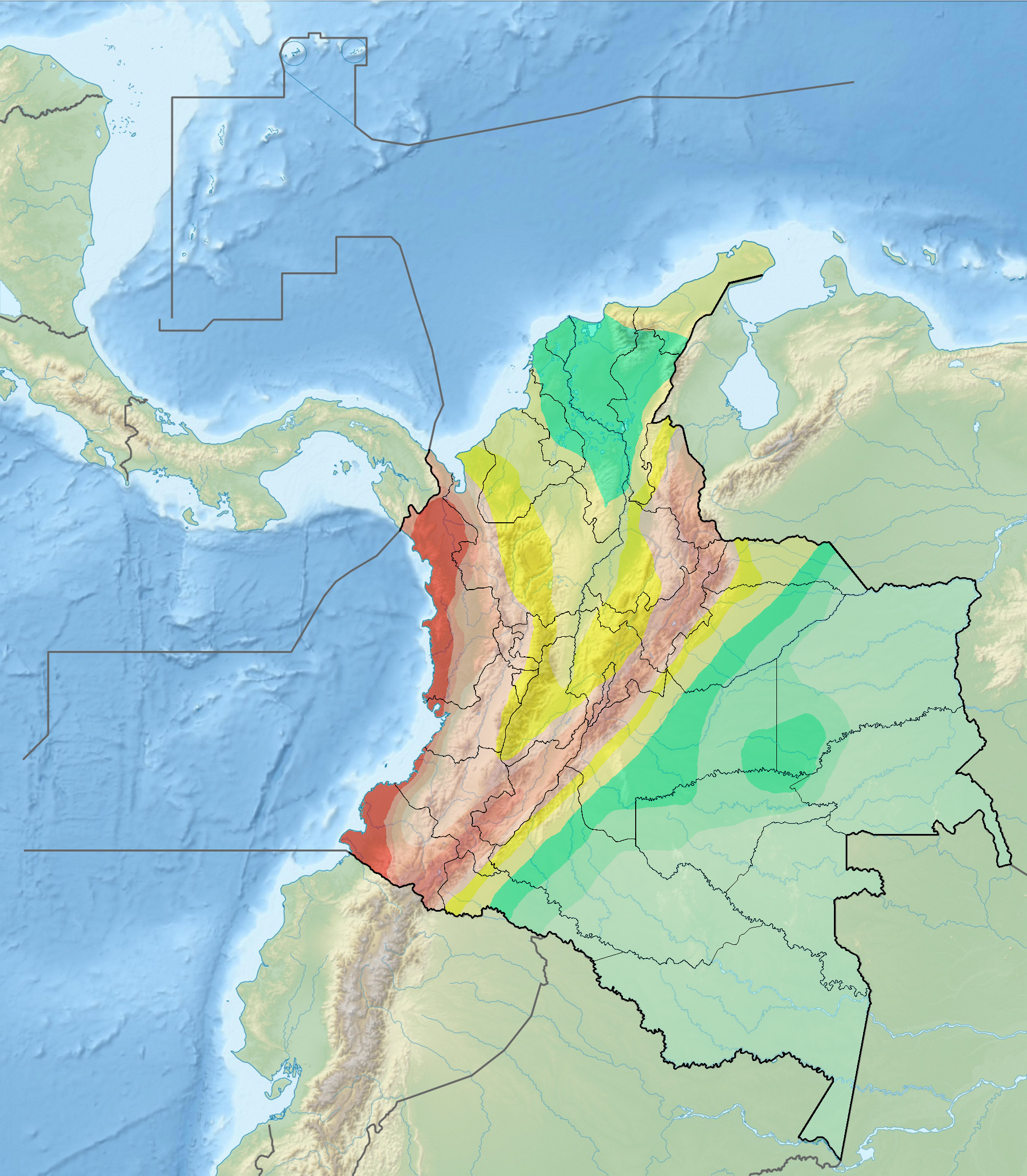
Français : Carte du risque sismique en Colombie |
| Date | |
| Source |
background : File:Colombia relief location map.jpg data : INGEOMINAS |
| Author | Grundkarte Milenioscuro, Relief Alexrk2 |
Licensing
[edit]
This file is licensed under the Creative Commons Attribution-Share Alike 3.0 Unported license.
- You are free:
- to share – to copy, distribute and transmit the work
- to remix – to adapt the work
- Under the following conditions:
- attribution – You must give appropriate credit, provide a link to the license, and indicate if changes were made. You may do so in any reasonable manner, but not in any way that suggests the licensor endorses you or your use.
- share alike – If you remix, transform, or build upon the material, you must distribute your contributions under the same or compatible license as the original.
File history
Click on a date/time to view the file as it appeared at that time.
| Date/Time | Thumbnail | Dimensions | User | Comment | |
|---|---|---|---|---|---|
| current | 14:01, 30 December 2011 | | 2,000 × 2,290 (4.7 MB) | Dr Brains (talk | contribs) |
You cannot overwrite this file.
File usage on Commons
The following 2 pages use this file:
File usage on other wikis
The following other wikis use this file:
- Usage on ast.wikipedia.org
- Usage on en.wikipedia.org
- South American Plate
- Caribbean Plate
- 1994 Páez River earthquake
- 1875 Cúcuta earthquake
- 1999 Colombia earthquake
- Geology of Colombia
- 2008 El Calvario earthquake
- North Andes Plate
- Panama Plate
- 1906 Ecuador–Colombia earthquake
- 1868 Ecuador earthquakes
- List of earthquakes in Colombia
- 1958 Ecuador–Colombia earthquake
- 1979 Tumaco earthquake
- 1970 Colombia earthquake
- 1983 Popayán earthquake
- Oca-Ancón Fault System
- Boconó Fault
- 2016 Ecuador earthquake
- User:Tisquesusa/sandbox8
- Template:Tectonism in Colombia
- Bucaramanga-Santa Marta Fault
- Malpelo Plate
- 1992 Murindó earthquake
- 1967 Neiva earthquake
- Eastern Frontal Fault System
- Romeral Fault System
- Montenegro Fault
- Armenia Fault
- Córdoba-Navarco Fault
- Paraíso Fault
- Piendamó Fault
- Rosas-Julumito Fault
- Buesaco-Aranda Fault
- Abriaquí Fault
- Argelia Fault
- Bagre Norte Fault
- Bahía Solano Fault
- Cañasgordas Fault
- Caño Tomás Fault
- Cimitarra Fault
- Cucuana Fault
- El Tambor Fault
- Espiritú Santo Fault System
- Garrapatas Fault Zone
- Guáitara Fault
- Honda Fault
- Ibagué Fault
- Irlanda Fault
View more global usage of this file.