File:Mars Crustal Magnetism MGS.png
Jump to navigation
Jump to search

Size of this preview: 800 × 549 pixels. Other resolutions: 320 × 219 pixels | 640 × 439 pixels | 1,024 × 702 pixels | 1,280 × 878 pixels | 1,524 × 1,045 pixels.
Original file (1,524 × 1,045 pixels, file size: 1.44 MB, MIME type: image/png)
Captions
Captions
Add a one-line explanation of what this file represents
Summary[edit]
| Description |
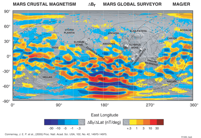
English: The global map is built up from many thousands of orbits at constant altitude (mapping orbit), and uses colors to represent the strength and direction of the field caused by crustal magnetization.
It's originally in TIFF format. I transformed it into PNG format by Photoshop 7.0.1 to make it visible on the net. |
| Date | |
| Source | http://www.nasa.gov/centers/goddard/news/topstory/2005/mgs_plates.html |
| Author | NASA |
Licensing[edit]
| This file is in the public domain in the United States because it was solely created by NASA. NASA copyright policy states that "NASA material is not protected by copyright unless noted". (See Template:PD-USGov, NASA copyright policy page or JPL Image Use Policy.) | ||
 |
Warnings:
|
File history
Click on a date/time to view the file as it appeared at that time.
| Date/Time | Thumbnail | Dimensions | User | Comment | |
|---|---|---|---|---|---|
| current | 05:20, 28 May 2009 | | 1,524 × 1,045 (1.44 MB) | Areong (talk | contribs) | {{Information |Description={{en|1=The global map is built up from many thousands of orbits at constant altitude (mapping orbit), and uses colors to represent the strength and direction of the field caused by crustal magnetization. It's originally in TIF |
You cannot overwrite this file.
File usage on Commons
The following page uses this file:
File usage on other wikis
The following other wikis use this file:
- Usage on be.wikipedia.org
- Usage on en.wikipedia.org
- Usage on fr.wikipedia.org
- Usage on fr.wikibooks.org
- Usage on hy.wikipedia.org
- Usage on nl.wikipedia.org
- Usage on pt.wikipedia.org
- Usage on ru.wikipedia.org
- Usage on uk.wikipedia.org
- Usage on zh.wikipedia.org