File:Matijas Korvin BiH(1463).png
Jump to navigation
Jump to search

Size of this preview: 619 × 599 pixels. Other resolutions: 248 × 240 pixels | 496 × 480 pixels | 793 × 768 pixels | 1,057 × 1,024 pixels | 1,809 × 1,752 pixels.
Original file (1,809 × 1,752 pixels, file size: 115 KB, MIME type: image/png)
Captions
Captions
Add a one-line explanation of what this file represents
Summary[edit]
.png&action=edit§ion=1)
| Description |
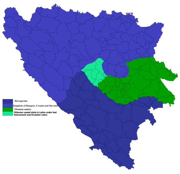
English: territory of todays BiH in 1463
Hrvatski: Teritorij današnje BiH 1463 |
| Source | Vlastito djelo postavljača, podaci preuzeti iz "Povijesni Atlas IRO "Kartografija Učila", Zagreb 1984., Hrvatski povijesni zemljovidi, Josip Lučić, Školska knjiga Zagreb |
| Author | Ceha |
Licensing[edit]
.png&action=edit§ion=2)
| I, the copyright holder of this work, release this work into the public domain. This applies worldwide. In some countries this may not be legally possible; if so: I grant anyone the right to use this work for any purpose, without any conditions, unless such conditions are required by law. |
File history
Click on a date/time to view the file as it appeared at that time.
| Date/Time | Thumbnail | Dimensions | User | Comment | |
|---|---|---|---|---|---|
| current | 08:27, 12 January 2022 | | 1,809 × 1,752 (115 KB) | Ceha (talk | contribs) | Linije |
| 08:24, 12 January 2022 |  | 1,809 × 1,752 (114 KB) | Ceha (talk | contribs) | Matijaš Korvin returned Bobovac and its surrodings https://upload.wikimedia.org/wikipedia/commons/3/38/Osmanska_osvajanja_RH_i_okolice.png https://upload.wikimedia.org/wikipedia/commons/8/8f/Fall_of_Croat_state_in_Bosnia.png | |
| 13:07, 12 December 2019 |  | 1,809 × 1,752 (114 KB) | Ceha (talk | contribs) | There existed small vassal state in Lašva under the last Kotromanić and after him Hrvatinić rulers.... | |
| 08:16, 7 August 2013 |  | 1,809 × 1,752 (110 KB) | Ceha (talk | contribs) | Fixed border around Travnik | |
| 08:01, 7 August 2013 |  | 1,809 × 1,752 (110 KB) | Ceha (talk | contribs) | Promijenio granicu kod Donjeg Vakufa i Žepča | |
| 11:36, 6 December 2010 |  | 1,809 × 1,752 (130 KB) | 123iti (talk | contribs) | More accurate map legend using this source: http://pctrs.network.hu/clubpicture/9/9/_/xv_szazadi_magyarorszag_terkep_99663_370575.jpg | |
| 00:53, 8 July 2009 |  | 1,809 × 1,752 (150 KB) | Ceha (talk | contribs) | {{Information |Description={{en|1=territory of todays BiH in 1463}} {{hr|1=Teritorij današnje BiH 1463}} |Source=Vlastito djelo postavljača |Author=Ceha |Date= |Permission= |other_versions= }} <!--{{ImageUpload|full}}--> |
You cannot overwrite this file.
File usage on Commons
The following 2 pages use this file:
File usage on other wikis
The following other wikis use this file:
- Usage on lt.wikipedia.org
- Usage on ru.wikipedia.org
.png&oldid=646860866)