File:Mauritius (+claim islands).svg
Jump to navigation
Jump to search

Size of this PNG preview of this SVG file: 500 × 463 pixels. Other resolutions: 259 × 240 pixels | 518 × 480 pixels | 829 × 768 pixels | 1,106 × 1,024 pixels | 2,212 × 2,048 pixels.
Original file (SVG file, nominally 500 × 463 pixels, file size: 1.41 MB)
Captions
Captions
Add a one-line explanation of what this file represents
Summary[edit]
.svg&action=edit§ion=1)
| Description |
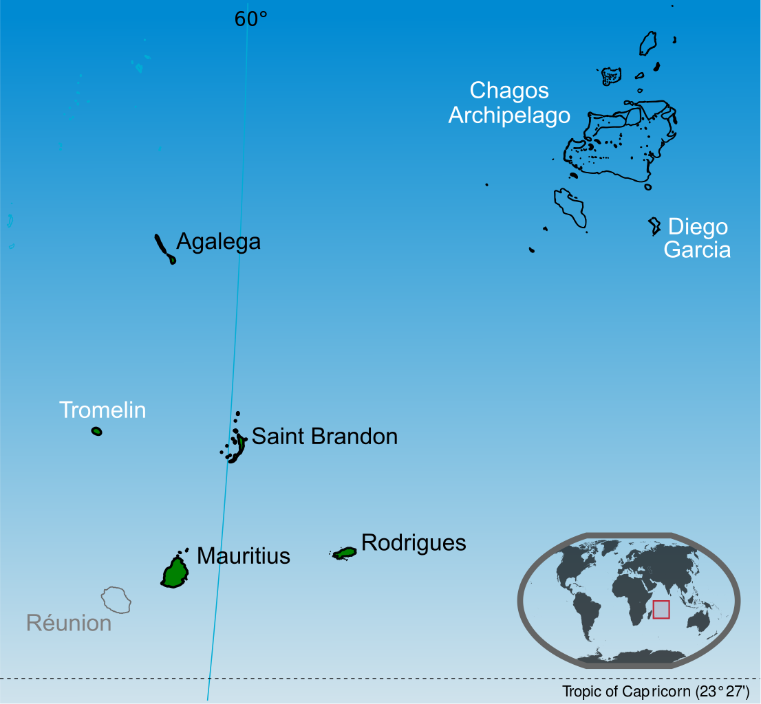
English: Islands of the Republic of Mauritius labelled in black. Mauritius claim Tromelin island claim from France and the Chagos Archipelago from the United Kingdom. |
| Date | |
| Source |
Own work This vector image includes elements that have been taken or adapted from this file: This vector image includes elements that have been taken or adapted from this file: This vector image includes elements that have been taken or adapted from this file: This vector image includes elements that have been taken or adapted from this file: This vector image includes elements that have been taken or adapted from this file: This vector image includes elements that have been taken or adapted from this file: |
| Author | Yashveer Poonit |
| Other versions | Macedonian version |
_mk.svg)
Licensing[edit]
.svg&action=edit§ion=2)
I, the copyright holder of this work, hereby publish it under the following license:
This file is licensed under the Creative Commons Attribution-Share Alike 3.0 Unported license.
- You are free:
- to share – to copy, distribute and transmit the work
- to remix – to adapt the work
- Under the following conditions:
- attribution – You must give appropriate credit, provide a link to the license, and indicate if changes were made. You may do so in any reasonable manner, but not in any way that suggests the licensor endorses you or your use.
- share alike – If you remix, transform, or build upon the material, you must distribute your contributions under the same or compatible license as the original.
File history
Click on a date/time to view the file as it appeared at that time.
| Date/Time | Thumbnail | Dimensions | User | Comment | |
|---|---|---|---|---|---|
| current | 01:24, 14 July 2014 | | 500 × 463 (1.41 MB) | Yash400 (talk | contribs) | use accurate map of Chagos |
| 12:59, 20 January 2014 |  | 500 × 463 (1.37 MB) | Palosirkka (talk | contribs) | larger nominal size | |
| 18:50, 19 January 2014 |  | 255 × 236 (1.37 MB) | Yash400 (talk | contribs) | remove black lines | |
| 18:25, 19 January 2014 |  | 257 × 238 (1.37 MB) | Yash400 (talk | contribs) | change color | |
| 18:08, 20 November 2013 |  | 572 × 530 (1.41 MB) | Yash400 (talk | contribs) | User created page with UploadWizard |
You cannot overwrite this file.
File usage on Commons
The following 4 pages use this file:
File usage on other wikis
The following other wikis use this file:
- Usage on af.wikipedia.org
- Usage on ar.wikipedia.org
- Usage on avk.wikipedia.org
- Usage on bh.wikipedia.org
- Usage on bn.wikipedia.org
- Usage on br.wikipedia.org
- Usage on ca.wikipedia.org
- Usage on ceb.wikipedia.org
- Usage on ckb.wikipedia.org
- Usage on de.wikipedia.org
- Usage on diq.wikipedia.org
- Usage on dty.wikipedia.org
- Usage on en.wikipedia.org
- Usage on es.wikipedia.org
- Usage on eu.wikipedia.org
- Usage on fa.wikipedia.org
- Usage on fi.wikipedia.org
- Usage on frp.wikipedia.org
- Usage on fr.wikipedia.org
- Usage on gl.wikipedia.org
- Usage on gu.wikipedia.org
- Usage on id.wikipedia.org
- Usage on ilo.wikipedia.org
- Usage on incubator.wikimedia.org
- Usage on io.wikipedia.org
- Usage on ja.wikipedia.org
- Usage on ka.wikipedia.org
View more global usage of this file.
.svg)
.svg&oldid=601286016)