File:Midway Atoll map.svg
Jump to navigation
Jump to search

Size of this PNG preview of this SVG file: 365 × 392 pixels. Other resolutions: 223 × 240 pixels | 447 × 480 pixels | 715 × 768 pixels | 953 × 1,024 pixels | 1,907 × 2,048 pixels.
Original file (SVG file, nominally 365 × 392 pixels, file size: 37 KB)
Captions
Captions
Add a one-line explanation of what this file represents
| Description |
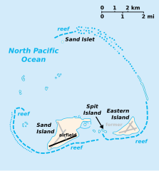
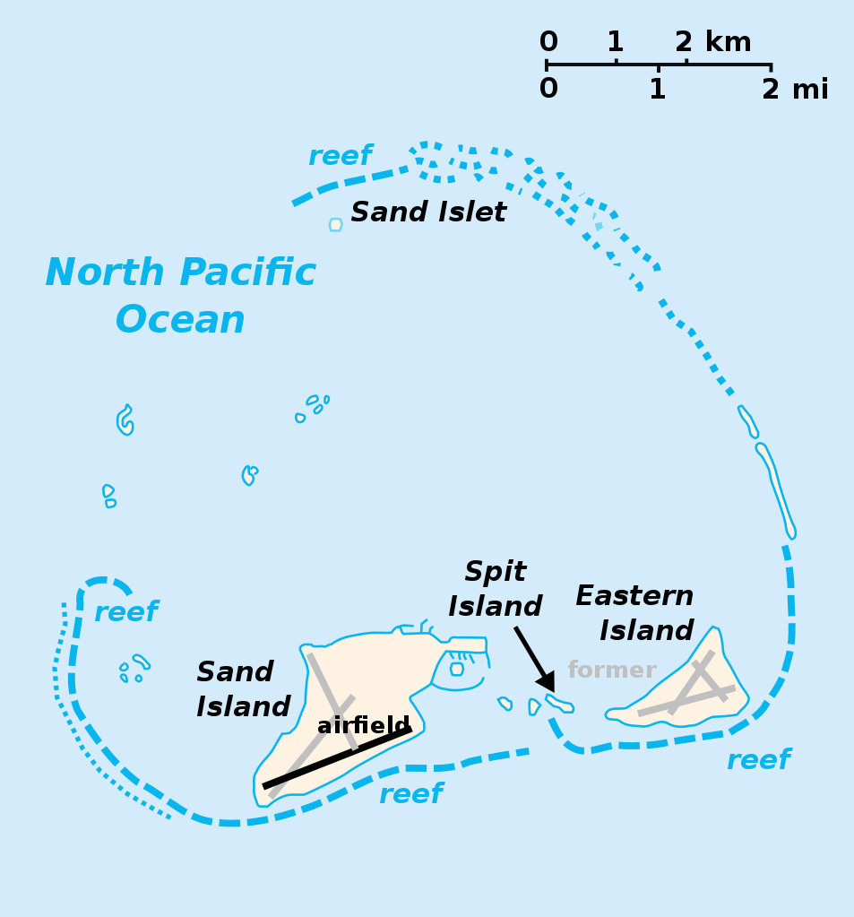
English: Midway Atoll with Sand Island, Spit Island and Eastern Island. Abandoned runways of Henderson Field in gray. |
| Date | |
| Source | |
| Author |
|
| Other versions | File:Midway Atoll map ja.png, Macedonian version |
| This is a retouched picture, which means that it has been digitally altered from its original version. Modifications: color abandoned runways. The original can be viewed here: Midway Islands-CIA WFB Map.png:
|
This file is licensed under the Creative Commons Attribution-Share Alike 3.0 Unported license.
- You are free:
- to share – to copy, distribute and transmit the work
- to remix – to adapt the work
- Under the following conditions:
- attribution – You must give appropriate credit, provide a link to the license, and indicate if changes were made. You may do so in any reasonable manner, but not in any way that suggests the licensor endorses you or your use.
- share alike – If you remix, transform, or build upon the material, you must distribute your contributions under the same or compatible license as the original.
Original upload log[edit]
This image is a derivative work of the following images:
- File:Midway_Islands.svg licensed with PD-self
- 2007-03-26T00:20:33Z Indolences 365x392 (37683 Bytes) cleaning up code
- 2007-02-12T00:24:07Z Indolences 365x392 (44729 Bytes)
- 2007-02-12T00:22:48Z Indolences 365x392 (45062 Bytes) {{Information |Description= the Midway Islands |Source= self made from CIA maps (PD) |Date= 11/2/07 |Author= [[User:Indolences]] |Permission={{PD-self}} |other_versions= }} [[Category:Midway Island]]
- File:Midway_Islands-CIA_WFB_Map.png licensed with PD-USGov-CIA-WF
- 2006-08-13T13:17:15Z Augiasstallputzer~commonswiki 365x392 (17785 Bytes)
- 2005-03-27T09:16:29Z Wolfman 365x392 (8752 Bytes) {{CIA-map}}
Uploaded with derivativeFX
File history
Click on a date/time to view the file as it appeared at that time.
| Date/Time | Thumbnail | Dimensions | User | Comment | |
|---|---|---|---|---|---|
| current | 03:33, 16 November 2009 | | 365 × 392 (37 KB) | Gooney birds (talk | contribs) | {{Information |Description={{en|Midway Atoll with Sand Island, Spit Island and Eastern Island. Abandoned runways of Henderson Field in gray.}} |Source= *File:Midway_Islands-CIA_WFB_Map.png |
You cannot overwrite this file.
File usage on Commons
The following 24 pages use this file:
- Atlas of Midway Atoll
- Atoll
- File:Midway Atoll map-zh.svg
- File:Midway Atoll map de.svg
- File:United States (+overseas), administrative divisions - Nmbrs (marker).svg
- File:United States (+overseas), administrative divisions - Nmbrs (zoom).svg
- File:United States (+overseas), administrative divisions - Nmbrs - colored (marker).svg
- File:United States (+overseas), administrative divisions - Nmbrs - colored (zoom).svg
- File:United States (+overseas), administrative divisions - XY (marker).svg
- File:United States (+overseas), administrative divisions - XY (zoom).svg
- File:United States (+overseas), administrative divisions - XY - colored (marker).svg
- File:United States (+overseas), administrative divisions - XY - colored (zoom).svg
- File:United States (+overseas), administrative divisions - de (marker).svg
- File:United States (+overseas), administrative divisions - de (zoom).svg
- File:United States (+overseas), administrative divisions - de - colored, Noto font (zoom).svg
- File:United States (+overseas), administrative divisions - de - colored (marker).svg
- File:United States (+overseas), administrative divisions - de - colored (zoom).svg
- File:United States (+overseas), administrative divisions - en - colored (zoom).svg
- File:United States (+overseas), administrative divisions - es - colored (zoom).svg
- File:United States (+overseas), administrative divisions - fr - colored (zoom).svg
- File:United States (+overseas), administrative divisions - ja - colored (zoom).svg
- File:United States (+overseas), administrative divisions - zh-hans - colored (zoom).svg
- File:United States (+overseas), administrative divisions - zh-hant - colored (zoom).svg
- Category:Henderson Field (Midway Atoll)
,_administrative_divisions_-_Nmbrs_(marker).svg)
,_administrative_divisions_-_Nmbrs_(zoom).svg)
,_administrative_divisions_-_Nmbrs_-_colored_(marker).svg)
,_administrative_divisions_-_Nmbrs_-_colored_(zoom).svg)
,_administrative_divisions_-_XY_(marker).svg)
,_administrative_divisions_-_XY_(zoom).svg)
,_administrative_divisions_-_XY_-_colored_(marker).svg)
,_administrative_divisions_-_XY_-_colored_(zoom).svg)
,_administrative_divisions_-_de_(marker).svg)
,_administrative_divisions_-_de_(zoom).svg)
,_administrative_divisions_-_de_-_colored,_Noto_font_(zoom).svg)
,_administrative_divisions_-_de_-_colored_(marker).svg)
,_administrative_divisions_-_de_-_colored_(zoom).svg)
,_administrative_divisions_-_en_-_colored_(zoom).svg)
,_administrative_divisions_-_es_-_colored_(zoom).svg)
,_administrative_divisions_-_fr_-_colored_(zoom).svg)
,_administrative_divisions_-_ja_-_colored_(zoom).svg)
,_administrative_divisions_-_zh-hans_-_colored_(zoom).svg)
,_administrative_divisions_-_zh-hant_-_colored_(zoom).svg)
File usage on other wikis
The following other wikis use this file:
- Usage on af.wikipedia.org
- Usage on als.wikipedia.org
- Usage on arz.wikipedia.org
- Usage on ast.wikipedia.org
- Usage on az.wikipedia.org
- Usage on bg.wikipedia.org
- Usage on br.wikipedia.org
- Usage on bs.wikipedia.org
- Usage on ceb.wikipedia.org
- Usage on ce.wikipedia.org
- Usage on cs.wikipedia.org
- Usage on da.wikipedia.org
- Usage on de.wikipedia.org
- Usage on en.wikipedia.org
- Usage on eo.wikipedia.org
- Usage on es.wikipedia.org
- Usage on eu.wikipedia.org
- Usage on fa.wikipedia.org
- Usage on fi.wikipedia.org
- Usage on fo.wikipedia.org
- Usage on frp.wikipedia.org
- Usage on fr.wikipedia.org
- Usage on fr.wiktionary.org
- Usage on gcr.wikipedia.org
- Usage on gl.wikipedia.org
- Usage on hr.wikipedia.org
- Usage on hu.wikipedia.org
- Usage on io.wikipedia.org
- Usage on it.wikipedia.org
- Usage on ja.wikipedia.org
- Usage on ka.wikipedia.org
- Usage on ko.wikipedia.org
- Usage on lij.wikipedia.org
- Usage on li.wikipedia.org
- Usage on lt.wikipedia.org
- Usage on nl.wikipedia.org
- Usage on pl.wikipedia.org
- Usage on pt.wikipedia.org
- Usage on ro.wikipedia.org
- Usage on ru.wikipedia.org
- Usage on sh.wikipedia.org
View more global usage of this file.